X

NV5 Geospatial Blog

Each month, NV5 Geospatial posts new blog content across a variety of categories. Browse our latest posts below to learn about important geospatial information or use the search bar to find a specific topic or author. Stay informed of the latest blog posts, events, and technologies by joining our email list!


New ENVI Agent, IDL Agent, and GeoAgent Quick Guides

New ENVI Agent, IDL Agent, and GeoAgent Quick Guides

6/9/2026

The recent release of ENVI® Agent, IDL® Agent, and GeoAgent™ revolutionize how users interact with geospatial software. These agentic AI applications act as partners to plan, simplify, and execute complex workflows. Knowing where to start can be challenging for new users. To this end, we developed three new quick guides to... Read More >

Introducing NISAR Data Support

Introducing NISAR Data Support

6/5/2026

The release of ENVI® SARscape 6.3 in April 2026 includes preliminary support for NASA-ISRO SAR (NISAR) data. The NISAR mission is a joint Earth-observing satellite project between NASA and the Indian Space Research Organization designed to monitor changes in the planet’s land and ice surfaces using advanced radar imaging. It... Read More >

Monitoring Illegal Mining in the Amazon: Turning Persistent Data Into Actionable Insight

Monitoring Illegal Mining in the Amazon: Turning Persistent Data Into Actionable Insight

5/28/2026

Illegal mining over decades has constituted one of the most persistent and complex socio-environmental problems in the Brazilian Amazon. In recent years, with the increasingly intensive use of mechanized extraction, the associated environmental impacts—such as deforestation, intense soil disturbance, river siltation, and mercury... Read More >

From Answers to Action: Why ENVI and IDL Agents Go Beyond General AI

From Answers to Action: Why ENVI and IDL Agents Go Beyond General AI

4/20/2026

As generative AI tools like Claude and Gemini continue to gain traction, many organizations are asking the same question: Can general purpose AI actually support real geospatial workflows, or does it stop at surface-level answers? That question was front and center in our recent webinar, Meet Your New Partners in Science: ENVI... Read More >

Mapping Earthquake Deformation in Taiwan With ENVI

Mapping Earthquake Deformation in Taiwan With ENVI

12/15/2025

Unlocking Critical Insights With ENVI® Tools Taiwan sits at the junction of major tectonic plates and regularly experiences powerful earthquakes. Understanding how the ground moves during these events is essential for disaster preparedness, public safety, and building community resilience. But traditional approaches like field... Read More >

1345678910Last
«June 2026»
SunMonTueWedThuFriSat
31123456
78910111213
14151617181920
21222324252627
2829301234
567891011
15949 Rate this article:
5.0

Upgrading the GMTED2010 global elevation data included with ENVI

Anonym

The Global Multi-resolution Terrain Elevation Data 2010 (GMTED2010) dataset is the elevation dataset of choice for global and continental scale applications. GMTED2010 is the result of a joint development effort between the U.S. Geological Survey (USGS) and the National Geospatial-Intelligence Agency (NGA). GMTED2010 is a major improvement in consistency and vertical accuracy over GTOPO30.

Starting with version 5.1, the ENVI software installation includes the GMTED2010 dataset for the mean elevation aggregation method at 30 arc-seconds spatial resolution in numerically lossless JPEG2000 format. ENVI provides the GMTED2010 dataset as a convenience for users who need a digital elevation model in their data visualization or image processing workflows. The GMTED2010 dataset can be easily opened in the ENVI software using the "File > Open World Data > Elevation (GMTED2010)" menu option and certain processing tools such as the RPC Orthorectification and Image Registration workflows will automatically use this dataset as the default DEM.

Within the ENVI software installation the GMTED2010 dataset is distributed as a file named "GMTED2010.jp2" that is 152 MB in size and the default path locations are as follows:

Windows: C:\Program Files\Exelis\ENVIxx\data\GMTED2010.jp2
Linux: /usr/local/exelis/ENVIxx/data/GMTED2010.jp2
Macintosh: /Applications/Exelis/ENVIxx/data/GMTED2010.jp2


In the next few weeks an alternate version of the GMTED2010 dataset with 7.5 arc-seconds pixel size will be provided on the Downloads section of the Exelis VIS website (user account required). This upgraded "GMTED2010.jp2" file is 1.54 GB in size and provides a higher spatial resolution global elevation model which can improve the accuracy of RPC Orthorectification and automatic tie-point generation in Image Registration (if at least one input image has RPC metadata).

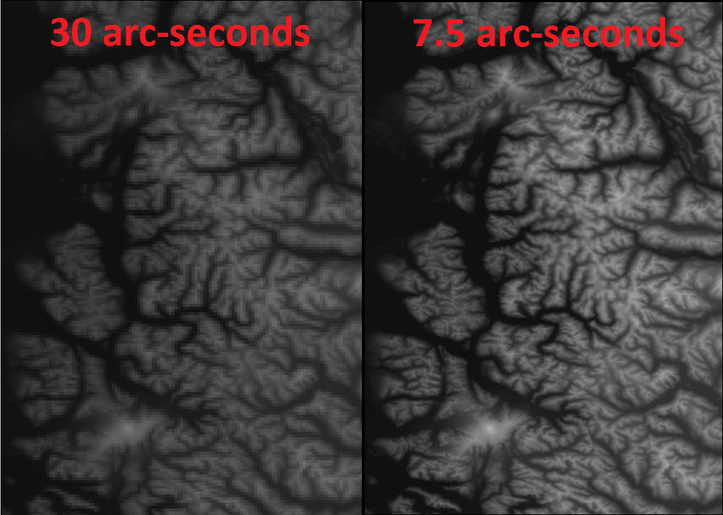
To replace the GMTED2010 dataset in the ENVI software installation with this higher spatial resolution 7.5 arc-seconds version simply overwrite the "GMTED2010.jp2" file in the appropriate path based on computing platform listed above (may require administrative privileges). Here is a screenshot of the 30 arc-seconds dataset distributed as part of the ENVI software installation (left) and the upgraded 7.5 arc-seconds version (right) that you will soon be able to download from our website:

Credit: GMTED2010 dataset provided courtesy of USGS


Reference: Danielson, J.J., and Gesch, D.B., 2011, Global multi-resolution terrain elevation data 2010 (GMTED2010): U.S. Geological Survey Open-File Report 2011–1073, 26 p., https://pubs.usgs.gov/of/2011/1073/pdf/of2011-1073.pdf

Please login or register to post comments.