X

NV5 Geospatial Blog

Each month, NV5 Geospatial posts new blog content across a variety of categories. Browse our latest posts below to learn about important geospatial information or use the search bar to find a specific topic or author. Stay informed of the latest blog posts, events, and technologies by joining our email list!


Monitor, Measure & Mitigate: Integrated Solutions for Geohazard Risk

Monitor, Measure & Mitigate: Integrated Solutions for Geohazard Risk

9/8/2025

Geohazards such as slope instability, erosion, settlement, or seepage pose ongoing risks to critical infrastructure. Roads, railways, pipelines, and utility corridors are especially vulnerable to these natural and human-influenced processes, which can evolve silently until sudden failure occurs. Traditional ground surveys provide only periodic... Read More >

Geo Sessions 2025: Geospatial Vision Beyond the Map

Geo Sessions 2025: Geospatial Vision Beyond the Map

8/5/2025

Lidar, SAR, and Spectral: Geospatial Innovation on the Horizon Last year, Geo Sessions brought together over 5,300 registrants from 159 countries, with attendees representing education, government agencies, consulting, and top geospatial companies like Esri, NOAA, Airbus, Planet, and USGS. At this year's Geo Sessions, NV5 is... Read More >

Not All Supernovae Are Created Equal: Rethinking the Universe’s Measuring Tools

Not All Supernovae Are Created Equal: Rethinking the Universe’s Measuring Tools

6/3/2025

Rethinking the Reliability of Type 1a Supernovae   How do astronomers measure the universe? It all starts with distance. From gauging the size of a galaxy to calculating how fast the universe is expanding, measuring cosmic distances is essential to understanding everything in the sky. For nearby stars, astronomers use... Read More >

Using LLMs To Research Remote Sensing Software: Helpful, but Incomplete

Using LLMs To Research Remote Sensing Software: Helpful, but Incomplete

5/26/2025

Whether you’re new to remote sensing or a seasoned expert, there is no doubt that large language models (LLMs) like OpenAI’s ChatGPT or Google’s Gemini can be incredibly useful in many aspects of research. From exploring the electromagnetic spectrum to creating object detection models using the latest deep learning... Read More >

From Image to Insight: How GEOINT Automation Is Changing the Speed of Decision-Making

From Image to Insight: How GEOINT Automation Is Changing the Speed of Decision-Making

4/28/2025

When every second counts, the ability to process geospatial data rapidly and accurately isn’t just helpful, it’s critical. Geospatial Intelligence (GEOINT) has always played a pivotal role in defense, security, and disaster response. But in high-tempo operations, traditional workflows are no longer fast enough. Analysts are... Read More >

1345678910Last
«September 2025»
SunMonTueWedThuFriSat
31123456
78910111213
14151617181920
21222324252627
2829301234
567891011
16188 Rate this article:
No rating

Using EXIF Metadata to Show Photo Locations in Google Earth, via IDL

Jim Pendleton

Have you ever needed an IDL API for retrieving a geographic location at which a digital camera photo was taken, one stored in a standard format such as a TIFF or JPEG?

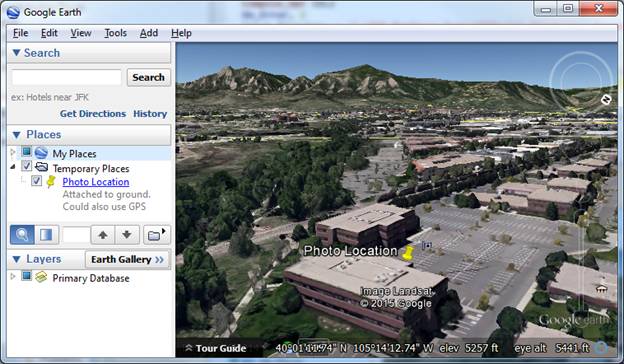
On a lovely spring morning, I shot this photo of a flowering tree in full bloom outside our office building in Boulder, Colorado. When I grow older and daft-er, how will I remember where the photo was taken, plus or minus GPS accuracy?


IDL 8.4.1 includes a new READ_EXIF function for that purpose.


The input is the path to the image file, and the output is a HASH containing much useful metadata.


If GPS tagging was enabled on the device on which the photo was acquired, its contents will be stored in the inelegantly-named but standard key "ifd0_subifd0_GPS".


IDL> r = read_exif(dialog_pickfile())


IDL> if r.haskey('ifd0_subifd0_GPS') then GPSInfo = r['ifd0_subifd0_GPS']

IDL> print, GPSInfo, /implied

{

    "ifd0_subifd0_GPS": {

        "Exif_GPSInfo_GPSLongitude": [105.00000000000000, 14.000000000000000, 10.588900000000001],

        "Exif_GPSInfo_GPSAltitudeRef": 0,

        "Exif_GPSInfo_GPSLatitude": [40.000000000000000, 1.0000000000000000, 13.553400000000000],

        "Exif_GPSInfo_GPSAltitude": 0.00000000000000000,

        "Exif_GPSInfo_GPSTimeStamp": [14.000000000000000, 53.000000000000000, 34.000000000000000],

        "Exif_GPSInfo_GPSProcessingMethod": "ASCII",

        "Exif_GPSInfo_GPSVersionID": [2, 2, 0, 0],

        "Exif_GPSInfo_GPSDateStamp": "2015:04:06",

        "Exif_GPSInfo_GPSLatitudeRef": "N",

        "Exif_GPSInfo_GPSLongitudeRef": "W"

    }

}


The tag names are long and cumbersome, but they use a standard prefix.


IDL> pre = 'Exif_GPSInfo_GPS'


Let's show the location in Google Earth. First extract the longitude and latitude in decimal degrees.


IDL> Lon =Total(Float(GPSInfo[pre+'Longitude'])/[1.,60.,3600.])


IDL> Lon *= GPSInfo[pre+'LongitudeRef'].Compare('W') eq 0 ? -1 : 1

IDL> Lat =Total(Float(GPSInfo[pre+'Latitude'])/[1.,60.,3600.])

IDL> Lat *= GPSInfo[pre+'LatitudeRef'].Compare('N') eq 0 ? 1 : -1


Next, create some KML containing the placemarker location. 


IDL> l = '<?xml version="1.0" encoding="UTF-8"?>'


IDL> l += '<kml xmlns="http://www.opengis.net/kml/2.2">'

IDL> l += '<Placemark>'

IDL> l += '<name>Photo Location</name>'

IDL> l += '<description>Attached to ground.  Could also use GPS altitude.</description>'

IDL> l += '<Point>'

IDL> l += '<coordinates>' + StrJoin([Lon, Lat, 0], ',')  + '</coordinates>'

IDL> l += '</Point>'

IDL> l += '</Placemark>'

IDL> l += '</kml>'


Write the KML to a temporary file.


IDL> tempfile = filepath('test.kml', /tmp)


IDL> openw, lun, tempfile, /get_lun & printf, lun, l & free_lun, lun


If ".kml" is registered as a known extension on your computer, you should be able to simply SPAWN the path to the file.


IDL> spawn, tempfile, /hide, /nowait


Be aware that GPS tagging of photos is generally disabled by default on most mobile devices these days to support a greater level of privacy.  To toggle GPS tagging on, one generally needs to locate a "Settings" or "Options" menu associated with the camera application on a particular device.


Please login or register to post comments.