X

NV5 Geospatial Blog

Each month, NV5 Geospatial posts new blog content across a variety of categories. Browse our latest posts below to learn about important geospatial information or use the search bar to find a specific topic or author. Stay informed of the latest blog posts, events, and technologies by joining our email list!


Using ENVI and IDL Agents with Your Own API Keys

Using ENVI and IDL Agents with Your Own API Keys

6/22/2026

Earlier this year, we introduced the ENVI® Agent and IDL® Agent to bring intelligent, AI-driven automation to your geospatial and data science workflows. If you missed the launch, you can catch up on the full breakdown by watching our release webinar. Both agents are built upon GitHub Copilot, a powerful AI orchestration... Read More >

What We're Looking Forward to at Esri UC 2026

What We're Looking Forward to at Esri UC 2026

6/16/2026

Every year, the Esri User Conference brings together thousands of geospatial professionals to explore new technologies, share ideas, and learn how organizations are solving complex challenges with GIS. For many members of the NV5 team, attending Esri UC is an annual tradition. Some have attended for more than 15 years. Others will be... Read More >

New ENVI Agent, IDL Agent, and GeoAgent Quick Guides

New ENVI Agent, IDL Agent, and GeoAgent Quick Guides

6/9/2026

The recent release of ENVI® Agent, IDL® Agent, and GeoAgent™ revolutionize how users interact with geospatial software. These agentic AI applications act as partners to plan, simplify, and execute complex workflows. Knowing where to start can be challenging for new users. To this end, we developed three new quick guides to... Read More >

Introducing NISAR Data Support

Introducing NISAR Data Support

6/5/2026

The release of ENVI® SARscape 6.3 in April 2026 includes preliminary support for NASA-ISRO SAR (NISAR) data. The NISAR mission is a joint Earth-observing satellite project between NASA and the Indian Space Research Organization designed to monitor changes in the planet’s land and ice surfaces using advanced radar imaging. It... Read More >

Monitoring Illegal Mining in the Amazon: Turning Persistent Data Into Actionable Insight

Monitoring Illegal Mining in the Amazon: Turning Persistent Data Into Actionable Insight

5/28/2026

Illegal mining over decades has constituted one of the most persistent and complex socio-environmental problems in the Brazilian Amazon. In recent years, with the increasingly intensive use of mechanized extraction, the associated environmental impacts—such as deforestation, intense soil disturbance, river siltation, and mercury... Read More >

1345678910Last
30459 Rate this article:
4.6

Using LiDAR to Determine Ideal Solar Panel Placement

Anonym

Cities around the world are searching for new ways to generate power in an effort to lighten the load on traditional power sources. Solar power is a very viable option for many municipalities, and many major cities are investing resources into assessing the impact that large-scale solar projects could have on their energy consumption. As an example, New York City commissioned LiDAR flyovers of the city in 2010 and released a map in 2011 that allows residents to click on their building to find out how much power they could generate by installing panels on that building.

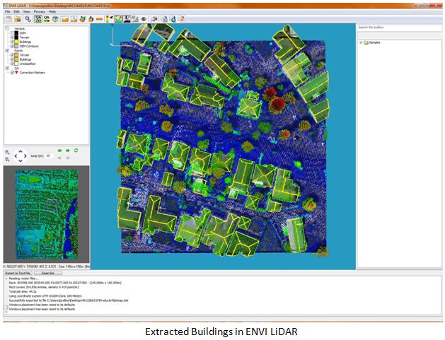
The availability of LiDAR data is increasing for many industries, and it is useful for solar projects as it contains very accurate elevation data that can be used to determine ideal places for solar panel placement, as shown below. The first step was to obtain LiDAR data, which I found on the National Oceanic and Atmospheric Administration's (NOAA) website.  The particular data I found was over the city of Longview, WA. With the data in hand, I used ENVI LiDAR to automatically extract a Digital Surface Model (DSM), building footprints, and rooftop vectors.

LiDAR Digital Surface Model

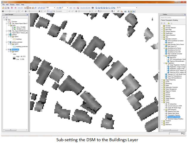
Once I had the building features and surface model extracted, I was able to push them over to ENVI for further analysis.  ENVI allowed me to  subset the DSM to the building layer so I could focus my analysis on the rooftops. Here you can see the sub-setted surface model.


ENVI Surface Model analysis

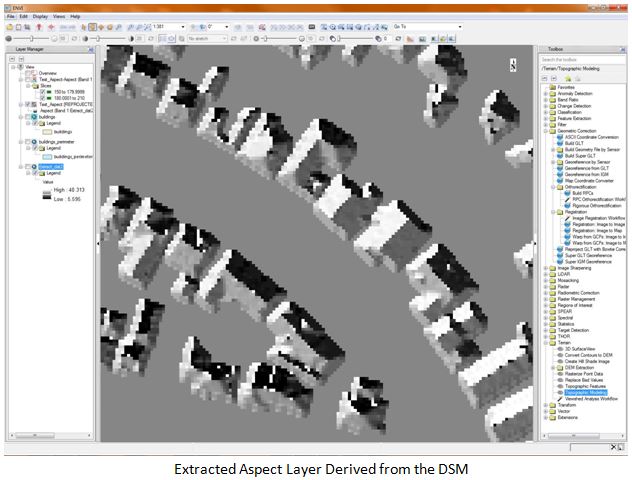
The next step was to run a terrain analysis on the DSM to calculate both the slope and aspect of the building roofs from the scenes. Below you can see the extracted aspect layer. Note how the areas outside of the buildings are flat, as those areas were masked out of the analysis, which allows for quicker analysis and easier interpretation of the results. 

DSM terrain analysis

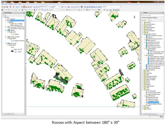
The solar industry tells us that the best aspect for solar panel placement is due South, with a range of plus or minus 30 degrees and a slope with angles between 20 and 40 degrees. Using ENVI, I was able to extract the DSM points that fell within these specifications and create new layers from them. Here you can see the buildings layer with areas of preferred aspect.

Rooftop Feature Extraction

Here you can see the areas with the desired slope attributes for ideal solar panel placement. Ideal Solar Panel Placement

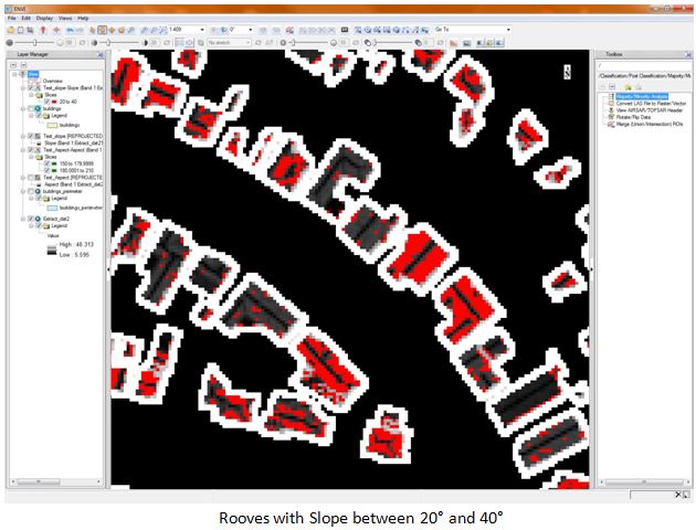
Finally, I was able to combine the two layers to find building rooftops that had both the desired aspect and slope attributes for solar panel placement. I pulled in an imagery basemap layer from Esri to help add context to the analysis.

Esri imagery basemap

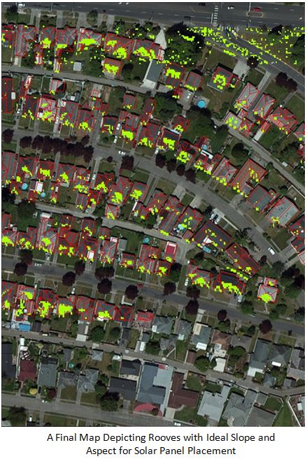
What this analysis proves is that LiDAR provides an extremely accurate method for collecting the data needed to assess solar panel placement suitability. Software such as ENVI LiDAR and ENVI make it easy to automatically extract information from the point cloud, and to run further analysis on it. As more cities look to solar power to alleviate some of their energy needs, the ability to strategically place solar panels will help ensure that design projects will be successful.

What do you think? Does LiDAR data provide the necessary information to assess solar suitability? What other uses for LiDAR are you seeing in your town? 

2 comments on article "Using LiDAR to Determine Ideal Solar Panel Placement"

Avatar image

Keith Jacoby

I really enjoyed reading this--I'm a big fan of grid-tied photo-voltaic arrays. If only 1% of south-facing roofs in the northern hemi had 1 KW of solar panels, the impact on carbon in the atmosphere would be very significant.


Avatar image

Patrick Collins

Thanks for the comment Keith! A lot of work is being done nationwide to reduce the impacts of carbon from energy production. It was a lot of fun seeing how our software could be used by local governments, or even solar companies, to find ideal places to place panels reducing overall spend on project implementation.

Please login or register to post comments.