X

NV5 Geospatial Blog

Each month, NV5 Geospatial posts new blog content across a variety of categories. Browse our latest posts below to learn about important geospatial information or use the search bar to find a specific topic or author. Stay informed of the latest blog posts, events, and technologies by joining our email list!


Not All Supernovae Are Created Equal: Rethinking the Universe’s Measuring Tools

Not All Supernovae Are Created Equal: Rethinking the Universe’s Measuring Tools

6/3/2025

Rethinking the Reliability of Type 1a Supernovae   How do astronomers measure the universe? It all starts with distance. From gauging the size of a galaxy to calculating how fast the universe is expanding, measuring cosmic distances is essential to understanding everything in the sky. For nearby stars, astronomers use... Read More >

Using LLMs To Research Remote Sensing Software: Helpful, but Incomplete

Using LLMs To Research Remote Sensing Software: Helpful, but Incomplete

5/26/2025

Whether you’re new to remote sensing or a seasoned expert, there is no doubt that large language models (LLMs) like OpenAI’s ChatGPT or Google’s Gemini can be incredibly useful in many aspects of research. From exploring the electromagnetic spectrum to creating object detection models using the latest deep learning... Read More >

From Image to Insight: How GEOINT Automation Is Changing the Speed of Decision-Making

From Image to Insight: How GEOINT Automation Is Changing the Speed of Decision-Making

4/28/2025

When every second counts, the ability to process geospatial data rapidly and accurately isn’t just helpful, it’s critical. Geospatial Intelligence (GEOINT) has always played a pivotal role in defense, security, and disaster response. But in high-tempo operations, traditional workflows are no longer fast enough. Analysts are... Read More >

Thermal Infrared Echoes: Illuminating the Last Gasp of a Dying Star

Thermal Infrared Echoes: Illuminating the Last Gasp of a Dying Star

4/24/2025

This blog was written by Eli Dwek, Emeritus, NASA Goddard Space Flight Center, Greenbelt, MD and Research Fellow, Center for Astrophysics, Harvard & Smithsonian, Cambridge, MA. It is the fifth blog in a series showcasing our IDL® Fellows program which supports passionate retired IDL users who may need support to continue their work... Read More >

A New Era of Hyperspectral Imaging with ENVI® and Wyvern’s Open Data Program

A New Era of Hyperspectral Imaging with ENVI® and Wyvern’s Open Data Program

2/25/2025

This blog was written in collaboration with Adam O’Connor from Wyvern.   As hyperspectral imaging (HSI) continues to grow in importance, access to high-quality satellite data is key to unlocking new insights in environmental monitoring, agriculture, forestry, mining, security, energy infrastructure management, and more.... Read More >

1345678910Last
26234 Rate this article:
5.0

Viewshed Analysis with LiDAR!

Anonym

What’s the first thing you think when I say, “image exploitation” or “remote sensing feature extraction?” I bet you are thinking about electro-optical data and time tested analytics to tease out information from imagery that is not initially apparent at first glance. That’s great and still very valuable and useful. But lately I’ve had LiDAR on my mind – perhaps because of the uptick I see day-to-day with its availability and use. In fact, just last week I went to the Earth Explorer site to download a sample image and I saw LiDAR collects as available dataset options.

So I was pleasantly side tracked and downloaded a tile to sample these new data offerings. Not only did I find a very respectable point cloud resolution at approximately 3.5 points per square meter, but I also was surprised to see such comprehensive coverage areas! Now that these data are available, what are some of the ways we can exploit the information into usable intelligence products or GIS layers that will provide solutions to some real-world problems?

We already know that extracting features such as buildings, trees, and power lines helps solve problems ranging from biomass estimation of forest stands, proximity analysis of buildings to unhealthy fire-prone vegetation, power line corridor analysis, and other applications. Additionally, LiDAR enables us to very accurately calculate digital surface models (DSMs) and digital elevation models (DEMs) to ascertain topographic information.

Now that we have highly accurate information at our disposal, what types of analytics ingest this type of information to solve real world problems? The first thing that comes to my mind is a Viewshed analysis.

We can first consider things we know about the area including:

  • Bare Earth DEM
  • DSM (representing features on top of the ground)
  • Distance between points

Next we can specify an observer point where we input:

  • Location of the observer
  • Height of the observer
  • Radius of the view area
  • Visibility parameters (from any point or common visibility shared between two or more points)

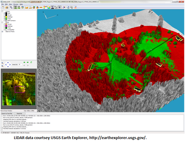
The image below displays one observer point at the fork in the trail of an observer that is 2m tall. Green indicates what the observer can see whereas red indicates obscured areas from that point out to a specified radius (100m).

Viewshed_Analysis_1

A second observer is added along the trail to the East. Note that if the two observers are placed as indicated, there is a corridor through the woods that neither can observer can see.

Viewshed_Analysis_2

This Viewshed analysis has points selected at regular intervals along the major highway in an effort to determine if can of the clear cut areas are visible from the road. According to the results, the clear cut areas cannot be seen from the road.

Viewshed_Analysis_3

I am eager to see applications where Viewshed analysis provides a solution. What other analytics are you planning to perform with LiDAR?

Please login or register to post comments.