X

NV5 Geospatial Blog

Each month, NV5 Geospatial posts new blog content across a variety of categories. Browse our latest posts below to learn about important geospatial information or use the search bar to find a specific topic or author. Stay informed of the latest blog posts, events, and technologies by joining our email list!


Monitor, Measure & Mitigate: Integrated Solutions for Geohazard Risk

Monitor, Measure & Mitigate: Integrated Solutions for Geohazard Risk

9/8/2025

Geohazards such as slope instability, erosion, settlement, or seepage pose ongoing risks to critical infrastructure. Roads, railways, pipelines, and utility corridors are especially vulnerable to these natural and human-influenced processes, which can evolve silently until sudden failure occurs. Traditional ground surveys provide only periodic... Read More >

Geo Sessions 2025: Geospatial Vision Beyond the Map

Geo Sessions 2025: Geospatial Vision Beyond the Map

8/5/2025

Lidar, SAR, and Spectral: Geospatial Innovation on the Horizon Last year, Geo Sessions brought together over 5,300 registrants from 159 countries, with attendees representing education, government agencies, consulting, and top geospatial companies like Esri, NOAA, Airbus, Planet, and USGS. At this year's Geo Sessions, NV5 is... Read More >

Not All Supernovae Are Created Equal: Rethinking the Universe’s Measuring Tools

Not All Supernovae Are Created Equal: Rethinking the Universe’s Measuring Tools

6/3/2025

Rethinking the Reliability of Type 1a Supernovae   How do astronomers measure the universe? It all starts with distance. From gauging the size of a galaxy to calculating how fast the universe is expanding, measuring cosmic distances is essential to understanding everything in the sky. For nearby stars, astronomers use... Read More >

Using LLMs To Research Remote Sensing Software: Helpful, but Incomplete

Using LLMs To Research Remote Sensing Software: Helpful, but Incomplete

5/26/2025

Whether you’re new to remote sensing or a seasoned expert, there is no doubt that large language models (LLMs) like OpenAI’s ChatGPT or Google’s Gemini can be incredibly useful in many aspects of research. From exploring the electromagnetic spectrum to creating object detection models using the latest deep learning... Read More >

From Image to Insight: How GEOINT Automation Is Changing the Speed of Decision-Making

From Image to Insight: How GEOINT Automation Is Changing the Speed of Decision-Making

4/28/2025

When every second counts, the ability to process geospatial data rapidly and accurately isn’t just helpful, it’s critical. Geospatial Intelligence (GEOINT) has always played a pivotal role in defense, security, and disaster response. But in high-tempo operations, traditional workflows are no longer fast enough. Analysts are... Read More >

1345678910Last
«September 2025»
SunMonTueWedThuFriSat
31123456
78910111213
14151617181920
21222324252627
2829301234
567891011
7372 Rate this article:
No rating

Why Adopt JPEG 2000?

Anonym
Recently we (Exelis VIS Europe) got together with Astrium GEO-Information to present an overview of the benefits of adopting JPEG 2000 and to give users a feel for the advantages of adopting this standard. JPEG 2000 is an open standard for compressing very large, multiple-band, and high bit-depth images. Developed to meet the need of increasing file sizes and file transfer, these functional improvements serve well the GIS and remote sensing communities who appreciate the enhanced compression capabilities, low storage overhead, and increased unpacking and download speeds providing access to highly detailed images over very large areas. As a result JPEG 2000 has been successfully adopted by organizations including National Geospatial-Intelligence Agency (NGA), North Atlantic Treaty Organization (NATO), and Open Geospatial Consortium (OGC). 
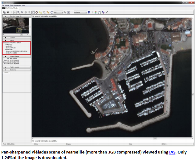
Along with compression, JPEG 2000 achieves flexibility and scalability by managing how the image is compressed (lossy/lossless) and decoded. For example in decoding the user can view the image in various resolutions without creating and storing additional pyramids and can display, pan, and zoom without decompressing the entire image as shown below, speeding process workflows: Adopt_JPEG_Image_1 Another feature of JPEG 2000 of specific interest to client/server deployments is the ISO protocol (JPIP) which provides the ability to stream a region of interest with specific resolution and/or quality without having to decompress and/or download the entire image. This gives users quick access to the data and the ability to review capabilities across large areas of interest in a scene. Since downloading and storing the entire image can be prohibitive, streaming only a portion of the area of interest takes a few seconds and can be achieved over low bandwidths. Adopt_JPEG_Image_2 Increasingly users with the support of tools such as ENVI and IAS are discovering the advantages of adopting the JPEG 2000 protocol. To learn more watch this recorded webinar and download the white paper “Why Adopt JPEG 2000?”
Please login or register to post comments.