Inforest Research Uses ENVI to Deliver Timely Forest Fire Damage Assessments
Anonym
BACKGROUND
In Greece, the forest fire season coincides with tourist season, running from May through October. Trying to manage the influx of tourists into areas that are vulnerable to fire keeps the civil protection authorities and fire service on high alert. Local administrations and municipalities currently do not provide access to mapped assessments for burned areas during or even immediately after a wildfire event. This task falls to central government agencies whose bureaucratic and fiscal processes often delay the dissemination of information. Without timely access to burn assessment maps, civil protection authorities don’t have the information they need to balance safety concerns and the financial concerns of local businesses that rely on the influx of money from tourists during this six months of the year. For the last three years, NV5 (formerly Exelis) partner Inforest Research has been using ENVI software to interpret satellite and airborne imagery to deliver rapid forest fire burn assessment maps that are made freely available. This resource has proved to be of great assistance to local agencies, NGOs and environmental groups.
ENVI SEES THROUGH THE SMOKESCREEN
There are many scenarios where remote sensing analysis can be used to assess and understand a wildfire. These include during-fire disaster response support when recently acquired airborne imagery is most valuable and post-fire forensic analysis, when satellite imagery can aid assessment of the extent of damage. During a fire it is critical to acquire imagery, derive information and pass it on to the personnel fighting the fire as soon as possible. Imagery provided by airborne ISR systems and services are most appropriate in this scenario since imagery of a wildfire begins to lose its usefulness immediately after being acquired.
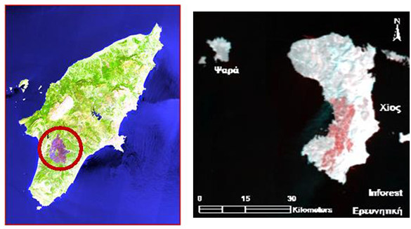 Chios and Rhodes Island analysis using airborne imagery – red areas correspond to fire damaged area.
For analysis, multispectral imagery is of most use as it captures image data at specific frequencies across the electromagnetic spectrum. ENVI image analysis software allows for rapid visualization of multispectral imagery using unique combinations of spectral bands from the visible SWIR and LWIR wavelengths. The thermal properties captured in the LWIR wavelengths can help identify hotspots and distinguish high (colder) clouds from low (warmer) smoke. Furthermore, light in the SWIR wavelength region can penetrate haze and certain types of smoke. In other words, SWIR-based imaging empowers the user to “see through” smoke to better analyze the active zone of a forest fire and identify hotspots. Multiple visualizations of the same scene can be compared side-by-side using the multiple views available in the ENVI interface. Users can also load multiple representations into a single view and turn layers on and off, adjust the transparency of layers, or use the swipe, fade and portal viewer options to determine the best combinations of spectral bands for examining a scene.
One useful analysis technique for post-fire forensics is the calculation of spectral indices such as the Normalized Burn Ratio now available in ENVI 5.2 within the new "Spectral Index" tool and associated programmatic API. When Normalized Burn Ratio is calculated it produces a raster image where darker pixels indicate burned areas. However, the real power of the Normalized Burn Ratio spectral index is exhibited when you create pre-fire and post-fire NBR images then subtract the post-fire NBR raster from the pre-fire NBR raster to create a Differenced Normalized Burn Ratio (DNBR) image that indicates burn severity. This DNBR = PreFireNBR - PostFireNBR raster calculation can easily be executed using the "Band Math" tool within the ENVI software.
Inforest Research uses ENVI software to interpret satellite and airborne imagery of affected areas to provide rapid, free-to-access forest fire burn assessments.
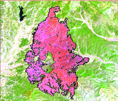 Post-fire forensic scenario – analysis of the area after a forest fire usig satellite imagery.
EXTENDING BENEFITS TO THE WIDER COMMUNITY
Inforest Research relies on free remote sensing data sources (MODIS and more recently Landsat 8 OLI datasets) in combination with the semi-automatic processing in ENVI to produce map products for burned areas and major fires occurrences. From these assessment maps, Inforest Research produces newsletters distributed directly to local authorities making the methodology available so institutions and users to repeat and implement the process. Beneficiaries include not only local government but also conservation NGOs such as WWF Greece.