Deployable Tactical Analytics Kit (DTAK)
A Flexible Solution for Enhanced Real-Time Intelligence
Authors: James Lewis and Kalil Negron (NV5)
Executive Summary
The Deployable Tactical Analytics Kit (DTAK) is a state-of-the-art system combining sophisticated hardware with advanced geospatial data visualization, real-time analytics, and AI-driven insights to support teams in high-stakes field operations. Designed to meet the unique challenges of military, law enforcement, and disaster responders, DTAK addresses pain points such as:
-
Delays caused by lack of real-time data.
-
Operational inefficiencies stemming from non-portable or fragile systems.
-
Challenges posed by environmental constraints and limited connectivity.
By integrating the Android Tactical Assault Kit (ATAK), live video and imagery analytics, advanced AI features, and customizable interfaces, DTAK empowers field teams to make rapid, informed decisions, ensuring operational efficiency and mission success even in the most demanding conditions.
This white paper explores how DTAK’s capabilities address modern tactical needs, offering innovative solutions to longstanding operational challenges.
Introduction
Tactical field operations, whether in military missions, disaster response, or law enforcement, demand rapid, data-driven decision-making in environments that are often unpredictable and unforgiving. Despite advancements in technology, real-time geospatial data visualization and analysis remain significant challenges due to:
-
Environmental constraints such as extreme weather, rugged terrain, and limited infrastructure.
-
Connectivity limitations, particularly in remote or austere regions.
-
Inflexible and fragile systems, which lack the durability and adaptability to operate effectively in high-stakes, dynamic environments.
These limitations can result in delayed decisions, compromised operational efficiency, and increased risk to personnel and mission success. A specialized, resilient, and portable solution is required to bridge these gaps and enable informed, timely strategic decisions.
Solution Overview: Deployable Tactical Analytics Kit (DTAK)
DTAK addresses the critical challenges of tactical operations by delivering a modular, portable, and robust system that integrates cutting-edge geospatial data capabilities with real-time analytics. DTAK provides:
-
Real-time situational awareness through seamless geospatial data visualization and analysis.
-
Advanced analytics powered by AI-driven insights, live imagery, and video analysis.
DTAK integrates the ATAK, geospatial data processing, and multimedia capabilities into a single deployable system. By combining these tools, it ensures enhanced decision-making, operational safety, and mission success in environments where precision and speed are paramount.
Core Features
-
Modular Design: Configurable to suit specific mission needs, such as movement detection, weather monitoring, or communication analysis.
-
Ruggedized or COTS Hardware: Built to withstand harsh environments, including extreme temperatures, moisture, and shock, minimizing maintenance needs.
-
Real-Time Data Processing: Processes geospatial and video data from satellite, airborne, and ground-based sensors without requiring internet connectivity.
-
High-Level Encryption and Data Security: Protects sensitive information with robust encryption and secure data transmission protocols.
-
Field-Friendly Interface: Designed for high-pressure environments, offering intuitive workflows that enable rapid deployment and minimal training.
-
Video Integration: Supports live video feeds from drones, body cameras, and stationary cameras, enabling real-time analysis and detailed after-action reviews.
Advanced Analytics and AI Integration
-
Geospatial Data Analysis: Identifies terrain patterns, potential risks, and optimal routes for mission planning.
-
Video Analytics: Detects anomalies and tracks movements to inform immediate actions.
-
Sensor Data Monitoring: Tracks environmental conditions and resource usage to optimize operations.
-
Predictive Analytics:
-
Threat Detection: Identifies potential risks, such as unusual movement patterns, enabling proactive measures.
-
Resource Allocation: Recommends efficient use of personnel and equipment based on data insights.
Customization and Compatibility
-
Custom Applications and Databases: Tailor DTAK with mission-specific analytical models and tools.
-
ATAK Integration: Fully compatible with ATAK, enhancing geospatial data analysis, real-time mapping, and team coordination.
-
Scalability: Adaptable for a range of operations, from small-unit missions to large-scale deployments, ensuring teams have the precise tools they need for any scope.
Technological Advantages
AI and Machine Learning for Predictive Insights
DTAK leverages artificial intelligence and machine learning algorithms to analyze large volumes of data in real time, enabling predictive insights that help teams anticipate challenges and respond proactively. For example:
-
Threat Detection: AI identifies unusual patterns or anomalies, such as suspicious movement or environmental changes, allowing teams to mitigate risks before they escalate.
-
Resource Allocation: Machine learning models optimize personnel and equipment deployment by analyzing historical data and current operational conditions.
-
Mission Planning: Predictive analytics streamline decision-making, ensuring that strategies are both efficient and adaptable to changing circumstances.
Geospatial Visualization for Detailed Operational Planning
Geospatial data is a cornerstone of tactical decision-making, and DTAK excels in transforming complex data into intuitive, actionable visualizations. These tools enable teams to:
-
Analyze terrain, routes, and obstacles for mission planning.
-
Monitor live geospatial updates, such as troop movements, weather changes, or disaster impacts.
-
Identify safe zones, potential hazards, and optimal paths for personnel and vehicles.
Video and Imagery Analysis for Enhanced Situational Clarity
DTAK processes and analyzes live video and imagery in real time, offering:
-
Anomaly Detection: AI-driven analysis of drone feeds and body cameras to identify potential threats or irregularities.
-
Movement Tracking: Real-time tracking of people, vehicles, or objects to enhance situational awareness.
-
Post-Mission Reviews: Detailed analysis of recorded video for after-action reporting and strategy refinement.
Encryption and Data Security to Protect Sensitive Operations
DTAK employs robust encryption protocols and advanced security measures to ensure sensitive information remains protected. Features include:
-
End-to-End Encryption: Secures data transmission across all channels, preventing interception or unauthorized access.
-
Access Control: Ensures only authorized personnel can retrieve, share, or modify data.
-
Secure Storage: Protects geospatial, video, and analytical data both on devices and in cloud-based environments.
Integration with ENVI® and NV5 Technology
The seamless integration of DTAK with ENVI and NV5 geospatial products creates a robust ecosystem for advanced geospatial data analysis, visualization, and collaboration. This integration ensures that teams are equipped with cutting-edge tools to transform geospatial data into actionable intelligence, regardless of the mission's complexity or environment.
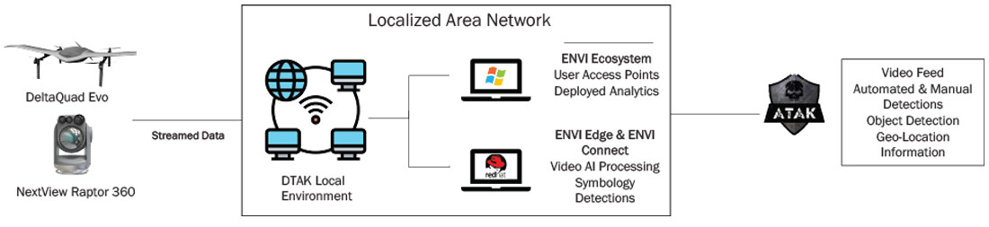
The configuration above showcases an end-to-end implementation of the ecosystem of tools.
ENVI Integration
ENVI, a premier geospatial analytics software, enhances DTAK’s capabilities by providing powerful tools for analyzing and visualizing satellite imagery, airborne data, and other geospatial data. By leveraging ENVI’s robust features, DTAK users can:
-
Perform in-depth terrain analysis to identify risks, plan routes, or assess environmental factors in real-time.
-
Use advanced image analytics to extract actionable insights, such as change detection, object identification, and classification.
-
Conduct spectral analysis to identify materials, vegetation health, or anomalies critical to mission success.
ENVI Edge for Real-Time Analytics
ENVI Edge extends DTAK’s capabilities by enabling real-time data processing at the point of collection. This is particularly beneficial for operations in remote or resource-constrained environments, where speed and autonomy are paramount. ENVI Edge allows teams to:
-
Analyze data from drones, body cameras, or sensors directly in the field without requiring constant connectivity to a centralized system.
-
Gain immediate insights from video feeds and imagery, supporting time-sensitive decisions.
ENVI Connect for Enhanced Collaboration
ENVI Connect facilitates secure, cloud-based sharing and collaboration, ensuring that data and insights derived from DTAK are accessible to all relevant team members and stakeholders. Key benefits include:
-
Seamless data sharing between teams in the field and command centers, enhancing situational awareness and operational coordination.
-
Centralized storage for geospatial data, video feeds, and analytics results, ensuring continuity and accessibility across all mission phases.
Comprehensive ENVI Ecosystem
By integrating with NV5’s suite of geospatial products, DTAK becomes a critical component of a comprehensive tactical analytics ecosystem. This ecosystem provides unmatched flexibility, enabling teams to scale from small operations to large, multi-agency deployments. The combination of DTAK, ENVI, ENVI Edge, and ENVI Connect delivers:
-
Scalable Analytics: From edge computing in remote environments to centralized processing for complex datasets, the NV5 ecosystem adapts to meet mission requirements.
-
Interoperable Systems: Ensures compatibility with other tools and platforms, streamlining workflows and enhancing operational efficiency.
-
Real-Time and Post-Mission Insights: Supports both immediate tactical decisions and detailed after-action reviews with comprehensive data analysis and visualization tools.
Implementation and Deployment
Steps for Integrating DTAK into Field Operations
DTAK’s modular design and scalability support small-scale missions and large, multi-agency operations, ensuring flexibility and adaptability. NV5 will work with you and your team to implement a DTAK deployment that meets your mission needs. The implementation and deployment include:
Assessment and Customization:
-
Conduct a needs analysis to identify mission-specific requirements.
-
Customize the DTAK system to align with operational environments, including integration with existing systems like ATAK and ENVI.
System Installation and Configuration:
-
Deploy ruggedized or COTS hardware, ensuring compatibility with environmental conditions.
-
Establish secure connectivity for data exchange between field teams and command centers.
Operational Testing:
Field Deployment:
Training and Support for Personnel:
-
Basic Training: Introduce personnel to DTAK’s core features.
-
Advanced Training: Provide in-depth instruction on AI-driven analytics and customization.
-
Hands-On Simulations: Conduct realistic simulations to enhance personnel familiarity.
-
Ongoing Support: Technical assistance and continuous updates will ensure alignment with evolving needs.
Example Use Cases
Military Operations
DTAK revolutionizes battlefield situational awareness by integrating live data streams and AI-driven analysis. For instance, during tactical operations, DTAK’s live video feed and AI analysis of drone footage can highlight enemy troop movements in real time. This enables commanders to make immediate strategic adjustments, reallocating resources and optimizing unit positioning. The result can be a significant increase in mission success rates and a reduction in casualties, demonstrating how DTAK empowers military forces to stay ahead in dynamic and high-stakes environments.
Disaster Response
In the aftermath of a hurricane, DTAK can be used to prioritize emergency operations. The system can combine flood map data and real-time drone footage to analyze affected areas, identifying regions with the greatest need. This allows first responders to efficiently allocate resources, such as medical teams and evacuation support, drastically reducing response times. Communities can benefit from faster aid delivery showcasing how DTAK streamlines disaster management for better outcomes.
Border Security
DTAK’s advanced AI capabilities can significantly enhance border security by detecting and responding to potential threats. For example, AI-driven anomaly detection can flag unusual movement patterns along a specific 5-mile border stretch. The system can alert authorities, enabling rapid deployment of personnel to intercept potential threats, thereby preventing illegal crossings and ensuring border integrity. This proactive approach not only saves time but also increases operational efficiency by focusing resources where they were most needed.
Conclusion
NV5’s Deployable Tactical Analytics Kit (DTAK) redefines the standard for situational awareness and operational intelligence in mission-critical environments. Its cutting-edge capabilities, including advanced AI, seamless integration with ATAK, and robust geospatial and video analytics, enable teams to operate with precision, agility, and confidence. Whether optimizing battlefield strategies, enhancing disaster response, or securing borders, DTAK ensures that decision-makers have the tools they need to adapt swiftly to evolving challenges.
Want to learn more? For a customized demo or additional information, simply contact us.