X
836

The Urgency of Conservation in the Caribbean


The Caribbean is one of the world’s most biodiverse marine regions. The coral reefs, mangroves, and seagrass beds support a vast array of marine life such as endangered sea turtles, manatees, and sharks. The urgency of protecting Caribbean marine life and the ecosystem services that nature provides is critical due to escalating threats from climate change, overfishing, habitat destruction, and pollution.

Healthy marine ecosystems are essential for fisheries, tourism, and coastal protection, sustaining millions of people in the region. Strengthening marine protected areas, enforcing sustainable fishing practices, and reducing pollution are crucial steps in safeguarding species and ensuring the long-term resilience of the Caribbean’s marine environment.

“The Nature Conservancy’s (TNC) Caribbean Division works across 17 countries and territories—many of them are small island developing states that have very limited resources for creating their own science-based data and models,” says Dr. Steve Schill, Lead Scientist for TNC’s Caribbean Division. “Our team works to provide accurate data and decision-support tools to assist governments in prioritizing conservation actions in areas that will have the greatest impact on both biodiversity and local communities.”

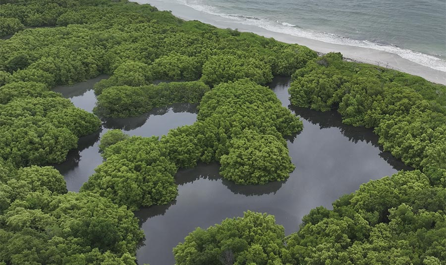
A drone photo acquired over a mangrove swamp in eastern Jamaica. These mangrove provide important coastal protection, fisheries production, and carbon sequestration benefits.

A Data-Driven Approach to Protecting Nature

A deep seafloor habitat classification that was derived from bathymetry and substrate data for the Caribbean Basin. These habitats likely harbor unique biodiversity and are being used to expand marine protection across the deep ocean.

To support these efforts, Schill’s team employs a suite of geospatial tools, integrating satellite imagery, drone-based surveys, AI-powered habitat classification, and bathymetric modeling to create highly detailed conservation maps.


Using ENVI® image analysis software, they conduct:

  • Feature extraction and object-based classification – Differentiating between coral reefs, seagrass meadows, mangrove forests, and other critical habitats.

  • Spectral analysis using vegetation indices – Identifying ecological trends and tracking environmental changes such as coral bleaching and mangrove die-off.

  • Mosaicking and lidar processing – Stitching together high-resolution maps and analyzing topography to enhance ecosystem assessments.

  • Multiband radar analysis – Delineating wetland forests and identifying key mangrove restoration zones.

“ENVI is one of the most powerful tools in our toolkit. It allows us to do spectral separation, feature space visualization, and target detection, which ensures our habitat maps are both accurate and reliable. It also has fantastic lidar tools for analyzing point clouds and creating topographic models, as well as AI-driven classification tools that streamline the entire process.”
 

- Dr. Steve Schill, Lead Scientist for TNC’s Caribbean Division

These data-driven maps inform large-scale conservation strategies, including:

  • Identifying “no-regret” restoration sites – Where mangroves, seagrass, and coral reefs can be rehabilitated to reduce storm surge impacts and protect coastal communities.

  • Expanding Marine Protected Areas (MPAs) – As part of the global 30x30 initiative, aiming to safeguard 30% of the world’s oceans by 2030.

  • Supporting ecotourism and sustainable fisheries – Ensuring that valuable economic species like the Nassau Grouper, Queen Conch, and Caribbean Spiny Lobster can recover from overfishing.

  • Tracking climate change effects – Monitoring coral bleaching events, seagrass loss, and mangrove deforestation, which are critical indicators of ocean health.

A mangrove forest in Los Haitises National Park, Dominican Republic. These mangroves provide critical habitat for birds and fish and help trap sediment that leads to improved water quality.

Beyond the Shoreline: The Role of Bathymetry

A marine scientist surveying elkhorn coral in St Croix, USVI, an important reef-building coral in the Caribbean. These corals grow in the shallow reef areas and are important for wave attenuation, coastal protection, and create habitat and shelter for many other reef species.

In the clear waters of the Caribbean, sunlight can reflect off the ocean bottom up to 30m deep, providing valuable information for mapping shallow coastal ecosystems. The team uses Satellite-Derived Bathymetry (SDB) methods to model underwater topography by analyzing light absorption and reflection patters throughout the water column. TNC scientists validate these depth models using transducer-based field surveys, ensuring accuracy for activities such as marine spatial planning.


Why Is Bathymetry Important for Conservation?

  • Identifying underwater biodiversity hotspots – Finding seamounts, ridges, and deep-sea canyons that support rare marine life.

  • Guiding Marine Protected Area (MPA) expansion – Ensuring that key habitats are included in conservation zones.

  • Predicting coastal resilience – Helping scientists understand where coral reefs and seagrass beds act as natural storm barriers.

Deep Ocean Habitat Classification: How TNC Maps the Unseen

While much of TNC’s work focuses on shallow coastal ecosystems, Schill’s team is also exploring methods for mapping biodiversity across the deep ocean. “For deeper waters, we rely on global bathymetry and substrate datasets, using GIS-models and AI-driven geospatial analysis to predict areas that may harbor unique pockets of biodiversity. These areas include deep ocean seamounts, ridges, canyons, and other unique geomorphic zones.”

Many countries are interested in creating deep ocean Marine Protected Areas within their Exclusive Economic Zone (EEZ), however the lack of data for these areas has limited the design and implementation. TNC’s products are helping to fill the data void and promote MPA expansion in these areas.

“Global mapping products are often limited in their applicability at the island level,” Schill explains. “What we do is collect new high-resolution satellite and drone data, conduct field surveys, and create localized maps that are far more accurate and useful to decision-makers.”

Using deep learning algorithms, coral colonies can be automatically detected from high resolution drone imagery and provide a powerful monitoring tool for coral reef managers.

Key Data Sources Used for Habitat Mapping:

Satellite Imagery (Sentinel-2, PlanetScope, etc.) – Captures regional and national-scale environmental changes.

Drone Imagery – Provides high-resolution local-scale mapping and monitoring of mangroves, seagrass, and coral reefs.

AI-Powered Classification (ENVI and eCognition) – Differentiates land and benthic cover types, detecting subtle habitat condition and variations when integrated with field data.

Multiband Radar and Lidar – Used for wetland and mangrove delineation, forest analysis, and topographic modeling.

Field Surveys and Ground-Truthing – Validates remote sensing data with on-the-ground measurements and ecological assessments.

The Power of Local Partnerships

One of TNC’s core missions is to empower local communities and conservation organizations. Rather than conducting research in isolation, Schill’s team collaborates closely with government agencies, NGOs, and Indigenous groups to ensure that their data is accessible and actionable. The team has conducted GIS and drone training sessions across the Caribbean to help strengthen partner capacity.

Key Collaborative Projects:

  • Barbados Marine Spatial Plan – Developing an EEZ-wide national plan that establishes 30% marine protection while allocating zones for important economic activities in the tourism, fishing, and energy sectors.

  • Bahamas and Jamaica Mangrove Mapping Initiative – Utilizing AI-driven classification to map mangrove forests and identify restoration zones.

  • Union Island Gecko Conservation – Using drone imagery and habitat mapping to protect the endangered Union Island gecko from illegal wildlife trafficking in Saint Vincent & the Grenadines.

“We don’t just hand over maps,” Schill notes. “We train local partners in remote sensing and GIS so they can take ownership of conservation efforts. That way, when a country is making decisions about its marine protected areas or coral reef restoration sites, they have the tools and knowledge to act.”

The Future of Conservation Mapping


As the climate crisis accelerates, the need for high-quality geospatial data has never been greater. For Schill and his team, tools like ENVI and advanced remote sensing technology are essential for staying ahead of environmental threats and protecting the Caribbean’s natural heritage.

By leveraging the power of technology, partnerships, and local knowledge, TNC and NV5 are proving that conservation is not just about protecting nature, it’s about ensuring a sustainable future for people and nature alike.

“With ENVI, we can analyze complex landscapes, detect environmental changes, and provide data-driven solutions that help safeguard ecosystems for future generations,” Schill says.”

Looking to better understand and protect our changing world?

ENVI offers powerful tools to help you understand complex ecosystems and make informed decisions. Contact us today to see how our software and solutions can support your mission.

A marine scientist conducts a photo transect survey in a seagrass bed in southern Jamaica. These data are used to estimate the health and carbon storage capacity of seagrass beds.


Images courtesy of Steve Schill, TNC