X

NV5 Geospatial Blog

Each month, NV5 Geospatial posts new blog content across a variety of categories. Browse our latest posts below to learn about important geospatial information or use the search bar to find a specific topic or author. Stay informed of the latest blog posts, events, and technologies by joining our email list!


Not All Supernovae Are Created Equal: Rethinking the Universe’s Measuring Tools

Not All Supernovae Are Created Equal: Rethinking the Universe’s Measuring Tools

6/3/2025

Rethinking the Reliability of Type 1a Supernovae   How do astronomers measure the universe? It all starts with distance. From gauging the size of a galaxy to calculating how fast the universe is expanding, measuring cosmic distances is essential to understanding everything in the sky. For nearby stars, astronomers use... Read More >

Using LLMs To Research Remote Sensing Software: Helpful, but Incomplete

Using LLMs To Research Remote Sensing Software: Helpful, but Incomplete

5/26/2025

Whether you’re new to remote sensing or a seasoned expert, there is no doubt that large language models (LLMs) like OpenAI’s ChatGPT or Google’s Gemini can be incredibly useful in many aspects of research. From exploring the electromagnetic spectrum to creating object detection models using the latest deep learning... Read More >

From Image to Insight: How GEOINT Automation Is Changing the Speed of Decision-Making

From Image to Insight: How GEOINT Automation Is Changing the Speed of Decision-Making

4/28/2025

When every second counts, the ability to process geospatial data rapidly and accurately isn’t just helpful, it’s critical. Geospatial Intelligence (GEOINT) has always played a pivotal role in defense, security, and disaster response. But in high-tempo operations, traditional workflows are no longer fast enough. Analysts are... Read More >

Thermal Infrared Echoes: Illuminating the Last Gasp of a Dying Star

Thermal Infrared Echoes: Illuminating the Last Gasp of a Dying Star

4/24/2025

This blog was written by Eli Dwek, Emeritus, NASA Goddard Space Flight Center, Greenbelt, MD and Research Fellow, Center for Astrophysics, Harvard & Smithsonian, Cambridge, MA. It is the fifth blog in a series showcasing our IDL® Fellows program which supports passionate retired IDL users who may need support to continue their work... Read More >

A New Era of Hyperspectral Imaging with ENVI® and Wyvern’s Open Data Program

A New Era of Hyperspectral Imaging with ENVI® and Wyvern’s Open Data Program

2/25/2025

This blog was written in collaboration with Adam O’Connor from Wyvern.   As hyperspectral imaging (HSI) continues to grow in importance, access to high-quality satellite data is key to unlocking new insights in environmental monitoring, agriculture, forestry, mining, security, energy infrastructure management, and more.... Read More >

1345678910Last
15036 Rate this article:
4.3

Basics of Map Coordinate Systems

A brief discussion about a few of the basic terms and elements of geodesy, cartography and coordinate systems

Anonym

Geodesy: The scientific discipline that deals with the measurement and representation of the Earth.

Cartography: The study and practice of making maps.

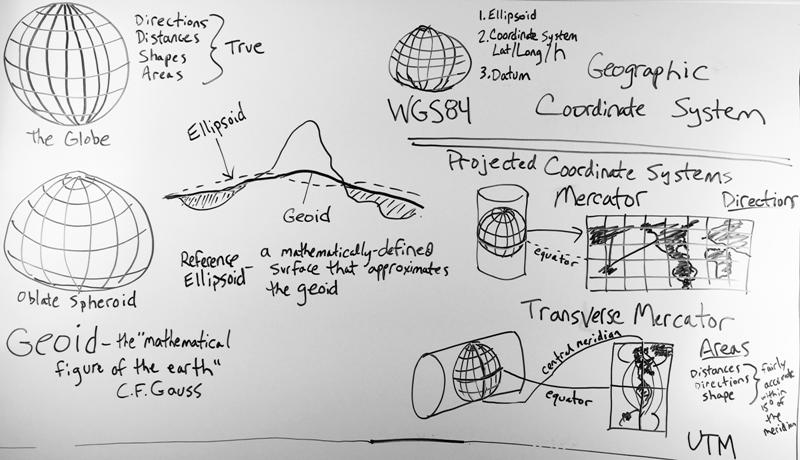
Geoid: C.F. Gauss, who first described it, called it the “mathematical figure of the Earth”. It is a smooth but highly irregular surface that can be derived only through extensive gravitational measurements and calculations. This gravity-defined equipotential surface theoretically would coincide with the mean ocean surface of the Earth, if the oceans and atmosphere were in equilibrium, at rest relative to the rotating Earth, and the seas extended through the continents (such as with a series of very narrow canals). The geoid is a much closer approximation of the true shape of the Earth than any reference ellipsoid could provide.

Reference Ellipsoid: A mathematically-defined surface that approximates the geoid. Because it is an idealized model of relative simplicity,reference ellipsoids are used as a preferred surface on which geodetic network computations are performed and point coordinates such as latitude, longitude and elevation are defined.

Datum: A datum is needed to be able to match coordinates on the reference surface to points on the physical surface of the Earth. It contains the specific definition of the reference surface as well as the point of origin and directions from that origin in order to specify the orientation of the surface.

Map Projection: A systematic transformation of a coordinate system defined on a three-dimensional reference surface such as a sphere or ellipsoid into coordinate locations on a two-dimensional plane. A  projection provides the transformation between a geographic coordinate system and a flat, planar projected coordinate system, the kind found on maps.

WGS 84: The latest revision of the World Geodetic System, a standard for use in cartography, geodesy and navigation. It is made up of a standard coordinate system for the Earth, a standard reference ellipsoid with datum. The geoid serves to define the nominal sea level. The coordinates used are latitude and longitude on the surface of the ellipsoid, and a height or Z value which defines the vertical displacement above or below the geoid.

UTM: A standard coordinate system which divides the Earth between 80 degrees South and 84 degrees North latitude into sixty zones, each six-degrees of longitude wide. It uses a transverse Mercator projection and, unlike WGS 84, is a 2-dimensional Cartesian system that specifies locations on the earth in terms of East and North coordinates independent of any vertical position.
 

Please login or register to post comments.