A Quick Data Product Levels Primer
Catagory Levels Describe the Degree of Data Processing Applied to an Image Product
Anonym
In 1986 NASA defined a set of processing "levels" to classify standard data products that were to be produced from remotely sensed data from their Earth Observing System. The idea was that the given level of any output product would indicate the type of data processing that had been applied in creating it, allowing the consumer of that product to know what the appropriate uses for it are. NASA set forth brief definitions of each level.
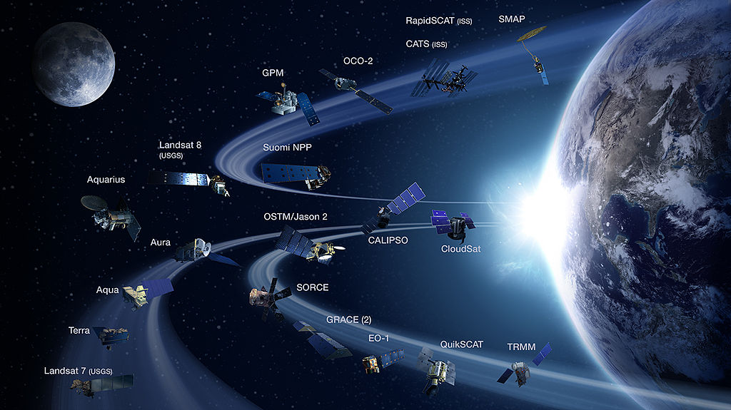
NASA Earth Science Division Operating Missions as of February 2, 2015 - NASA, Public Domain
One key aspect to this system is that each level is cumulative, deriving from the level below it and representing the prerequisite input to the processing needed to reach the level above it. Level 0 data is basically the raw, unprocessed instrument and sensor data. Although at that fundamental level it may be of use to someone who is interested in the calibration and sensitivity of the sensors that collected it, the main utility of level 0 data is as the raw source that is fed to the data processing chain to produce higher level output. Level 1 data can be reversed back to its level 0 state, and is the foundation for all higher level data sets that may be produced.
At level 2, data sets become directly usable for most scientific applications. These data sets may be smaller than the level 1 data that they were derived from as they may have been reduced in some aspect such as spatial extent or spectral range. Level 3 products tend to be smaller still, making them easier to handle, and the regular spatial and temporal organization of these data sets make them appropriate for combining with data from differing sources. Basically, as you go up in processing level, the data sets grow smaller, but their value and utility to scientific applications gets larger.
The advantages of adopting a common set of processing levels to describe the types and degree of processing that an image has had applied to it quickly became clear. The practice seems to have grown to be universally adopted, though many variations do exist. In general, the following definitions are taken to be a standard of sorts:
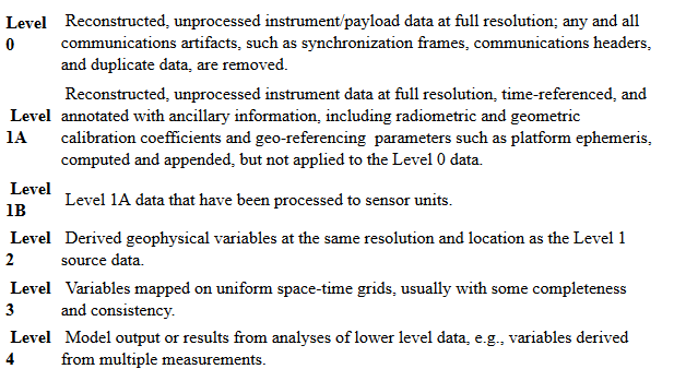
Level 0: Raw instrument data, as collected by the sensor. Data in this state is not terribly useful, unless the focus of interest is the sensing instrument itself rather than the features recorded in the data.
Level 1A: This data has been corrected for variations in detectors across the sensor by applying equalization functions among the detectors, leveling the measurements made by the sensor. This radiometric correction includes absolute calibration coefficients which can then be used to convert the digital numbers into irradiance values.
Level 1B: The next step is to apply measurable corrections to the image to address systematic geometric distortions inherent in the acquisition of the image by some sensors. This level is not necessary for other sensors that don't suffer from such systematic geometric error. Also, note that level 0 data can not be recovered from 1B data.
Level 2A: These images have been systematically mapped into a standard cartographic map reference system. Such products are nominally referred to as being geo-referenced, but do not have a high level of accuracy.
Level 2B: To improve the spatial accuracy of an image, a more rigorous process involving considerable user input is required. Through the process of image rectification, an image analyst geo-registers the image by identifying specific points in the image that correspond to very well-defined geographic locations known as ground control points. With this processing completed, the image is geo-referenced accurately to the spatial resolution of the original data - in other words, limited only by the spatial resolution of the sensor - except in areas of high local topographic relief.
Level 3: In areas with a great deal of elevation relief, such as in mountainous areas, further corrections are required to obtain a more accurate spatial image. Level 3 products have gone through the process of orthorectification, which adjusts the image for distortions due to topographic relief, lens effects, and camera tilt. Level 3 data is uniform in scale and appropriate for use over large grid scales, such as in mosaics.
It is important to note that different systems are in place with different missions and data providers, for various reasons. Landsat 7 designated level 1G as products that are geo-rectified with pixel values in sensor units, for example. DigitalGlobe has an extensive system for categorizing product levels, going from level 1B 'Basic' through level 2A 'Standard' up to various entities such as level 3F (orthorectified imagery with a map accuracy representative fraction of 1:5000) and level Stereo OR2A 'Ortho-ready Standard' - a stereo pair that is ready for the consumer to perform orthorectification on according to their own processes and specifications.