Digital Number, Radiance, and Reflectance
Anonym
Here at NV5 Geospatial Tech Support, we often hear from folks who are confused about exactly what information is stored in the pixel values for their imagery, and how to get from the values they have to the values they need. I thought I'd take a few minutes to clear up some of that confusion.
Digital Number (DN)
The generic term for pixel values is Digital Number or DN. It is commonly used to describe pixel values that have not yet been calibrated into physically meaningful units.
If you just want to look at an image, and don't intend to interpret the pixel values in terms of some physically meaningful, quantitative value like radiance or reflectance (or any value derived from radiance or reflectance values, such as abundance), then it may be just fine to keep your image in its original DN values.
Radiance
Radiance is the amount of radiation coming from an area. To derive a radiance image from an uncalibrated image, a gain and offset must be applied to the pixel values. These gain and offset values are typically retrieved from the image's metadata or received from the data provider. ENVI provides a tool called Radiometric Calibration which will correct DN values to radiance for many data products that are distributed with calibration gain and offset values in the metadata.
There are a number of units that might be used for radiance pixel values, and it is important to understand which units are used for the values in your radiance image. For example, radiance images that are used as input to FLAASH (in ENVI's Atmospheric Correction Module) are expected to have units of µW/(cm2*sr*nm). ENVI's calibration tool allows you to control the units with which your radiance image is output.
Radiance includes radiation reflected from the surface, bounced in from neighboring pixels, and reflected from clouds above the area of the pixel. Radiance is also affected by the source of the radiation, which for optical imagery is the sun. If you look at the spectrum of a radiance pixel, it will have the overall shape of the solar spectrum, which peaks at green wavelengths (about 500 nm).
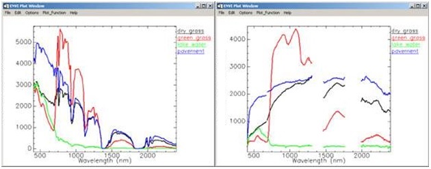
Radiance (left) and surface reflectance (right) spectra for dry grass (black), green grass (red), water(green) and pavement (blue). Notice that all of the radiance spectra trend toward higher values at about 500 nm, because the spectrum of the sun peaks at about 500 nm . The gaps in the reflectance spectra indicate wavelengths at which radiation is strongly absorbed by the atmosphere and so no signal from the surface can be detected. Image courtesy of Spectral Sciences Inc.
Typically, for quantitative analysis of multispectral or hyperspectral image data, radiance images are corrected to reflectance images.
Reflectance
Reflectance is the proportion of the radiation striking a surface to the radiation reflected off of it. Some materials can be identified by their reflectance spectra, so it is common to correct an image to reflectance as a first step toward locating or identifying features in an image.
Top of Atmosphere Reflectance
Top-of-atmosphere reflectance (or TOA reflectance) is the reflectance measured by a space-based sensor flying higher than the earth's atmosphere. These reflectance values will include contributions from clouds and atmospheric aerosols and gases.
Surface Reflectance
Surface Reflectance is the reflectance of the surface of the Earth. Clouds and other atmospheric components do not affect surface reflectance spectra. Typically images of surface reflectance are derived from calibrated radiance images. There are many ways to derive reflectance images from radiance images, including model-based atmospheric corrections such as those included in ENVI's Atmospheric Correction Module.
In summary, it is common to receive an uncalibrated image directly from the data provider, then calibrate it to a radiance image. The radiance image is then atmospherically corrected, resulting in a surface reflectance image. At this point, the reflectance image is ready to be used to extract quantitative information about features on the surface.