From here to there - and everywhere – with Geospatial Cloud Computing
Anonym
In a previous article we presented an overview of the advantages of cloud computing in remote sensing applications, and described an upcoming prototype web application for processing imagery from the HICO sensor on the International Space Station.
First, as a follow up, we’re excited to announce availability of the HICO Image Processing System – a cloud computing platform for on-demand remote sensing image analysis and data visualization.
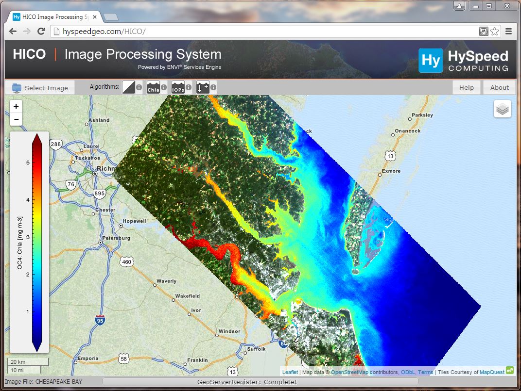
HICO IPS allows users to select specific images and algorithms, dynamically launch analysis routines in the cloud, and then see results displayed directly in an online map interface. System capabilities are demonstrated using imagery collected by the Hyperspectral Imager for the Coastal Ocean (HICO) on the International Space Station, and example algorithms are included for assessing coastal water quality and other near shore environmental conditions.
This is an application-server, and not just a map-server.Thus, HICO IPS is delivering on-demand image processing of real physical parameters, such as chlorophyll concentration, inherent optical properties, and water depth.
The system was developed using a combination of commercial and open-source software, with core image processing performed using the recently released ENVI Services Engine. No specialized software is required to run HICO IPS. You just need an internet connection and a web browser to run the application (we suggest using Google Chrome).
Beyond HICO,and beyond the coastal ocean, the system can be configured for any number of different remote sensing instruments and applications, thus providing an adaptable cloud computing framework for rapidly implementing new algorithms and applications, as well as making these applications and their output readily available to the global user community.
However, this is but one application. Significantly greater work is needed throughout the remote sensing community to leverage these and other exciting new tools and processing capabilities. To participate in a discussion of how the future of geospatial image processing is evolving, and see a presentation of the HICO IPS, join us at the upcoming ENVI Analytics Symposium in Boulder, CO, August 25-26.
With this broader context in mind, and as a second follow-up, we ask the important question when envisioning this future of how we as an industry, and as are search community, are going to get from here to there?
The currently expanding diversity and volume of remote sensing data presents particular challenges for aggregating data relevant to specific research applications, developing analysis tools that can be extended to a variety of sensors, efficiently implementing data processing across a distributed storage network, and delivering value-added products to a broad range of stakeholders.
Based on lessons learned from developing the HICO IPS, here we identify three important requirements needed to meet these challenges:
- Data and application interoperability need to continue evolving.This need speaks to the use of broadly accessible data formats, expansion of software binding libraries, and development of cross-platform applications.
- Improved mechanisms are needed for transforming research achievements into functional software applications. Greater impact can be achieved, larger audiences reached, and application opportunities significantly enhanced, if more investment is made in remote sensing technology transfer.
- Robust tools are required for decision support and information delivery. This requirement necessitates development of intuitive visualization and user interface tools that will assist users in understanding image analysis output products as well as contribute to more informed decision making.
These developments will not happen overnight, but the pace of the industry indicates that such transformations are already in process and that geospatial image processing will continue to evolve at a rapid rate. We encourage you to participate.
--
About HySpeed Computing: Our mission is to provide the most effective analysis tools for deriving and delivering information from geospatial imagery. Visit us at hyspeedcomputing.com.
To access the HICO Image Processing System: https://www.hyspeedcomputing.com/hico-ips.html