X

NV5 Geospatial Blog

Each month, NV5 Geospatial posts new blog content across a variety of categories. Browse our latest posts below to learn about important geospatial information or use the search bar to find a specific topic or author. Stay informed of the latest blog posts, events, and technologies by joining our email list!


From Image to Insight: How GEOINT Automation Is Changing the Speed of Decision-Making

From Image to Insight: How GEOINT Automation Is Changing the Speed of Decision-Making

4/28/2025

When every second counts, the ability to process geospatial data rapidly and accurately isn’t just helpful, it’s critical. Geospatial Intelligence (GEOINT) has always played a pivotal role in defense, security, and disaster response. But in high-tempo operations, traditional workflows are no longer fast enough. Analysts are... Read More >

Thermal Infrared Echoes: Illuminating the Last Gasp of a Dying Star

Thermal Infrared Echoes: Illuminating the Last Gasp of a Dying Star

4/24/2025

This blog was written by Eli Dwek, Emeritus, NASA Goddard Space Flight Center, Greenbelt, MD and Research Fellow, Center for Astrophysics, Harvard & Smithsonian, Cambridge, MA. It is the fifth blog in a series showcasing our IDL® Fellows program which supports passionate retired IDL users who may need support to continue their work... Read More >

A New Era of Hyperspectral Imaging with ENVI® and Wyvern’s Open Data Program

A New Era of Hyperspectral Imaging with ENVI® and Wyvern’s Open Data Program

2/25/2025

This blog was written in collaboration with Adam O’Connor from Wyvern.   As hyperspectral imaging (HSI) continues to grow in importance, access to high-quality satellite data is key to unlocking new insights in environmental monitoring, agriculture, forestry, mining, security, energy infrastructure management, and more.... Read More >

Ensure Mission Success With the Deployable Tactical Analytics Kit (DTAK)

Ensure Mission Success With the Deployable Tactical Analytics Kit (DTAK)

2/11/2025

In today’s fast-evolving world, operational success hinges on real-time geospatial intelligence and data-driven decisions. Whether it’s responding to natural disasters, securing borders, or executing military operations, having the right tools to integrate and analyze data can mean the difference between success and failure.... Read More >

How the COVID-19 Lockdown Improved Air Quality in Ecuador: A Deep Dive Using Satellite Data and ENVI® Software

How the COVID-19 Lockdown Improved Air Quality in Ecuador: A Deep Dive Using Satellite Data and ENVI® Software

1/21/2025

The COVID-19 pandemic drastically altered daily life, leading to unexpected environmental changes, particularly in air quality. Ecuador, like many other countries, experienced significant shifts in pollutant concentrations due to lockdown measures. In collaboration with Geospace Solutions and Universidad de las Fuerzas Armadas ESPE,... Read More >

1345678910Last
«May 2025»
SunMonTueWedThuFriSat
27282930123
45678910
11121314151617
18192021222324
25262728293031
1234567
12089 Rate this article:
4.5

Mapping up-to-date Wildfire Damage with ENVI Analytics

Anonym

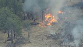
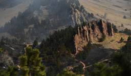
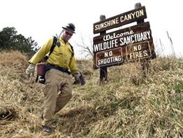
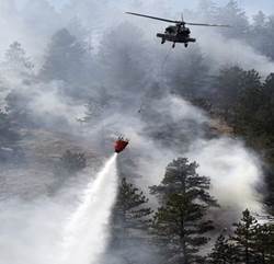
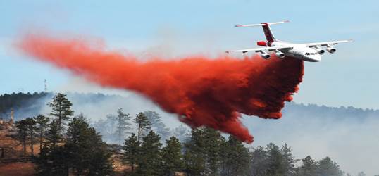
On the morning of Sunday March the 19th, a fire was ignited in the heart of Sunshine Canyon Trail in Boulder, Colorado, causing the evacuating of nearly 426 people and placing another 1,000 on high alert. The fire burned from 1 a.m. early Sunday morning until late Monday night when it was contained and then later died out. Nearly 70 acres of land and forest trails were burned and left black. It was concluded that the fire was caused by transient campers near the Sunshine Canyon Trailhead.


Being a Boulder resident and actually living in the pre-evacuation zone, I did not take this matter lightly. While I was sweating it out, my mind occupied itself with how we could map out this small disaster for government or commercial use. With NV5 Geospatial having a close partnership with Planet, we were able to quickly draw down some RapidEye 5 band satellite imagery of both before and after the fire for immediate fire extent analysis. Below I will walk through steps of how we were able to use our ENVI® analytics with the help of Planets RapidEye imagery to understand the extent of this wildfire only a short time after the disaster occurred.


The first step in our workflow was to get some imagery for before and after of the area that was effected by the fire. Below we have our (Left) pre- and (Right) post- (Right) fire images that have not been processed. As you can see in the two areas highlighted, we have some pre-processing to do. Our area of interest (AOI) for the fire is circled below in blue.


The second step in our workflow is going to be the pre-processing to get rid of some problem areas that may require atmospheric correction. For these datasets, we ran the ENVI Radiometric Correction Quick Atmospheric Correction (QUAC) on a subset of the image so we could focus our analysis only on our AOI. For more specific instruction of how QUAC works, you can visit our help documentation online for a full overview of the tool.

(PrefFire image is on left. Post-fire image is on right).


Next, after we corrected atmospheric distortions in the subset of our data, we ran the data through the ENVI Image Change Workflow. What this does is compares two images of the same geographic extent, taken at different times, and identifies the difference between them based on either a specified input band or on a feature index. With this ENVI workflow, the results are given as either a “gain” or a “loss”. In this instance, we decided to run our workflow on the ENVI Normalized Difference Vegetation Index (NDVI) so that we could extract areas of “loss” due to the fire burning healthy vegetation.

After thresholding our workflow to only include areas of “loss”, and doing some post-processing cleanup, we were able to extract the area of change or “loss” as a shapefile to overlay on top of our original imagery. This gives us a look at the extent of the damage by comparing the before and after imagery. Below we have our subsetted post-fire image with the fire extent shapefile (Left), and subsetted our original pre-fire Image with the fire extent shapefile (Right).


Please login or register to post comments.