X

NV5 Geospatial Blog

Each month, NV5 Geospatial posts new blog content across a variety of categories. Browse our latest posts below to learn about important geospatial information or use the search bar to find a specific topic or author. Stay informed of the latest blog posts, events, and technologies by joining our email list!


Thermal Infrared Echoes: Illuminating the Last Gasp of a Dying Star

Thermal Infrared Echoes: Illuminating the Last Gasp of a Dying Star

4/24/2025

This blog was written by Eli Dwek, Emeritus, NASA Goddard Space flight Center, Greenbelt, MD and Research Fellow, Center for Astrophysics, Harvard & Smithsonian, Cambridge, MA. It is the fifth blog in a series showcasing our IDL® Fellows program which supports passionate retired IDL users who may need support to continue their work... Read More >

A New Era of Hyperspectral Imaging with ENVI® and Wyvern’s Open Data Program

A New Era of Hyperspectral Imaging with ENVI® and Wyvern’s Open Data Program

2/25/2025

This blog was written in collaboration with Adam O’Connor from Wyvern.   As hyperspectral imaging (HSI) continues to grow in importance, access to high-quality satellite data is key to unlocking new insights in environmental monitoring, agriculture, forestry, mining, security, energy infrastructure management, and more.... Read More >

Ensure Mission Success With the Deployable Tactical Analytics Kit (DTAK)

Ensure Mission Success With the Deployable Tactical Analytics Kit (DTAK)

2/11/2025

In today’s fast-evolving world, operational success hinges on real-time geospatial intelligence and data-driven decisions. Whether it’s responding to natural disasters, securing borders, or executing military operations, having the right tools to integrate and analyze data can mean the difference between success and failure.... Read More >

How the COVID-19 Lockdown Improved Air Quality in Ecuador: A Deep Dive Using Satellite Data and ENVI® Software

How the COVID-19 Lockdown Improved Air Quality in Ecuador: A Deep Dive Using Satellite Data and ENVI® Software

1/21/2025

The COVID-19 pandemic drastically altered daily life, leading to unexpected environmental changes, particularly in air quality. Ecuador, like many other countries, experienced significant shifts in pollutant concentrations due to lockdown measures. In collaboration with Geospace Solutions and Universidad de las Fuerzas Armadas ESPE,... Read More >

Rapid Wildfire Mapping in Los Angeles County

Rapid Wildfire Mapping in Los Angeles County

1/14/2025

On January 8, WorldView-3 shortwave infrared (SWIR) imagery captured the ongoing devastation of the wildfires in Los Angeles County. The data revealed the extent of the burned areas at the time of the capture, offering critical insights for rapid response and recovery. To analyze the affected region, we utilized a random forest... Read More >

1345678910Last
«April 2025»
SunMonTueWedThuFriSat
303112345
6789101112
13141516171819
20212223242526
27282930123
45678910
58292 Rate this article:
4.4

Mapping Coastal Erosion Using LiDAR

Anonym

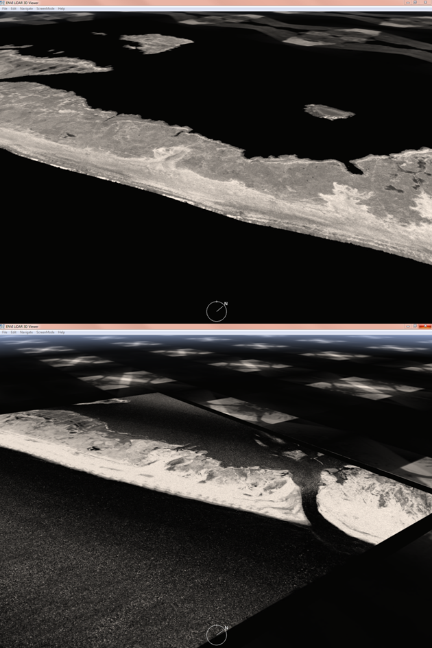
Last week at the Esri UC I spoke on using LiDAR to map coastal erosion in the aftermath of Hurricane Sandy. The area of focus was a section of Fire Island, a barrier Island along the coast of Long Island in New York. According to USGS, Hurricane Sandy caused approximately 30 years worth of coastal damage as it passed up the eastern seaboard, with average dunes erosion in the realm of 22 meters horizontally, and as much as 5 meter losses in elevation in some places.In the study area, the island was breached and a new inlet was created by the pounding wind and waves from the storm. LiDAR provides a great tool for assessing volumetric change over an area, and a combination of ENVI and ENVI LiDAR were used to assess changes in the area. 

The first step was to get some data. The National Centers for Coastal Ocean Science, which is the research office of the NOAA National Ocean Service, was able to provide me with pre and post-event LiDAR coverage of my study area.

Analyze Coastal Erosion with LiDAR
Data courtesy of NOAA

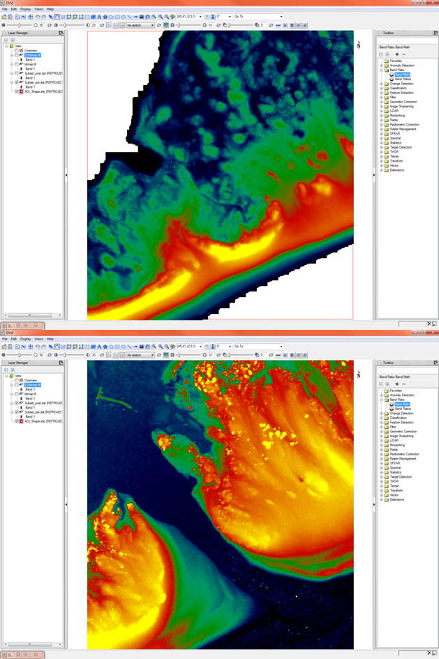
The elevation model was automatically extracted from the point cloud using ENVI LiDAR, then pushed to ENVI and classified by height in an effort to better visualize the change that had taken place and the extent of that change. Below we can see the before and after data sets as classified in ENVI. Note that while the hurricane caused some drastic erosion in the area of the channel, a large amount of sand was also deposited to the sides of the channel as a result from the storm.

Analyze Coastal Erosion with LiDAR
Data courtesy of NOAA

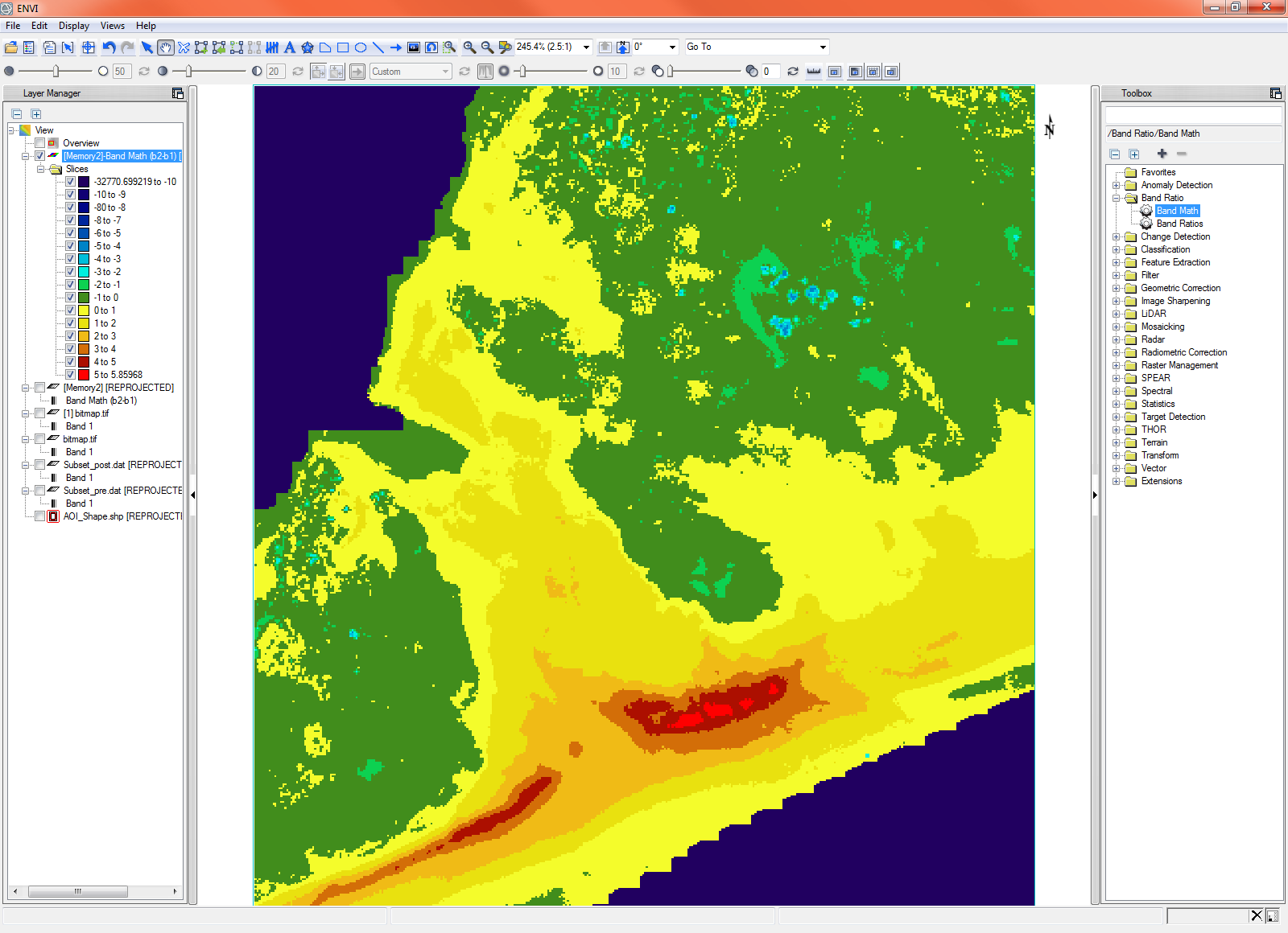
Once the images were classified, a quick band math allowed for a volumetric map of sediment loss in the area by subtracting the height of the after image from the height of the before image. Below is the resulting map depicting the volumetric loss of sediment due to the storm. In this image areas of red and yellow show erosion and areas in green show areas where sediment was deposited.


This kind of a map can be very useful in assessing the amount of sand that has been removed from, or deposited in, an area. This information is very useful for creating recovery plans to repair a damaged area, for developing mitigation plans for this and other similar areas to minimize the impact of erosion due to future events, and to estimate the costs of executing such plans. This kind of map is useful for state and local governments, as well as disaster response teams. 

Analyze Coastal Erosion with LiDAR
Data courtesy of NOAA

How do you use LiDAR? What interesting problems are being solved today with LiDAR that might not have been using it in the past? For more information feel free to contact us.


1 comments on article "Mapping Coastal Erosion Using LiDAR"

Avatar image

Kevin Armstrong

Great analysis. I did something similar for Hurricane Irene looking at the area around Rodanthe, NC. This is great for disaster recovery. To take one more step along this path, I took the resulting volume image and created a model to allow a user to select an area and calculate how many dump trucks would be required to replace the eroded areas. http://charlotte93.esri.com/Irene_Change.png

Please login or register to post comments.