X

NV5 Geospatial Blog

Each month, NV5 Geospatial posts new blog content across a variety of categories. Browse our latest posts below to learn about important geospatial information or use the search bar to find a specific topic or author. Stay informed of the latest blog posts, events, and technologies by joining our email list!


From Image to Insight: How GEOINT Automation Is Changing the Speed of Decision-Making

From Image to Insight: How GEOINT Automation Is Changing the Speed of Decision-Making

4/28/2025

When every second counts, the ability to process geospatial data rapidly and accurately isn’t just helpful, it’s critical. Geospatial Intelligence (GEOINT) has always played a pivotal role in defense, security, and disaster response. But in high-tempo operations, traditional workflows are no longer fast enough. Analysts are... Read More >

Thermal Infrared Echoes: Illuminating the Last Gasp of a Dying Star

Thermal Infrared Echoes: Illuminating the Last Gasp of a Dying Star

4/24/2025

This blog was written by Eli Dwek, Emeritus, NASA Goddard Space Flight Center, Greenbelt, MD and Research Fellow, Center for Astrophysics, Harvard & Smithsonian, Cambridge, MA. It is the fifth blog in a series showcasing our IDL® Fellows program which supports passionate retired IDL users who may need support to continue their work... Read More >

A New Era of Hyperspectral Imaging with ENVI® and Wyvern’s Open Data Program

A New Era of Hyperspectral Imaging with ENVI® and Wyvern’s Open Data Program

2/25/2025

This blog was written in collaboration with Adam O’Connor from Wyvern.   As hyperspectral imaging (HSI) continues to grow in importance, access to high-quality satellite data is key to unlocking new insights in environmental monitoring, agriculture, forestry, mining, security, energy infrastructure management, and more.... Read More >

Ensure Mission Success With the Deployable Tactical Analytics Kit (DTAK)

Ensure Mission Success With the Deployable Tactical Analytics Kit (DTAK)

2/11/2025

In today’s fast-evolving world, operational success hinges on real-time geospatial intelligence and data-driven decisions. Whether it’s responding to natural disasters, securing borders, or executing military operations, having the right tools to integrate and analyze data can mean the difference between success and failure.... Read More >

How the COVID-19 Lockdown Improved Air Quality in Ecuador: A Deep Dive Using Satellite Data and ENVI® Software

How the COVID-19 Lockdown Improved Air Quality in Ecuador: A Deep Dive Using Satellite Data and ENVI® Software

1/21/2025

The COVID-19 pandemic drastically altered daily life, leading to unexpected environmental changes, particularly in air quality. Ecuador, like many other countries, experienced significant shifts in pollutant concentrations due to lockdown measures. In collaboration with Geospace Solutions and Universidad de las Fuerzas Armadas ESPE,... Read More >

1345678910Last
«May 2025»
SunMonTueWedThuFriSat
27282930123
45678910
11121314151617
18192021222324
25262728293031
1234567
15051 Rate this article:
4.1

MIE4NITF: The Newest Standard for Time-Series Enabled NITF Imagery

Jason Wolfe

A greater demand exists within the defense and intelligence community for the ability to view and analyze a time series of images, especially as more UAVs and high-resolution satellites that capture motion imagery become available. Temporal analysis is used in applications such as change detection, tracking patterns and movement, and activity-based intelligence. Having the right software application to process data from the latest motion imagery formats can help to make more informed tactical decisions. ENVI is one of the first commercial software products to support the newest standard, MIE4NITF.

The Motion Imagery Extension for NITF is essentially a container that defines a standard for creating a time series of NITF images. The MIE4NITF standard was developed to combine the rich metadata support in NITF images with time-series information provided by Wide Area Motion Imagery (WAMI) and Full Motion Video (FMV) systems. Modern hardware that collects this type of data will soon exceed the capacity of video standards defined by the Motion Imagery Standards Board (MISB). The MIE4NITF standard allows for greater bit depths, frame sizes, and numbers of bands; in addition to support for multiple cameras and data modalities such as thermal and visible imagery.

ENVI 5.5 Service Pack 1 provides a new menu option: File > Open As > Military Formats > MIE4NITF. Selecting any file from a NITF image collection will open and animate the entire collection in the ENVI Series Manager.

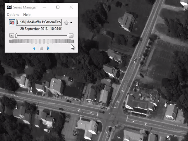
MIE4NITF raster series created from CorvusEye® WAMI data, 07 August 2014, Webster, NY, USA.

An important aspect of working with MIE4NITF is the ability to analyze individual frames, or NITF images. The ENVI Series Manager allows an analyst to load specific images within a series to the ENVI Layer Manager for further analysis. Metadata are encoded as NITF Tagged Record Extensions (TREs). Right-clicking on a single image layer displays the NITF metadata for that image.

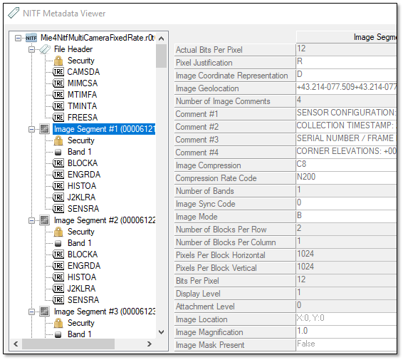
NITF Metadata Viewer in ENVI, showing metadata for a single image segment within a MIE4NITF series.

By combining greater aerial coverage with detailed metadata, MIE4NITF is expected to become the new standard implemented across defense and intelligence agencies.

Please login or register to post comments.