SAR Applications: Now in the Mainstream
Anonym
Reading the free London paper heading into work Monday morning I came upon an article and corresponding satellite image explaining a successful case prosecution evidenced by the image. The case describes the application of satellite imaging used in evidence to prosecute a tanker operator which pleaded guilty to a breach of UK maritime pollution legislation after cleaning palm oil from tanks within a restricted zone (12 miles from the Cornish coast). Nothing strange in that you might say, expect the evidence was a Synthetic Aperture Radar (SAR) image and this is the first time I can recall seeing a SAR image in the mainstream UK press. The case is also deemed a landmark ruling since it represents the first time a satellite image has been used as primary evidence in a maritime pollution case brought by the UK’s Maritime and Coastguard Agency (MCA). MCA benefit from a Europe wide initiative which utilizes a SAR based satellite-based oil spill and vessel detection service collating data from RADARSAT-1 and RADARSAT-2 to provide operational response discharges from ships to participating European member states.
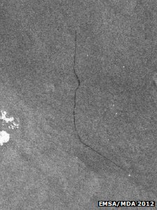
Image © EMSA/MDA 2012. SAR image of the pollution slick, which is approx. 20 miles long
The story brings together several key benefits of SAR in providing assistance in such events. That such a system could not be fulfilled by other forms of remotely sensed data highlights the unique capabilities of SAR systems including: Timeliness – when a possible oil spill is detected, an alert message is delivered to the relevant country. Analyzed images are available to national contact points within just 30 minutes of the satellite passing overhead, in this case allowing the MCA to contact the suspected vessel as the spill event was occurring. Accuracy – SAR can detect even thin oil films, some measuring just micrometers, due to the unique ability to discern surface roughness. Coverage – SAR images are acquired in segments of up to 1 400km and swaths of up to 500km. Swath coverage refers to the width of the strip covered by the radar at each overpass. Persistent Surveillance – the illuminating nature of SAR means it can see through clouds and rain and can be used day or night independently of solar radiation, this gives SAR unmatched persistence coverage capabilities which are particularly important at high latitudes (polar night). Frequency – the frequency of observations for polar orbiting satellites is significantly greater at higher latitudes than at the equator making this system ideal for European operations.
It’s really great to see SAR applications taking their place alongside imagery, GIS and LiDAR as a viable, accessible tool with which to capture, analyze and understand our planet. With ENVI® SARscape integrated within the ENVI platform and extended via ArcGIS we are reaching a stage where SAR image analysis is no longer the domain of experts. This continued adoption of SAR facilitated by straightforward and easy-to-use SAR workflows continues to promote the emergence of the unique capabilities of SAR as an exciting proposition for the geospatial community.