X

NV5 Geospatial Blog

Each month, NV5 Geospatial posts new blog content across a variety of categories. Browse our latest posts below to learn about important geospatial information or use the search bar to find a specific topic or author. Stay informed of the latest blog posts, events, and technologies by joining our email list!


Monitoring Illegal Mining in the Amazon: Turning Persistent Data Into Actionable Insight

Monitoring Illegal Mining in the Amazon: Turning Persistent Data Into Actionable Insight

5/28/2026

Illegal mining over decades has constituted one of the most persistent and complex socio-environmental problems in the Brazilian Amazon. In recent years, with the increasingly intensive use of mechanized extraction, the associated environmental impacts—such as deforestation, intense soil disturbance, river siltation, and mercury... Read More >

From Answers to Action: Why ENVI and IDL Agents Go Beyond General AI

From Answers to Action: Why ENVI and IDL Agents Go Beyond General AI

4/20/2026

As generative AI tools like Claude and Gemini continue to gain traction, many organizations are asking the same question: Can general purpose AI actually support real geospatial workflows, or does it stop at surface-level answers? That question was front and center in our recent webinar, Meet Your New Partners in Science: ENVI... Read More >

Mapping Earthquake Deformation in Taiwan With ENVI

Mapping Earthquake Deformation in Taiwan With ENVI

12/15/2025

Unlocking Critical Insights With ENVI® Tools Taiwan sits at the junction of major tectonic plates and regularly experiences powerful earthquakes. Understanding how the ground moves during these events is essential for disaster preparedness, public safety, and building community resilience. But traditional approaches like field... Read More >

Comparing Amplitude and Coherence Time Series With ICEYE US GTR Data and ENVI SARscape

Comparing Amplitude and Coherence Time Series With ICEYE US GTR Data and ENVI SARscape

12/3/2025

Large commercial SAR satellite constellations have opened a new era for persistent Earth monitoring, giving analysts the ability to move beyond simple two-image comparisons into robust time series analysis. By acquiring SAR data with near-identical geometry every 24 hours, Ground Track Repeat (GTR) missions minimize geometric decorrelation,... Read More >

Empowering D&I Analysts to Maximize the Value of SAR

Empowering D&I Analysts to Maximize the Value of SAR

12/1/2025

Defense and intelligence (D&I) analysts rely on high-resolution imagery with frequent revisit times to effectively monitor operational areas. While optical imagery is valuable, it faces limitations from cloud cover, smoke, and in some cases, infrequent revisit times. These challenges can hinder timely and accurate data collection and... Read More >

1345678910Last
«June 2026»
SunMonTueWedThuFriSat
31123456
78910111213
14151617181920
21222324252627
2829301234
567891011
22583 Rate this article:
5.0

Top Ten Weird Things I’ve Done While Working in Remote Sensing

Anonym

1. Found seals on icebergs. They look big and brown—commas and feature extraction works pretty well.

2. Looked for deer in thermal infrared images, these were still images. The people wanted to find them because the deer were traffic hazards. I guess they were hoping the deer wouldn’t move. At that point in time, after collection, they had to drive the camera data to a lab to analyze it. By the time they returned, the deer weren’t there when they went to look for them.

3. Met the Freedom Rodeo Queen of Lawton, Oklahoma, and her attendant while collecting field spectra for a calibration experiment. Was referred to as “the attendant” the rest of the trip.

4. Observed catfish ponds for algal contamination that can result in “Off Flavor” catfish.

5. Fixed that one troublesome pixel in my vacation photos with ENVI Pixel editor. It’s a darn good thing I didn’t know that existed in grad school. Anyone who has dealt with data that’s as correlated as a shot-gun blast knows what I’m talking about.

6. Threatened a group of tusked pigs with an LAI2000 Plant Canopy Analyzer while on a ground truthing mission in Brazil to verify Landsat and EO-1’s ability to estimate fractional canopy cover. I was told very seriously to urinate on them should I get cornered. In case you didn't notice, my name is Amanda.

7. Told people my spectrometer was a GPS so they’d stop asking questions about why I had a butter churn and was walking around an airport tarmac (pre- 9/11). I was attempting to calibrate Landsat 5.

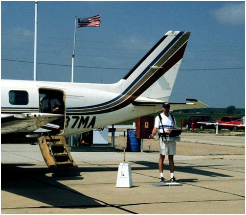
The other “attendant” with butter churn spectrometer

8. Spent time chasing AVIRIS—it’s not as romantic as it sounds.

9. Was taken to many welding shops, pawn shops, gunshops, fireworks stands, and junk yards by an account manager who once said, “I can turn half an hour early into 5 minutes late if you’re not careful”. After these interesting visits, I’d then sitdown and talk very seriously about ENVI/IDL and solving people’s problems with software, not about the items found at the aforementioned places.

10. Was told to degrade good imagery into bad imagery to see if bad imagery would work as well as good imagery.

Please login or register to post comments.