X

NV5 Geospatial Blog

Each month, NV5 Geospatial posts new blog content across a variety of categories. Browse our latest posts below to learn about important geospatial information or use the search bar to find a specific topic or author. Stay informed of the latest blog posts, events, and technologies by joining our email list!


Not All Supernovae Are Created Equal: Rethinking the Universe’s Measuring Tools

Not All Supernovae Are Created Equal: Rethinking the Universe’s Measuring Tools

6/3/2025

Rethinking the Reliability of Type 1a Supernovae   How do astronomers measure the universe? It all starts with distance. From gauging the size of a galaxy to calculating how fast the universe is expanding, measuring cosmic distances is essential to understanding everything in the sky. For nearby stars, astronomers use... Read More >

Using LLMs To Research Remote Sensing Software: Helpful, but Incomplete

Using LLMs To Research Remote Sensing Software: Helpful, but Incomplete

5/26/2025

Whether you’re new to remote sensing or a seasoned expert, there is no doubt that large language models (LLMs) like OpenAI’s ChatGPT or Google’s Gemini can be incredibly useful in many aspects of research. From exploring the electromagnetic spectrum to creating object detection models using the latest deep learning... Read More >

From Image to Insight: How GEOINT Automation Is Changing the Speed of Decision-Making

From Image to Insight: How GEOINT Automation Is Changing the Speed of Decision-Making

4/28/2025

When every second counts, the ability to process geospatial data rapidly and accurately isn’t just helpful, it’s critical. Geospatial Intelligence (GEOINT) has always played a pivotal role in defense, security, and disaster response. But in high-tempo operations, traditional workflows are no longer fast enough. Analysts are... Read More >

Thermal Infrared Echoes: Illuminating the Last Gasp of a Dying Star

Thermal Infrared Echoes: Illuminating the Last Gasp of a Dying Star

4/24/2025

This blog was written by Eli Dwek, Emeritus, NASA Goddard Space Flight Center, Greenbelt, MD and Research Fellow, Center for Astrophysics, Harvard & Smithsonian, Cambridge, MA. It is the fifth blog in a series showcasing our IDL® Fellows program which supports passionate retired IDL users who may need support to continue their work... Read More >

A New Era of Hyperspectral Imaging with ENVI® and Wyvern’s Open Data Program

A New Era of Hyperspectral Imaging with ENVI® and Wyvern’s Open Data Program

2/25/2025

This blog was written in collaboration with Adam O’Connor from Wyvern.   As hyperspectral imaging (HSI) continues to grow in importance, access to high-quality satellite data is key to unlocking new insights in environmental monitoring, agriculture, forestry, mining, security, energy infrastructure management, and more.... Read More >

1345678910Last
6638 Rate this article:
5.0

Using Simulated Data To Train Deep Learning Models

David Starbuck

My colleague, Atle Borsholm, and I had the opportunity to attend the DIRSIG Basic Training in October 2022, hosted by the Rochester Institute of Technology (RIT). DIRSIG, a pioneering technology developed by RIT, offers an innovative solution for generating synthetic remote sensing data. Our goal was to leverage DIRSIG to create training data for deep learning models that can classify real images. Using synthetically created objects to build deep learning models can provide significant cost savings in acquiring imagery for labeling and performing model training. This method opens opportunities to detect features lacking specific training data (such as lacking an object model number or type).

During the training, we also had the privilege to connect with Emily Travinsky of Lockheed Martin, who provided insights into her group's experiments on this subject. The paper for this experiment can be found using the following link:  https://ieeexplore.ieee.org/document/9174596

First Reproduction

We attempted to perform a similar test to Lockheed’s study with some of the following differences:


  1. DIRSIGS’s Chipmaker plugin was used to generate the positive image patches (images with the target object within it)

  2. DIRSIG’s simple atmosphere was used instead of using MODTRAN when generating the patches

  3. Real data patches were used for the negatives (images without the target object within it)

  4. We tested the trained deep learning model using a real scene that was not used as training or validation data as the model was being generated.


The image we were using for the test was a Worldview-3 panchromatic image of an airfield. We created a model to identify the following objects: Tu-160, Tu-95, Misc. Airplanes, and helicopters. We used CAD models of the Tu-160 and Tu-95 aircrafts to generate image chips with these aircrafts. Using the B737, Badger and helicopter models that come with DIRSIG, we generated image chips with these aircraft types. A separate WorldView image was used to generate image chips empty of any aircraft. We used these chips to generate a multiclass Resnet-50 model and used this model to classify patches within the test image. The results are shown below:

 
class ap tp fp fn recall prec F1
Tu-160 9 8 2 1 0.889 0.800 0.842
Tu-95 15 14 2 1 0.933 0.875 0.903
Misc. 23 10 0 13 0.435 1.000 0.606
helicopter 19 17 0 2 0.895 1.000 0.944
total 66 49 4 17 0.742 0.925 0.824

ap - total number of actual positives

tp – true positives

fp – false positives

fn – false negatives

recall – ratio between positives correctly identified and total positives

prec - ratio of true positives and total number of predicted positives (tp/(tp+fp))

F1 – Harmonic mean between recall and precision = 2 / (1/recall + 1/precision)

Even though we used synthetic data for training, the accuracy was over 84% for all of the objects other than miscellaneous planes. The CAD models used to generate the miscellaneous planes most likely did not match the planes in the test image well enough.


Second Reproduction

To increase the visuals that can be shown in this blogpost, we performed a simplified reproduction using NAIP data. Some the differences between this reproduction and the first reproduction are:


  1. Only the B737 CAD model that comes with the DIRSIG was used to generate the positive chips

  2. The classification only determined if a plane was present in a patch or was not present

  3. DIRSIG was used to generate empty chips

  4. ENVI’s Deep Learning module was used to train the model and perform the classification


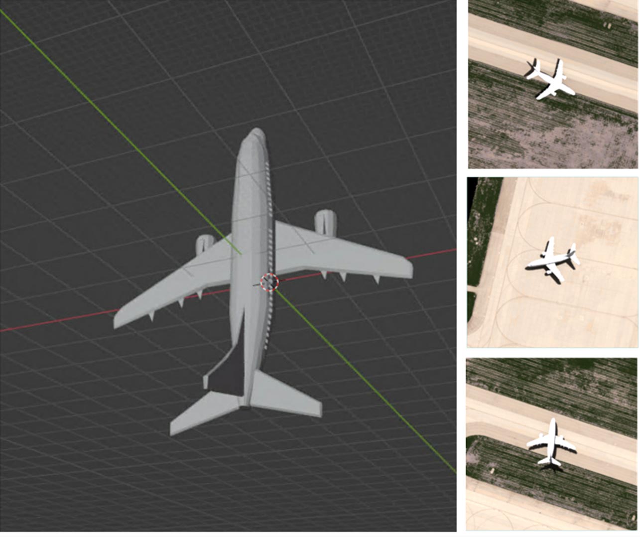
A screenshot of the B737 CAD model as well as a sample of the chips generated by DIRSIG from the model are shown below:


We generated a model using about ~500 positive image chips and ~100 negative image chips to train a “Grid” model using ENVI Deep Learning module. The “Grid” model is a new feature that will be included in the next version of ENVI Deep Learning. The “Grid” will allow users to generate Resnet50 or Resnet101 models. The “Grid” model generates an output grid of positive patches.

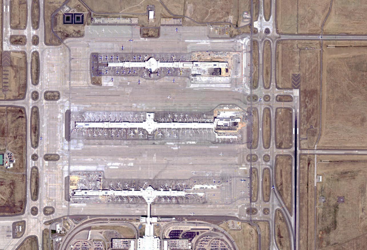
We used a NAIP image of Denver International Airport (DIA) to test the generated model. A sample of the image is shown below:


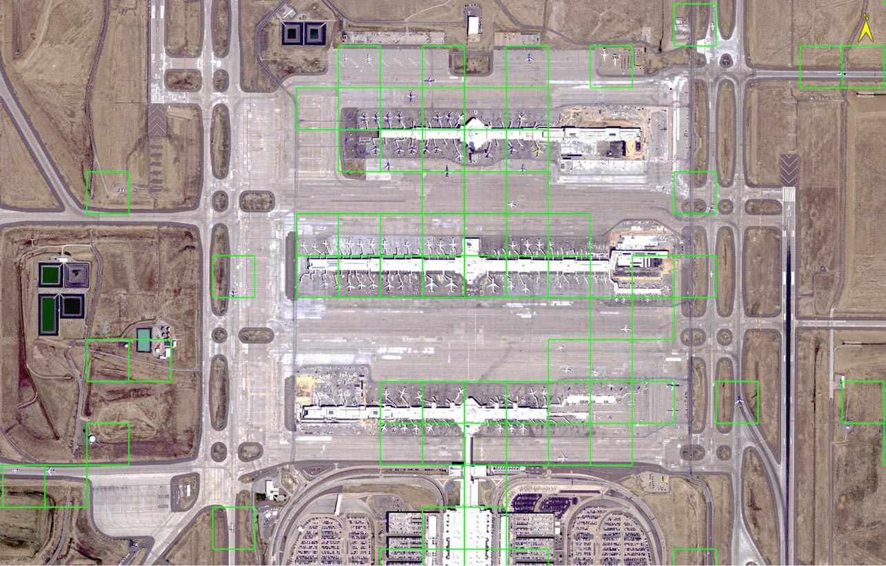
We ran the grid classification on the DIA scene and the output grid is shown below:


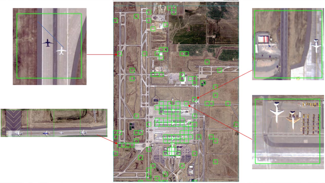
We performed a closer examination of a section of the result that was an area of 13x21 patches (273).


In the image below, true positives are highlighted in green, true negatives are highlighted in blue, false positives are highlighted in orange, and false negatives are highlighted in red.


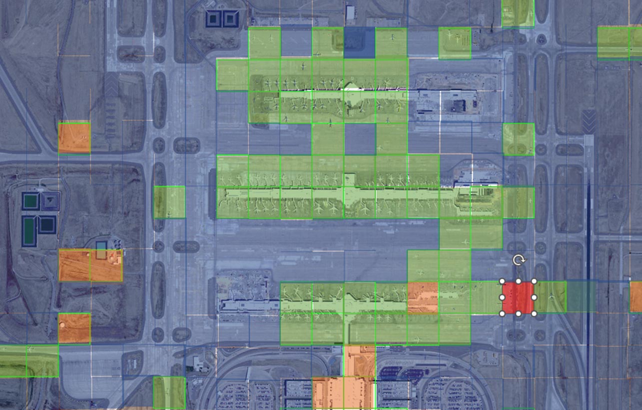
In this section there are 59 true positives, 9 false positives, 1 false negative and 204 true negatives. The accuracy is about 96.3%. This is a very high level of accuracy using a model built with synthetic data on a real image.

The application of using synthetic data to build models has a great deal of value in detecting targets when there simply isn’t sufficient representative training data. Whether you're a researcher, student, or technology enthusiast, the exploration into the world of synthetic remote sensing data promises to be an exciting journey.

Click here to learn more about DIRSIG, and get more detailed information on ENVI Deep Learning here.


DISCOVER MORE

Students, Researchers and Instructors

ACADEMIC SOLUTIONS

Using ENVI and IDL for research and to prepare students for successful careers.

ANSWERS YOU CAN TRUST

ENVI SOFTWARE

Process and analyze all types of imagery and data.

AUTOMATE ANALYTICS

ENVI DEEP LEARNING

Get faster, more accurate results with ENVI Deep Learning.


Please login or register to post comments.