X

NV5 Geospatial Blog

Each month, NV5 Geospatial posts new blog content across a variety of categories. Browse our latest posts below to learn about important geospatial information or use the search bar to find a specific topic or author. Stay informed of the latest blog posts, events, and technologies by joining our email list!


Not All Supernovae Are Created Equal: Rethinking the Universe’s Measuring Tools

Not All Supernovae Are Created Equal: Rethinking the Universe’s Measuring Tools

6/3/2025

Rethinking the Reliability of Type 1a Supernovae   How do astronomers measure the universe? It all starts with distance. From gauging the size of a galaxy to calculating how fast the universe is expanding, measuring cosmic distances is essential to understanding everything in the sky. For nearby stars, astronomers use... Read More >

Using LLMs To Research Remote Sensing Software: Helpful, but Incomplete

Using LLMs To Research Remote Sensing Software: Helpful, but Incomplete

5/26/2025

Whether you’re new to remote sensing or a seasoned expert, there is no doubt that large language models (LLMs) like OpenAI’s ChatGPT or Google’s Gemini can be incredibly useful in many aspects of research. From exploring the electromagnetic spectrum to creating object detection models using the latest deep learning... Read More >

From Image to Insight: How GEOINT Automation Is Changing the Speed of Decision-Making

From Image to Insight: How GEOINT Automation Is Changing the Speed of Decision-Making

4/28/2025

When every second counts, the ability to process geospatial data rapidly and accurately isn’t just helpful, it’s critical. Geospatial Intelligence (GEOINT) has always played a pivotal role in defense, security, and disaster response. But in high-tempo operations, traditional workflows are no longer fast enough. Analysts are... Read More >

Thermal Infrared Echoes: Illuminating the Last Gasp of a Dying Star

Thermal Infrared Echoes: Illuminating the Last Gasp of a Dying Star

4/24/2025

This blog was written by Eli Dwek, Emeritus, NASA Goddard Space Flight Center, Greenbelt, MD and Research Fellow, Center for Astrophysics, Harvard & Smithsonian, Cambridge, MA. It is the fifth blog in a series showcasing our IDL® Fellows program which supports passionate retired IDL users who may need support to continue their work... Read More >

A New Era of Hyperspectral Imaging with ENVI® and Wyvern’s Open Data Program

A New Era of Hyperspectral Imaging with ENVI® and Wyvern’s Open Data Program

2/25/2025

This blog was written in collaboration with Adam O’Connor from Wyvern.   As hyperspectral imaging (HSI) continues to grow in importance, access to high-quality satellite data is key to unlocking new insights in environmental monitoring, agriculture, forestry, mining, security, energy infrastructure management, and more.... Read More >

1345678910Last
15175 Rate this article:
5.0

Imagery of the Month – Fort McMurray Fire Roars On

Anonym

The Fort McMurray Fire is still making headlines and shows no signs of slowing down more than three weeks after it began. The devastating path of the fire has burned over 2018 square miles and destroyed some 2,400 homes and buildings. Wildfire Manager Chad Morrison is expecting weeks, if not months, of fighting the fire as it continues its path North crossing over from Alberta into Saskatchewan. Hot, dry weather conditions combined with only millimeters of moisture on the southern end of the fire haven’t helped containment efforts.

NASA continues to aid the firefighting effort by capturing a vast amount of Imagery over the fire from their Modis, Landsat 8, and Suomi NPP satellites (shown below). The sensors on the satellites allow penetration of the clouds and smoke and make it possible to see hotspots using thermal and IR bands. This helps those managing the firefighting efforts to deploy assets in areas where there are hotspots, regardless of the smoke of cloud coverage. The imagery captured also aides in the recovery efforts and allows the government to widely asses the areas burned and see what has survived the blaze.

Clear weather aligned with Suomi NPP’s flight over Fort McMurray on May 24th giving a spectacular view of the fire. The image shows the sheer size of the burn and the intensity at which it continues to burn.
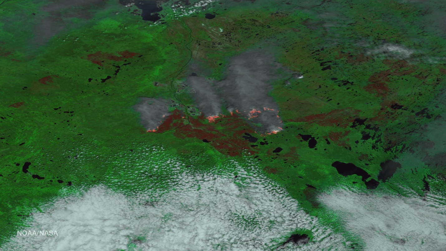
(Credit Nasa/NOAA)

The Image above has been processed, making it easy to identify the burn scar, as well as see where the fire continues to roar near the North side of the scar. Having both thermal and visible imagery makes it possible to classify cloud, smoke, land, and then the active blaze itself.

Though the Suomi Image is my image of the month, there was one additional image from Joshua Stevens at NASA Earth Observatory from May 12th that shows another close perspective from Landsat 8 of the burn scar itself surrounding Fort McMurray and the fire burning to the South/Southwest.

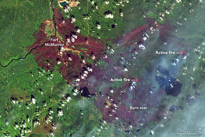
(Credits: NASA EarthObservatory image by Joshua Stevens, using Landsat data from the U.S. Geological Survey)

The contrast of the burn scar and surrounding healthy vegetation shows the extent the fire has scorched this area. Hopefully, additional wildfire crews that have been approved, and cooperating weather, will help get the upper hand on the blaze in the coming weeks. Containing the fire is just the first step in getting the residents of Fort McMurray on the road to rebuilding their town. 


Please login or register to post comments.