X

NV5 Geospatial Blog

Each month, NV5 Geospatial posts new blog content across a variety of categories. Browse our latest posts below to learn about important geospatial information or use the search bar to find a specific topic or author. Stay informed of the latest blog posts, events, and technologies by joining our email list!


Deploy, Share, Repeat: AI Meets the Analytics Repository

Deploy, Share, Repeat: AI Meets the Analytics Repository

10/13/2025

The upcoming release of ENVI® Deep Learning 4.0 makes it easier than ever to import, deploy, and share AI models, including industry-standard ONNX models, using the integrated Analytics Repository. Whether you're building deep learning models in PyTorch, TensorFlow, or using ENVI’s native model creation tools, ENVI... Read More >

Blazing a trail: SaraniaSat-led Team Shapes the Future of Space-Based Analytics

Blazing a trail: SaraniaSat-led Team Shapes the Future of Space-Based Analytics

10/13/2025

On July 24, 2025, a unique international partnership of SaraniaSat, NV5 Geospatial Software, BruhnBruhn Innovation (BBI), Netnod, and Hewlett Packard Enterprise (HPE) achieved something unprecedented: a true demonstration of cloud-native computing onboard the International Space Station (ISS) (Fig. 1). Figure 1. Hewlett... Read More >

NV5 at ESA’s Living Planet Symposium 2025

NV5 at ESA’s Living Planet Symposium 2025

9/16/2025

We recently presented three cutting-edge research posters at the ESA Living Planet Symposium 2025 in Vienna, showcasing how NV5 technology and the ENVI® Ecosystem support innovation across ocean monitoring, mineral exploration, and disaster management. Explore each topic below and access the full posters to learn... Read More >

Monitor, Measure & Mitigate: Integrated Solutions for Geohazard Risk

Monitor, Measure & Mitigate: Integrated Solutions for Geohazard Risk

9/8/2025

Geohazards such as slope instability, erosion, settlement, or seepage pose ongoing risks to critical infrastructure. Roads, railways, pipelines, and utility corridors are especially vulnerable to these natural and human-influenced processes, which can evolve silently until sudden failure occurs. Traditional ground surveys provide only periodic... Read More >

Geo Sessions 2025: Geospatial Vision Beyond the Map

Geo Sessions 2025: Geospatial Vision Beyond the Map

8/5/2025

Lidar, SAR, and Spectral: Geospatial Innovation on the Horizon Last year, Geo Sessions brought together over 5,300 registrants from 159 countries, with attendees representing education, government agencies, consulting, and top geospatial companies like Esri, NOAA, Airbus, Planet, and USGS. At this year's Geo Sessions, NV5 is... Read More >

1345678910Last
«October 2025»
SunMonTueWedThuFriSat
2829301234
567891011
12131415161718
19202122232425
2627282930311
2345678
27822 Rate this article:
No rating

UAV or UAS? The Future of Remote Sensing

Anonym

When thinking about imagery, I am enchanted on a daily basis about how we can utilize technology to capture information we cannot "see". We can then manipulate the information in such a way that something otherwise “invisible” actually becomes obvious. Let’s take a minute to have some fun looking at the obvious. Do these icons look familiar?

Yes, it is a computer mouse that actually looks like a mouse and Kramer’s infamous coffee table book about coffee tables. So what on earth – or more accurately, what in the sky, has sparked my recent inquisition? Checkout Aerovironment’s Nano Hummingbird UAV that looks like (and even moves like) an actual hummingbird:

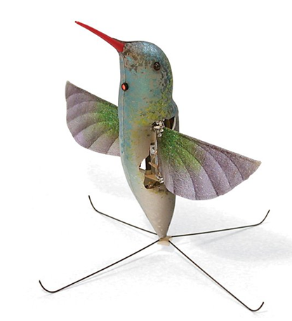
Image recently published in Earth Imaging Journal | Aerovironment site


This month alone there were three articles published in Earth Imaging Journal (EIJ) that touched on various topics related to unmanned aircraft. In fact, according to the article by Michael Hutt from the USGS (USGS UAS Program Does More with Less) the unmanned aircraft integration into the national airspace system (NAS) will create more than 70,000 new US jobs and grow the market segment to $13.6 billion within three years of integration. Recent influx of UAV applications in the news, industry journals, and even from my customers, supports this growth theory as do the rapid advances in technical capabilities of these small ‘birds’.

While we are on the cusp of a new era in remote sensing technology, the terminology is still catching up and has yet to completely work itself out. If you Google UAV vs. UAS you will quickly find that there has been a great debate about which term is “correct” and how these acronyms may become distinguished from one another in the near future.

UAV or UAS?

What is most similar between the two and also what distinguishes these aircraft from remote control planes is that these aircraft have pilots at a ground station in continuous control of the vehicle at all times. This is true whether the aircraft can be seen from the ground or not. So what distinguishing features separate a UAV from a UAS?

According to the Association for Unmanned Aerial Vehicle Systems International (AUVSI), a UAV incorporates “…lightweight airframes, advanced propulsion systems, secure data links, and high technology control systems and payloads.”

As the industry moves forward the platform itself is rapidly becoming distinguished from the advanced aspects of deployment and compliance requirements with NAS regulations. Compliance will be greatly dependent upon the ability to implement safety regulations. Tasks such as radio communication, capture systems, and even implementation of sense-and-avoid technologies will be controlled at these ground stations. Thus the “S” in UAS encompasses the system in its entirety.

I am personally excited to follow and learn how the UAS industry continues to evolve and look forward to the opportunity to work on more UAS applications. Will you be using an unmanned aircraft in the future?

1 comments on article "UAV or UAS? The Future of Remote Sensing"

Avatar image

lopuu

It is nice playing rc planes, and its my hobby too since i was in 12 yrs old. This is a good project for all rc plane collectors in which they can donate some charities to less fortunate people. tiger coupons

Please login or register to post comments.