X

NV5 Geospatial Blog

Each month, NV5 Geospatial posts new blog content across a variety of categories. Browse our latest posts below to learn about important geospatial information or use the search bar to find a specific topic or author. Stay informed of the latest blog posts, events, and technologies by joining our email list!


NV5 at ESA’s Living Planet Symposium 2025

NV5 at ESA’s Living Planet Symposium 2025

9/16/2025

We recently presented three cutting-edge research posters at the ESA Living Planet Symposium 2025 in Vienna, showcasing how NV5 technology and the ENVI® Ecosystem support innovation across ocean monitoring, mineral exploration, and disaster management. Explore each topic below and access the full posters to learn... Read More >

Monitor, Measure & Mitigate: Integrated Solutions for Geohazard Risk

Monitor, Measure & Mitigate: Integrated Solutions for Geohazard Risk

9/8/2025

Geohazards such as slope instability, erosion, settlement, or seepage pose ongoing risks to critical infrastructure. Roads, railways, pipelines, and utility corridors are especially vulnerable to these natural and human-influenced processes, which can evolve silently until sudden failure occurs. Traditional ground surveys provide only periodic... Read More >

Geo Sessions 2025: Geospatial Vision Beyond the Map

Geo Sessions 2025: Geospatial Vision Beyond the Map

8/5/2025

Lidar, SAR, and Spectral: Geospatial Innovation on the Horizon Last year, Geo Sessions brought together over 5,300 registrants from 159 countries, with attendees representing education, government agencies, consulting, and top geospatial companies like Esri, NOAA, Airbus, Planet, and USGS. At this year's Geo Sessions, NV5 is... Read More >

Not All Supernovae Are Created Equal: Rethinking the Universe’s Measuring Tools

Not All Supernovae Are Created Equal: Rethinking the Universe’s Measuring Tools

6/3/2025

Rethinking the Reliability of Type 1a Supernovae   How do astronomers measure the universe? It all starts with distance. From gauging the size of a galaxy to calculating how fast the universe is expanding, measuring cosmic distances is essential to understanding everything in the sky. For nearby stars, astronomers use... Read More >

Using LLMs To Research Remote Sensing Software: Helpful, but Incomplete

Using LLMs To Research Remote Sensing Software: Helpful, but Incomplete

5/26/2025

Whether you’re new to remote sensing or a seasoned expert, there is no doubt that large language models (LLMs) like OpenAI’s ChatGPT or Google’s Gemini can be incredibly useful in many aspects of research. From exploring the electromagnetic spectrum to creating object detection models using the latest deep learning... Read More >

1345678910Last
«September 2025»
SunMonTueWedThuFriSat
31123456
78910111213
14151617181920
21222324252627
2829301234
567891011
15089 Rate this article:
5.0

Using Deep Learning for Feature Extraction

Anonym

In August, I talked about how to pull features out of images using known spatial properties about an object. Specifically, in that post, I used rule-based feature extraction to pull stoplights out of an image.

Today, I’d like to look in to a new way of doing feature extraction using deep learning technology. With our deep learning tools developed here in house, we can use examples of target data in order to find other similar objects in other images.

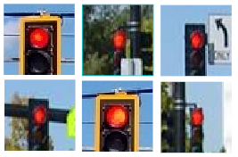
In order to train the system, we will need 3 different kinds of examples for the deep learning network to learn what to look for. This will be target, non-target, and confusers. These examples are patches cut out of similar images, and the patches will all be the same size. In my case for this exercise, I've picked a size of 50 by 50 pixels.

The first patch type is actual target data – I’ll be looking for illuminated traffic lights. For the model to work well, we’ll need different kinds of traffic signals, lightning conditions, and camera angles. This will help the network generalize what the object looks like.

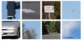
Next, we’ll need negative data, or data that does not contain the object. This will be the areas surrounding the target, and other features that will possibly appear in the background of the image. In our case for traffic lights, this will include cars, streetlights, road signs, foliage, and others.

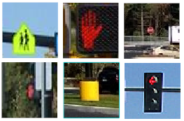
For the final patch type, I went through some images and marked things that may confuse the system. These are called confusers, and will be objects with a similar size, color, and/or shape of the target. In our case, this could be other signals like red arrows or a “don’t walk” hand. I’ve also included some bright road signs and a distant stop sign.

Once we have all of these patches, we can use our machine learning tool known as MEGA to train a neural network that can be used to identify similar objects in other images.

Do note that I have many more patches created than just the ones displayed. With more examples, and more diverse examples, MEGA has a better chance of accurately classifying target vs non-target in an image.

In our case here, we’ll only have three possible outcomes as we look though the image. This will be lights, not lights, and looks-like-a-light classes. If you have many different objects in your scene, you can even get something more like a classification image, as MEGA can be used to identify as many objects in an image as you like. If we wanted to extend this idea here, we could look for red lights, green lights, street lights, lane markers, or other cars. (This is a simple example of how deep learning would be used in autonomous cars!)

To learn more about MEGA and what it can do in your analysis stack, contact our Custom Solutions Group for more details! For my next post, we’ll look at the output from the trained neural network, and analyze the results.

Please login or register to post comments.