Why do the water column vapor amounts returned from FLAASH differ from the published values?
In order to calculate apparent surface reflectance, FLAASH solves the radiative transfer equation by determining the column water vapor amount for each pixel in the image. However, this calculation requires specific narrow spectral bands to be present in the dataset which are often not available with multispectral datasets. In these cases, water retrieval is not possible so a constant column water vapor amount for all pixels in the image is used based on the selected Atmospheric Model, multiplied by an optional water column multiplier. A table of Atmospheres are described in the Atmospheric Correction Module ->Using FLAASH documentation of the ENVI on-line help system.
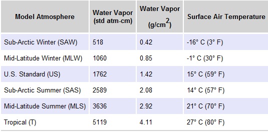
The above table provides water vapor amounts typical for each Model Atmosphere type and are measured from sea level to space. These values are used in the FLAASH calculations for reflectance when water retrieval is not possible. In addition, a multiplier can be used to customize the amount of water vapor used in the equation.
After a FLAASH run, you are presented with a dialog indicating the visibility and average water amount used for the atmospheric correction.
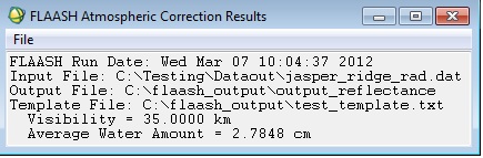
Oftentimes, the returned Average Water Amount from FLAASH does not match the value specified in the above table (with or without the multiplier). So why is there a discrepancy between the selected atmosphereic water amount and that returned by FLAASH?
In the above example, the atmosphere selected was Mid-Latitude Summer with no Water Column Multiplier, so the Average Water Amount used by FLAASH would be 2.92 g/cm2. However, this amount is the estimated amount of water from sea-level to space. If a ground elevation is specified in the input FLAASH parameters that is above 0 km (sea-level), then the amount of water in the atmosphere is adjusted for the ground elevation automatically, thus returning a different amount of water vapor in the atmosphere than what is specified in the documentation. This should provide the best estimate of the atmospheric column water vapor amount when appropriate spectral bands are not present in the data.
Review on 12/31/2013 MM