Meeting the Challenge of Extreme Weather & Climate Monitoring
Anonym
I want to talk about the weather, and not only because it’s a national pastime for us Brits (and so nicely fits the stereotype) but because it’s getting weird.
2013 saw some of the most extreme weather experienced in decades. It was the 7th hottest year on record and featured one of the strongest cyclones ever recorded. Some of the longest and most prolonged heat waves culminated in Australia’s hottest ever year (fully 12 of the 14 hottest years on record are from this millennium). In the UK we experienced the wettest ever recorded summer in 2012, followed record lows in March 2013 and then series of high intensity gales coupled to storm surge tides resulting in widespread flooding towards the end of 2013 and into 2014. Our headquarters in Boulder, Colorado saw an average year of rain fall within just one week in September 2013 causing deaths, mass evacuations and the loss of hundreds of homes and businesses, and as we moved into 2014, Midwest, North-East and Southern US states were gripped by cold weather reaching -30C in places. The cumulative effect of an estimated 1.5 million weather related accidents each year in the US alone results in approximately 700,000 injuries, 7000 deaths and $42B in economic costs.
The trend for increased change is set to continue. Towards the end of 2013 scientists reported how new climate models taking greater account of cloud changes indicate heating will be at the higher end of expectations with predictions that the planet is likely to warm by 4C by 2100 resulting in greater climate instability and increased exceptional weather events. The debate around the anthropogenic impact on climate change continues and how effectively a causal link can be established between this and the frequency of extreme weather continues to be an area of intense investigation. Where all parties can agree is the need to promote improved understanding, monitoring, assessment and response to the effects of extreme weather events. Earth Observation and Remote Sensing play a key role in mitigating social, economic and environmental impacts of linked effects and here ENVI and IDL have a long and successful history.
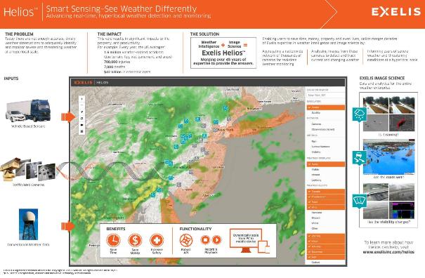
NV5 (formerly Exelis) is proud to deliver solutions which help scientists study climate trends and forecast weather conditions through extensive system, sensor and analytical support as well as driving awareness and understanding. Examples include The Global Precipitation Measurement (GPM) mission, where IDL underpins radar systems providing next-generation global observations of rain and snow, further examples include Solar wind visualization at NOAA and Storm Tracking for the Applied Physics Laboratory. In other areas, ENVI, ENVI SARscape, and ENVI Deep Learning deliver solutions to facilitate the passage of ships through sea ice, map wildfire extent, facilitate flood detection, and identify damaged buildings from tornado. Most recently NV5 innovated again delivering Helios, a new approach to the challenge of identifying and monitoring severe and threatening weather at a hyperlocal scale by applying NV5 image science to an aggregated network of thousands of cameras across the United States.
As we understand more about our changing environment demand for robust tools to meet the needs of both the scientific community and specific consumers of weather and climate data continue to grow, and NV5 look forward to future collaborations and developments in this most important field.