This task separates a raster into a specified number of tiles in the X and Y direction. You can optionally create a vector shapefile that shows the tile boundaries.
Example
e = ENVI()
File = Filepath('qb_boulder_msi', Subdir=['data'], $
Root_Dir=e.Root_Dir)
Raster = e.OpenRaster(File)
Task = ENVITask('DiceRasterByTileCount')
Task.INPUT_RASTER = Raster
Task.NUMBER_OF_X_TILES = 4
Task.NUMBER_OF_Y_TILES = 3
Task.TILE_GRID_VECTORS = 'true'
Task.OUTPUT_DIRECTORY = Filepath('', /TMP)
Task.Execute
DataColl = e.Data
DataColl.Add, Task.OUTPUT_RASTER
View1 = e.GetView()
FOR i=0,N_Elements(Task.Output_Raster)-1 DO $
Layer = View1.CreateLayer(Task.OUTPUT_RASTER[i])
vectorLayer = View1.CreateLayer(Task.OUTPUT_VECTOR)
View1.Zoom, /FULL_EXTENT
Syntax
Result = ENVITask('DiceRasterByTileCount')
Input parameters (Set, Get): INPUT_RASTER, NUMBER_OF_X_TILES, NUMBER_OF_Y_TILES, OUTPUT_DIRECTORY, TILE_GRID_VECTORS
Output parameters (Get only): OUTPUT_RASTER, OUTPUT_VECTOR
Parameters marked as "Set" are those that you can set to specific values. You can also retrieve their current values any time. Parameters marked as "Get" are those whose values you can retrieve but not set.
Input Parameters
Output Parameters
Methods
Execute
Parameter
ParameterNames
Properties
DESCRIPTION
DISPLAY_NAME
NAME
REVISION
TAGS
INPUT_RASTER (required)
Specify the input raster.
NUMBER_OF_X_TILES (required)
Specify the number of resulting tiles in the X direction.
NUMBER_OF_Y_TILES (required)
Specify the number of resulting tiles in the Y direction.
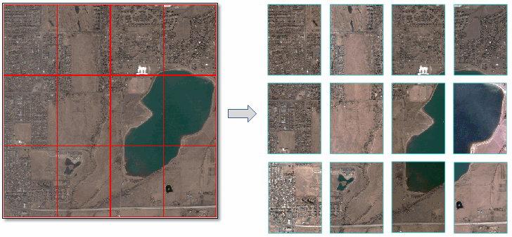
Example: The input image in the code example above has 1024 rows and 1024 columns. The example specifies 4 tiles in the X direction and 3 tiles in the Y direction. Since 1024 is divisible by both 3 and 4, the resulting tiles are equally sized (X: 256, Y: 342).
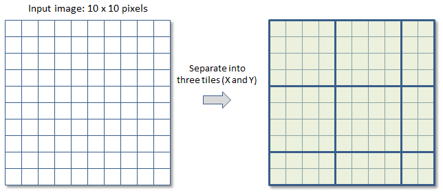
In most cases, the number of pixels (in both directions) will not be divisible by the specified number of tiles. For example, suppose that an image has 10 rows and 10 columns and you want to separate it into 3 tiles in the X and Y directions. Since 10 divided by 3 is 3.333, ENVI rounds up to the nearest integer (4) when creating the tiles. The last tile in each column and row will have smaller dimensions. The following figure shows how the tiles are created:
OUTPUT_DIRECTORY (optional)
Specify the output directory for the tiles. If set to an asterisk (*), the output rasters will be virtual. This will not be written to disk, and the directory will not be created. If you do not set this parameter, the tiles will save to the directory indicated by the ENVI Output Directory preference.
OUTPUT_RASTER
This parameter contains an array of output rasters. Their filenames contain the root name of the input raster with the row/column index appended in the form of RxCx. For example, R2C3 means row 2 and column 3.
OUTPUT_VECTOR
This parameter contains the output shapefile if you set the TILE_GRID_VECTORS parameter to true.
TILE_GRID_VECTORS (optional)
Set this parameter to true to create an output shapefile that shows the tile boundaries.
Version History
|
ENVI 5.4 |
Introduced |
|
ENVI 5.5 |
OUTPUT_DIRECTORY now supports '*', which allows OUTPUT_RASTER to be virtual output.
|
See Also
ENVITask, ENVITask::Parameter, ENVISubsetRaster, CreateSubrectsFromDistance Task, CreateSubrectsFromPixels Task, CreateSubrectsFromTileCount Task, CreateSubrectsFromVector Task, DiceRasterByDistance Task, DiceRasterBySubrects Task, DiceRasterByPixel Task, DiceRasterByVector Task, ExportRastersToDirectory Task