This task separates a raster into tiles based on the spatial extent of individual vector records. The number of resulting tiles will be equal to the number of separate vector records.
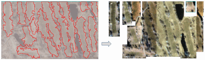
Example
e = ENVI()
File = Filepath('qb_boulder_msi', Subdir=['data'], $
Root_Dir=e.Root_Dir)
Raster = e.OpenRaster(File)
File = Filepath('qb_boulder_msi_vectors.shp', Subdir=['data'], $
Root_Dir=e.Root_Dir)
Vector = e.OpenVector(File)
Task = ENVITask('DiceRasterByVector')
Task.INPUT_RASTER = Raster
Task.INPUT_VECTOR = Vector
Task.OUTPUT_DIRECTORY = Filepath('', /TMP)
Task.Execute
DataColl = e.Data
DataColl.Add, Task.Output_Raster
View1 = e.GetView()
for i=0,N_Elements(Task.Output_Raster)-1 do $
Layer = View1.CreateLayer(Task.Output_Raster[i])
View1.Zoom, /FULL_EXTENT
Syntax
Result = ENVITask('DiceRasterByVector')
Input parameters (Set, Get): INPUT_RASTER, INPUT_VECTOR, OUTPUT_DIRECTORY
Output parameters (Get only): OUTPUT_RASTER
Parameters marked as "Set" are those that you can set to specific values. You can also retrieve their current values any time. Parameters marked as "Get" are those whose values you can retrieve but not set.
Input Parameters
INPUT_RASTER (required)
Specify the input raster.
INPUT_VECTOR (required)
Specify the input vector shapefile that will be used to tile the input raster.
OUTPUT_DIRECTORY (optional)
Specify the output directory for the tiles. If set to an asterisk (*), the output rasters will be virtual. This will not be written to disk, and the directory will not be created. If you do not set this parameter, the tiles will save to the directory indicated by the ENVI Output Directory preference.
Output Parameters
OUTPUT_RASTER
This parameter contains an array of output rasters. Their filenames contain the root name of the input raster with "Areaxx" appended, where xx is the vector record number.
Methods
Execute
Parameter
ParameterNames
Properties
DESCRIPTION
DISPLAY_NAME
NAME
REVISION
TAGS
Version History
|
ENVI 5.4 |
Introduced |
|
ENVI 5.5 |
OUTPUT_DIRECTORY now supports '*', which allows OUTPUT_RASTER to be virtual output.
|
See Also
ENVITask, ENVITask::Parameter, ENVISubsetRaster, CreateSubrectsFromDistance Task, CreateSubrectsFromPixels Task, CreateSubrectsFromTileCount Task, CreateSubrectsFromVector Task, DiceRasterByDistance Task, DiceRasterByPixel Task, DiceRasterBySubrects Task, DiceRasterByTileCount Task, ExportRastersToDirectory Task