This task uses the pushbroom model to filter the tie points. Both input images must contain an RPC spatial reference.
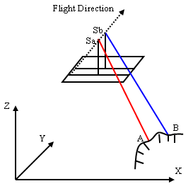
For images taken with a pushbroom sensor that have RPC information, the images of the same scene are related by epipolar geometry constraint. For a feature point in the first image, the corresponding point in the second image must lie on the epipolar line or curve. Both images must have RPCs. Imagery from pushbroom sensors use the line central projection. Each scan line has its own projection center, as the following figure shows.
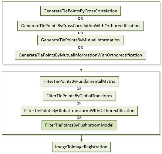
The following diagram shows where this task belongs within an image-to-image registration workflow:
References:
Jin, Xiaoying. ENVI automated image registration solutions. NV5 Geospatial Solutions, Inc. whitepaper (2017). ENVI automated image registration solutions can be downloaded from our website.
Jin, Xiaoying, and Robert Schafer. Method and system for automatic registration of images. Exelis, Inc., assignee; now owned by NV5 Global, Inc. U.S. Patent No. 9,245,201 (issued January 26, 2016).
Example
This example uses sample Quickbird images and a USGS SRTM 1-arc second DEM. The files are available from our ENVI Tutorials web page. Click the Image Registration link to download the .zip file to your machine, then unzip the files. Update the file references in the example with the correct locations.
e = ENVI()
file1 = 'QuickBirdPhoenixWest.dat'
raster1 = e.OpenRaster(file1)
file2 = 'QuickBirdPhoenixEast.dat'
raster2 = e.OpenRaster(file2)
DEMFile = 'PhoenixDEMSubset.dat'
DEMRaster = e.OpenRaster(DEMFile)
Task = ENVITask('GenerateTiePointsByCrossCorrelationWithOrthorectification')
Task.INPUT_RASTER1 = raster1
Task.INPUT_RASTER2 = raster2
Task.INPUT_DEM_RASTER = DEMRaster
Task.REQUESTED_NUMBER_OF_TIEPOINTS = 40
Task.Execute
TiePoints = Task.OUTPUT_TIEPOINTS
OrthoTiePoints = Task.OUTPUT_ORTHORECTIFIED_TIEPOINTS
FilterTask = ENVITask('FilterTiePointsByPushbroomModel')
FilterTask.INPUT_TIEPOINTS = TiePoints
FilterTask.Execute
FilteredTiePoints = FilterTask.OUTPUT_TIEPOINTS
RegTask = ENVITask('ImageToImageRegistration')
RegTask.INPUT_TIEPOINTS = FilteredTiePoints
RegTask.WARPING = 'Triangulation'
RegTask.Execute
WarpedRaster = RegTask.OUTPUT_RASTER
DataColl = e.Data
DataColl.Add, WarpedRaster
View = e.GetView()
Layer = View.CreateLayer(WarpedRaster)
Syntax
Result = ENVITask('FilterTiePointsByPushbroomModel')
Input parameters (Set, Get): INPUT_TIEPOINTS, OUTPUT_TIEPOINTS_URI, REPROJECTION_ERROR_THRESHOLD
Output parameters (Get only): OUTPUT_TIEPOINTS
Parameters marked as "Set" are those that you can set to specific values. You can also retrieve their current values any time. Parameters marked as "Get" are those whose values you can retrieve but not set.
Input Parameters
OUTPUT_TIEPOINTS_URI (optional)
Specify a string with the fully qualified path and filename for OUTPUT_TIEPOINTS.
REPROJECTION_ERROR_THRESHOLD (optional)
Specify the reprojection error threshold to use. Specify the reprojection error threshold to use. It is defined as the perpendicular distance (in pixel units) of a point in one image from its corresponding epipolar line computed from a point in another image. The default value is 10.0.
Output Parameters
OUTPUT_TIEPOINTS
This is a reference to an ENVITiePointSet object with the output tie points.
Methods
Execute
Parameter
ParameterNames
Properties
DESCRIPTION
DISPLAY_NAME
NAME
REVISION
TAGS
INPUT_TIEPOINTS (optional)
This is a reference to the ENVITiePointSet object generated from the GenerateTiePointsByCrossCorrelation or GenerateTiePointsByMutualInformation task.
Version History
See Also
ENVITask, FilterTiePointsByFundamentalMatrix Task, FilterTiePointsByGlobalTransform Task, GenerateTiePointsByCrossCorrelation Task, GenerateTiePointsByMutualInformation Task, ImageToImageRegistration Task, ENVITiePointSet