This task performs automatic tie point generation using cross correlation as a similarity measure. At least one input raster must have an RPC spatial reference. This method works well for general purposes, especially registering images with similar modality (e.g., registering optical images with optical images).
A DEM raster is required to perform orthorectification on-the-fly to geometrically correct the data before image matching.The higher the resolution and accuracy of the DEM data, the more tie points that are generated, and the better the distribution of those points.
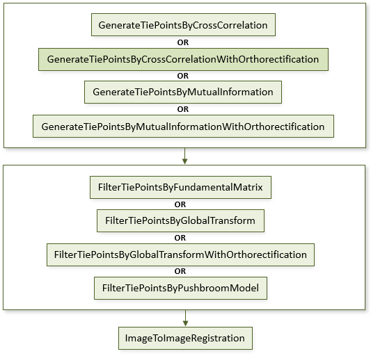
The following diagram shows where this task belongs within an image-to-image registration workflow:
References:
Jin, Xiaoying. ENVI automated image registration solutions. NV5 Geospatial Solutions, Inc. whitepaper (2017). ENVI automated image registration solutions can be downloaded from our website.
Jin, Xiaoying, and Robert Schafer. Method and system for automatic registration of images. Exelis, Inc., assignee; now owned by NV5 Global, Inc. U.S. Patent No. 9,245,201 (issued January 26, 2016).
Example
This example uses sample Quickbird images and a USGS SRTM 1-arc second DEM. The files are available from our ENVI Tutorials web page. Click the Image Registration link to download the .zip file to your machine, then unzip the files. Update the file references in the example with the correct locations.
e = ENVI()
file1 = 'QuickBirdPhoenixWest.dat'
raster1 = e.OpenRaster(file1)
file2 = 'QuickBirdPhoenixEast.dat'
raster2 = e.OpenRaster(file2)
DEMFile = 'PhoenixDEMSubset.dat'
DEMRaster = e.OpenRaster(DEMFile)
Task = ENVITask('GenerateTiePointsByCrossCorrelationWithOrthorectification')
Task.INPUT_RASTER1 = raster1
Task.INPUT_RASTER2 = raster2
Task.INPUT_DEM_RASTER = DEMRaster
Task.REQUESTED_NUMBER_OF_TIEPOINTS = 40
Task.Execute
TiePoints = Task.OUTPUT_TIEPOINTS
OrthoTiePoints = Task.OUTPUT_ORTHORECTIFIED_TIEPOINTS
FilterTask = ENVITask('FilterTiePointsByGlobalTransformWithOrthorectification')
FilterTask.INPUT_TIEPOINTS = TiePoints
FilterTask.INPUT_ORTHORECTIFIED_TIEPOINTS = OrthoTiePoints
FilterTask.Execute
FilteredTiePoints = FilterTask.OUTPUT_TIEPOINTS
RegTask = ENVITask('ImageToImageRegistration')
RegTask.INPUT_TIEPOINTS = FilteredTiePoints
RegTask.WARPING = 'Triangulation'
RegTask.Execute
WarpedRaster = RegTask.OUTPUT_RASTER
DataColl = e.Data
DataColl.Add, WarpedRaster
View = e.GetView()
Layer = View.CreateLayer(WarpedRaster)
Syntax
Result = ENVITask('GenerateTiePointsByCrossCorrelationWithOrthorectification')
Input parameters (Set, Get): INPUT_DEM_RASTER, INPUT_RASTER1, INPUT_RASTER2, INPUT_SEED_TIEPOINTS, INTEREST_OPERATOR, MATCHING_WINDOW, MINIMUM_MATCHING_SCORE, NO_GEOID_CORRECTION, OUTPUT_ORTHORECTIFIED_TIEPOINTS_URI, OUTPUT_TIEPOINTS_URI, REQUESTED_NUMBER_OF_TIEPOINTS, SEARCH_WINDOW
Output parameters (Get only): MATCHING_SCORES, OUTPUT_ORTHORECTIFIED_TIEPOINTS, OUTPUT_TIEPOINTS
Parameters marked as "Set" are those that you can set to specific values. You can also retrieve their current values any time. Parameters marked as "Get" are those whose values you can retrieve but not set.
Input Parameters
INPUT_DEM_RASTER (required)
Specify a DEM raster. At least one input raster must have an RPC spatial reference. Image templates are orthorectified to geometrically correct the data before image matching.
INPUT_RASTER1 (required)
Specify the first raster.
INPUT_RASTER2 (required)
Specify the second raster.
INPUT_SEED_TIEPOINTS (optional)
This is a reference to an ENVITiePointSet object with input seed tie points.
INTEREST_OPERATOR (optional)
Specify the interest operator to use to identify feature points. The default value is Forstner.
- Forstner: Obtains and analyzes the gray scale gradient matrix between one pixel and its adjacent pixels. The Forstner operator is typically better for image matching than the Moravec operator.
- Moravec: Seearches for gray scale value differences between one pixel and its adjacent pixels. The Moravec operator is typically faster than the Forstner operator.
- Harris: Improves upon Moravec by using the auto-correlation matrix and avoids using discrete directions and shifts.
MATCHING_WINDOW (optional)
Specify the matching window size used for computing the matching score between the two images. The default value is 61.
MINIMUM_MATCHING_SCORE (optional)
Specify the minimum matching score to automatically remove the tie points if the matching score is less than the value. The default value is 0.6. To register images with different modalities (e.g., registering SAR with optical images), set the minimum matching score to a lower value.
NO_GEOID_CORRECTION (optional)
Set this to true if the DEM represents ellipsoid height and no geoid correction is needed. The default value is false.
OUTPUT_ORTHORECTIFIED_TIEPOINTS_URI (optional)
Specify a string with the fully-qualified path and filename for OUTPUT_ORTHORECTIFIED_TIEPOINTS.
OUTPUT_TIEPOINTS_URI (optional)
Specify a string with the fully qualified path and filename for OUTPUT_TIEPOINTS.
REQUESTED_NUMBER_OF_TIEPOINTS (optional)
Specify the requested number of tie points. The default value is 121.
SEARCH_WINDOW (optional)
Specify the tolerance for the search range. The default value is 255.
Output Parameters
MATCHING_SCORES
The normalized cross-correlation between the matching windows (specified with the MATCHING_WINDOW parameter) in both input images is computed as the matching score. This value is a double-precision array in the form [number of tie points].
This is an advanced parameter designed for users who want more control over filtering tie points by matching scores. See Example: Matching Scores in the ENVIGenerateTiePointsByCrossCorrelation topic for a code example.
OUTPUT_ORTHORECTIFIED_TIEPOINTS
This is a reference to the output orthorectified tie points.
OUTPUT_TIEPOINTS
This is a reference to an ENVITiePointSet object with the output tie points.
Methods
Execute
Parameter
ParameterNames
Properties
DESCRIPTION
DISPLAY_NAME
NAME
REVISION
TAGS
Version History
See Also
ENVITask, GenerateTiePointsByMutualInformationWithOrthorectification Task, FilterTiePointsByGlobalTransformWithOrthorectification Task, FilterTiePointsByFundamentalMatrix Task, FilterTiePointsByPushbroomModel Task, ImageToImageRegistration Task, ENVITiePointSet