This task constructs an ENVIRaster from an array of source rasters that overlap or contain gaps in coverage. The individual rasters are tiled into one virtual raster.
The most common use for this function is with QuickBird images in DigitalGlobe tiled format (*.til) that overlap in coverage. When you use File > Open to select a .til file in the user interface, ENVI automatically assembles the tiles to construct a virtual raster. However, the BuildIrregularGridMetaspatialRaster task was designed to give ENVI programmers control over the offsets and tile sizes needed to construct a virtual raster from individual source rasters.
The virtual raster associated with this task is ENVIIrregularGridMetaspatialRaster.
Example
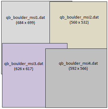
This example creates a metaspatial raster from four source rasters. The source files are available from our ENVI Tutorials web page. Click the API Gridding Examples link to download the .zip file to your machine, then unzip the files. Update the file references in the example with the correct locations.
Each source raster overlaps the others. The metaspatial raster created in this example will have a fixed tile size of 512 x 512 pixels:
e = ENVI()
offsets = LonArr(2,2,2)
file1 = 'qb_boulder_msi1.dat'
raster1 = e.OpenRaster(file1)
offsets[0,0,0] = 0
offsets[0,0,1] = 0
file2 = 'qb_boulder_msi2.dat'
raster2 = e.OpenRaster(file2)
offsets[1,0,0] = 464
offsets[1,0,1] = 0
file3 = 'qb_boulder_msi3.dat'
raster3 = e.OpenRaster(file3)
offsets[0,1,0] = 10
offsets[0,1,1] = 399
file4 = 'qb_boulder_msi4.dat'
raster4 = e.OpenRaster(file4)
offsets[1,1,0] = 425
offsets[1,1,1] = 453
sourceRasters = [[raster1, raster2], [raster3, raster4]]
tileSize = [512,512]
Task = ENVITask('BuildIrregularGridMetaspatialRaster')
Task.INPUT_RASTERS = sourceRasters
Task.OFFSETS = offsets
Task.TILE_SIZE = tileSize
Task.Execute
DataColl = e.Data
DataColl.Add, Task.OUTPUT_RASTER
View = e.GetView()
Layer = View.CreateLayer(Task.OUTPUT_RASTER)
View.Zoom, /FULL_EXTENT
Syntax
Result = ENVITask('BuildIrregularGridMetaspatialRaster')
Input parameters (Set, Get): DATA_IGNORE_VALUE, INPUT_RASTERS, OUTPUT_RASTER_URI, SPATIAL_REFERENCE
Output parameters (Get only): OUTPUT_RASTER
Parameters marked as "Set" are those that you can set to specific values. You can also retrieve their current values any time. Parameters marked as "Get" are those whose values you can retrieve but not set.
Input Parameters
DATA_IGNORE_VALUE (optional)
Specify a unique data value for pixels in the output raster that have a non-zero pixel state value. Pixels from empty tiles will have a non-zero pixel state value.
INPUT_RASTERS (required)
Specify a 2D array of input ENVIRasters that may contain overlaps and gaps. Each tile of the output raster will be cropped or padded to fit the tile size. The following rules apply:
- Source rasters must have the same number of bands.
- Specify empty tiles with null objects by calling the IDL Obj_New routine instead of using ENVIRasters.
- Padded and empty tiles will have PIXEL_STATE set to 2 (No Data). The pixel data will be invalid in these areas. If you need to export the raster to disk, provide a data ignore value.
- Metadata values are passed from the source rasters to the virtual raster only if the values are the same in all source rasters.
- Source rasters do not need to be georeferenced. If the top-left tile contains a spatial reference, that reference will be used for the virtual raster. You can override the spatial reference by using the SPATIALREF keyword.
-
The order of the array elements determines the layout of the tiles in the metaspatial raster. Here are some examples:
SourceRasters = [raster1, raster2, raster3, raster4]
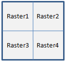
SourceRasters = [[raster1, raster2], [raster3, raster4]]
[[raster1], [raster2], [raster3], [raster4]]
OFFSETS (required)
Offsets are zero-based pixel coordinates that represent the top-left corner of each raster with respect to the top-left corner of the metaspatial raster. Specify an m x n x 2 array of offsets corresponding to the m x n array of source rasters, along with a column and row offset for each array.
For example, the layout of source rasters in the code example above is specified with a 2 x 2 array:
sourceRasters = [[raster1, raster2], [raster3, raster4]]
Offsets is a 2 x 2 x 2 array in this case. To further illustrate this example, the offsets for the upper-right image (raster2) are as follows:
offsets[1,0,0] = 464
offsets[1,0,1] = 0
Where:
- [1,0,0] is the array index for the column, and 464 is its offset value
- [1,0,1] is the array index for the row, and 0 is its offset value.
This means that pixel location (464,0) in raster2 will be the upper-right corner of the associated tile in the virtual raster.
OUTPUT_RASTER_URI (optional)
Specify a string with the fully qualified filename and path to export the associated OUTPUT_RASTER.
- If you set this parameter to an asterisk symbol (*), the output raster will be virtual and not written to disk.
- If you do not specify this parameter, or set it to an exclamation symbol (!), a temporary file will be created.
- If you set it to the hash symbol (#), ENVI creates a file in the temporary directory, but this file will not be deleted when ENVI closes.
SPATIAL_REFERENCE (optional)
Set this parameter to an ENVIStandardRasterSpatialRef, ENVIPseudoRasterSpatialRef, or ENVIRPCRasterSpatialRef object to be used by OUTPUT_RASTER. If this is not specified, then the SPATIALREF parameter of the first raster in the INPUT_RASTERS array will be used, if possible. If that raster is a NullObject, or if it does not have a SPATIALREF value, then OUTPUT_RASTER will not have any spatial reference associated with it.
TILE_SIZE (required)
Specify a 2D array indicating the desired size of each tile, in number of pixels. Use this convention: [xSize, ySize]. Each source raster will be cropped or padded with "no data" values to fit the tile size.
Output Parameters
OUTPUT_RASTER
This is a reference to the output raster of filetype ENVI.
Methods
Execute
Parameter
ParameterNames
Properties
DESCRIPTION
DISPLAY_NAME
NAME
REVISION
TAGS
Version History
|
ENVI 5.2.1 |
Introduced |
|
ENVI 5.5 |
OUTPUT_RASTER_URI now supports '*', which allows OUTPUT_RASTER to be virtual output.
INPUT_RASTERS allows NullObject values in array of ENVIRasters.
Add DATA_IGNORE_VALUE, so that exported raster will have correct pixel state.
|
See Also
ENVITask, ENVISubsetRaster, ENVIIrregularGridMetaspatialRaster, ENVIMetaspatialRaster, BuildMetaspatialRaster Task, Masking Support in ENVITasks