This task uses the global transform to filter the tie points. For orthorectified images, nadir, or near-nadir images, the transformation model between the first image and the second image fits an RST transform. When the scene is rather flat and the sensor is very far from the scene, the transformation model between the two images fits a first-order polynomial transform. Global transform is the most common filtering method.
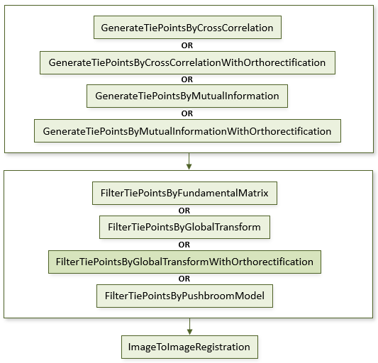
The following diagram shows where this task belongs within an image-to-image registration workflow:
References:
Jin, Xiaoying. ENVI automated image registration solutions. NV5 Geospatial Solutions, Inc. whitepaper (2017). ENVI automated image registration solutions can be downloaded from our website.
Jin, Xiaoying, and Robert Schafer. Method and system for automatic registration of images. Exelis, Inc., assignee; now owned by NV5 Global, Inc. U.S. Patent No. 9,245,201 (issued January 26, 2016).
Example
This example uses sample Quickbird images and a USGS SRTM 1-arc second DEM. The files are available from our ENVI Tutorials web page. Click the Image Registration link to download the .zip file to your machine, then unzip the files. Update the file references in the example with the correct locations.
e = ENVI()
file1 = 'QuickBirdPhoenixWest.dat'
raster1 = e.OpenRaster(file1)
file2 = 'QuickBirdPhoenixEast.dat'
raster2 = e.OpenRaster(file2)
DEMFile = 'PhoenixDEMSubset.dat'
DEMRaster = e.OpenRaster(DEMFile)
Task = ENVITask('GenerateTiePointsByCrossCorrelationWithOrthorectification')
Task.INPUT_RASTER1 = raster1
Task.INPUT_RASTER2 = raster2
Task.INPUT_DEM_RASTER = DEMRaster
Task.REQUESTED_NUMBER_OF_TIEPOINTS = 40
Task.Execute
TiePoints = Task.OUTPUT_TIEPOINTS
OrthoTiePoints = Task.OUTPUT_ORTHORECTIFIED_TIEPOINTS
FilterTask = ENVITask('FilterTiePointsByGlobalTransformWithOrthorectification')
FilterTask.INPUT_TIEPOINTS = TiePoints
FilterTask.INPUT_ORTHORECTIFIED_TIEPOINTS = OrthoTiePoints
FilterTask.Execute
FilteredTiePoints = FilterTask.OUTPUT_TIEPOINTS
RegTask = ENVITask('ImageToImageRegistration')
RegTask.INPUT_TIEPOINTS = FilteredTiePoints
RegTask.WARPING = 'Triangulation'
RegTask.Execute
WarpedRaster = RegTask.OUTPUT_RASTER
DataColl = e.Data
DataColl.Add, WarpedRaster
View = e.GetView()
Layer = View.CreateLayer(WarpedRaster)
Syntax
Result = ENVITask('FilterTiePointsByGlobalTransformWithOrthorectification')
Input parameters (Set, Get): ERROR_THRESHOLD, FITTING_TRANSFORM, INPUT_ORTHORECTIFIED_TIEPOINTS, INPUT_TIEPOINTS, OUTPUT_TIEPOINTS_URI
Output parameters (Get only): OUTPUT_TIEPOINTS
Parameters marked as "Set" are those that you can set to specific values. You can also retrieve their current values any time. Parameters marked as "Get" are those whose values you can retrieve but not set.
Input Parameters
ERROR_THRESHOLD (optional)
Specify the maximum error to allow for each tie point. The tie point with the largest error distance from the predicted location is iteratively removed until no tie points have an error greater than the this value. A first-order polynomial transform or RST transform is used to compute the predicted location from tie points on the first image to the points on the second image. The ERROR measurement represents the distance of each tie point in the second image to its predicted location, in pixel units. If at least one input image or warp image have RPC spatial reference and you specified a DEM file, ENVI performs an on-the-fly orthorectification on the input image(s) for geometric filtering by global transform, resulting in a more accurate image registration.
The default value is 5.0. A higher value keeps more tie points with larger fitting errors. If you prefer to keep most tie points, enter a high value such as 100.
FITTING_TRANSFORM (optional)
Specify the transform to use when automatically filtering tie points. The default is First-Order Polynomial.
- First-Order Polynomial: A first-order polynomial warp includes an XY interaction term to account for image shear.
- RST: Rotation, scaling, and translation; this is the simplest method. It does not allow for shearing in the image warp.
INPUT_ORTHORECTIFIED_TIEPOINTS (required)
This is a reference to the orthorectified tie points generated by the GenerateTiePointsByCrossCorrelationWithOrthorectification or GenerateTiePointsByMutualInformationWithOrthorectification task.
INPUT_TIEPOINTS (required)
This is a reference to an ENVITiePointSet object.
OUTPUT_TIEPOINTS_URI (optional)
Specify a string with the fully qualified path and filename for OUTPUT_TIEPOINTS.
Output Parameters
OUTPUT_TIEPOINTS
This is a reference to an ENVITiePointSet object with the output tie points.
Methods
Execute
Parameter
ParameterNames
Properties
DESCRIPTION
DISPLAY_NAME
NAME
REVISION
TAGS
Version History
See Also
ENVITask, GenerateTiePointsByMutualInformationWithOrthorectification Task, GenerateTiePointsByCrossCorrelationWithOrthorectification Task, ImageToImageRegistration Task, ENVITiePointSet