You can display map boundaries such as continents, countries, states, rivers and lakes on a map or map projection. The following examples show the basics of how to use the MAPCONTINENTS function to display these boundaries.
Polar Map Showing Continents and Countries
The code shown below creates the polar map shown above. You can copy the entire block and paste it into the IDL command line to run it.
ant_map = MAP('STEREOGRAPHIC', $
CENTER_LATITUDE=-90, $
CENTER_LONGITUDE=0, $
FILL_COLOR='Light Blue')
conts = MAPCONTINENTS(/COUNTRIES, FILL_COLOR='beige')
Limited-Area Map Showing Countries and Rivers
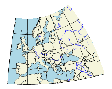
The code shown below creates the graphic shown above. You can copy the entire block and paste it into the IDL command line to run it.
map = MAP('STEREOGRAPHIC', FILL_COLOR = 'Light Blue', $
LIMIT = [30.0, -15.0, 68.0, 55.0])
mc = MAPCONTINENTS(/COUNTRIES, FILL_COLOR='beige')
rivers = MAPCONTINENTS(/RIVERS, COLOR='blue')
Resources