You can enhance map graphics by overplotting contour data to show more detail. In this topic, we will use the IMAGE function along with the CONTOUR function using global cloud data.
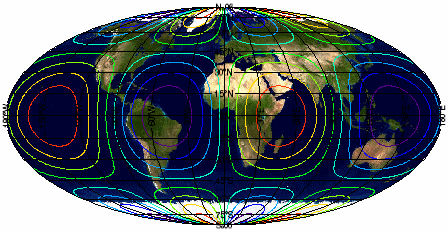
The code shown below creates the graphic shown above. You can copy the entire block and paste it into the IDL command line to run it.
READ_JPEG, FILEPATH('Day.jpg', $
SUBDIR=['examples','data']), daymap
longitude = FINDGEN(360) - 180
latitude = FINDGEN(180) - 90
cntrdata = SIN(longitude/30) # COS(latitude/30)
map2 = IMAGE(daymap, $
LIMIT=[-90,-180,90,180], GRID_UNITS=2, $
IMAGE_LOCATION=[-180,-90], IMAGE_DIMENSIONS=[360,180],$
MAP_PROJECTION='Mollweide')
cntr2 = CONTOUR(cntrdata, longitude, latitude, $
GRID_UNITS=2, N_LEVELS=10, RGB_TABLE=34, /OVERPLOT)
Resources