The example below shows how to display a digital elevation model (DEM) on an image and display it as a three-dimensional globe.
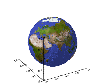
The code shown below creates the graphic shown above. Copy the code below and paste it into a new file in the IDL editor, then compile and run it.
PRO WORLD_SURF
OPENR, lun, FILEPATH('worldelv.dat', $
SUBDIR = ['examples', 'data']), /GET_LUN
elev = BYTARR(360, 360)
READU, lun, elev
FREE_LUN, lun
elev = SHIFT(elev, 180)
zscale = 0.05
a = 360L
b = 360L
n = a * b
spherical = MAKE_ARRAY(3, n, /DOUBLE)
FOR i = 0L, a - 1 DO BEGIN
FOR j = 0L, b - 1 DO BEGIN
k = ( i * b ) + j
spherical[0, k] = j * 360.0 / (a - 1)
spherical[1, k] = i * 180.0 / (b - 1) - 90.0
spherical[2, k] = 1.0 + zscale * elev[k] / 255.0
ENDFOR
ENDFOR
rectangular = CV_COORD(FROM_SPHERE = spherical, /TO_RECT, /DEGREES)
z = REFORM( rectangular[2, *], a, b )
x = REFORM( rectangular[0, *], a, b )
y = REFORM( rectangular[1, *], a, b )
im = read_png(FILEPATH('avhrr.png', SUBDIR = ['examples', 'data']), r, g, b)
image = BYTARR(3, 720, 360)
IMAGE[0, *, *] = r[im]
IMAGE[1, *, *] = g[im]
IMAGE[2, *, *] = b[im]
s = SURFACE(z, x, y, TEXTURE_IMAGE = image, LOCATION = [0, 0], aspect_z=1.0)
END
Resources