ENVI provides the following indices that measure miscellaneous features:
Modified Normalized Difference Water Index (MNDWI)
This index enhances open water features while suppressing noise from built-up land, vegetation, and soil. Xu (2006) reported that the MNDWI produced better results than the Normalized Difference Water Index (McFeeters 1996) in enhancing and extracting water from a background that is dominated by build-up land areas.
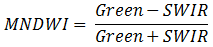
Here are some guidelines for interpreting MNDWI results:
- Open water has greater positive values than NDWI, as it absorbs more shortwave-infrared (SWIR) wavelengths than near-infrared (NIR) wavelengths.
- Built-up features have negative values.
- Soil and vegetation have negative values, as soil reflects more SWIR wavelengths than NIR wavelengths.
The MNDWI was originally developed for use with Landsat TM bands 2 and 5. However, it will work with any multispectral sensor with a green band between 0.5-0.6 µm and a SWIR band between 1.55-1.75 µm.
References:
Xu, H. "Modification of Normalised Difference Water Index (NDWI) to Enhance Open Water Features in Remotely Sensed Imagery." International Journal of Remote Sensing 27, No. 14 (2006): 3025-3033.
McFeeters, S. "The use of Normalized Difference Water Index (NDWI) in the Delineation of Open Water Features." International Journal of Remote Sensing 17 (1996): 1425-1432.
Normalized Difference Built-Up Index (NDBI)
This index highlights urban areas where there is typically a higher reflectance in the shortwave-infrared (SWIR) region, compared to the near-infrared (NIR) region. Applications include watershed runoff predictions and land-use planning.
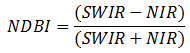
The NDBI was originally developed for use with Landsat TM bands 5 and 4. However, it will work with any multispectral sensor with a SWIR band between 1.55-1.75 µm and a NIR band between 0.76-0.9 µm.
Reference: Zha, Y., J. Gao, and S. Ni. "Use of Normalized Difference Built-Up Index in Automatically Mapping Urban Areas from TM Imagery." International Journal of Remote Sensing 24, no. 3 (2003): 583-594.
Normalized Difference Mud Index (NDMI)
This index highlights muddy or shallow water pixels. This index was originally designed as a filter to exclude those pixels and to improve the accuracy of QUick Atmospheric Correction (QUAC).
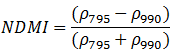
See Narrowband Definitions for the allowable range of wavelengths.
Reference: Bernstein, L. S., X. Jin, B. Gregor, and S. Adler-Golden. "Quick Atmospheric Correction Code: Algorithm Description and Recent Upgrades." Optical Engineering 51, No. 11 (2012): 111719-1 to 111719-11.
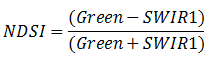
Normalized Difference Snow Index (NDSI)
This index highlights snow cover using a combination of visible (typically green) and shortwave-infrared wavelengths. This version of NDSI was originally designed for use with MODIS bands 4 (0.555 µm) and 6 (1.64 µm). However, it will work with any multispectral sensor with a green band ranging from 0.5 to 0.6 µm and a SWIR1 band ranging from 1.55 to 1.75 µm.
References:
Hall, D., G. Riggs, and V. Salomonson. "Development of Methods for Mapping Global Snow Cover Using Moderate Resolution Imaging Spectroradiometer Data." Remote Sensing of Environment 54, No. 2 (1995): 127-140.
Salomonson, V., and I. Appel. "Estimating Fractional Snow Cover from MODIS Using the Normalized Difference Snow Index." Remote Sensing of Environment 89 (2004): 351-360.
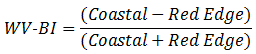
WorldView Built-Up Index (WV-BI)
This index uses WorldView-2 bands to compute a Normalized Difference Built-Up Index (NDBI).
WorldView Non-Homogeneous Feature Difference (WV-NHFD)
This index uses WorldView-2 bands to identify features that contrast highly against the background. Examples include roofs, vehicles, and paved surfaces.
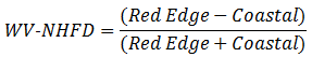
Reference: Wolf, A. Using WorldView 2 Vis-NIR MSI Imagery to Support Land Mapping and Feature Extraction Using Normalized Difference Index Ratios. Unpublished report, Longmont, CO: DigitalGlobe (2010).
WorldView Water Index (WV-WI)
This index uses WorldView-2 bands to highlight areas of standing water greater than one pixel in size.
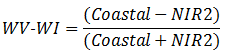
Reference: Wolf, A. Using WorldView 2 Vis-NIR MSI Imagery to Support Land Mapping and Feature Extraction Using Normalized Difference Index Ratios. Unpublished report, Longmont, CO: DigitalGlobe (2010).
See Also
Spectral Indices