The canopy water content VIs provide a measure of the amount of water contained in the foliage canopy. Water content is an important quantity of vegetation because higher water content indicates healthier vegetation that is likely to grow faster and be more fire-resistant. Canopy water content VIs use reflectance measurements in the near-infrared and shortwave infrared regions to take advantage of known absorption features of water and the penetration depth of light in the near-infrared region to make integrated measurements of total column water content.
Disease Water Stress Index (DWSI)
This index detects water-stressed crops at a canopy level.
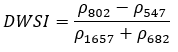
Reference: Galvao, L. S., et al. "Discrimination of sugarcane varieties in Southeastern Brazil with EO-1 Hyperion data." Remote Sensing of Environment 94 (2005): 523-534.
Leaf Water Vegetation Index 1 (LWVI1)
This index estimates leaf water content, an NDWI variant.
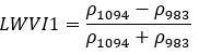
Reference: Galvao, L. S., et al. "Discrimination of sugarcane varieties in Southeastern Brazil with EO-1 Hyperion data." Remote Sensing of Environment 94 (2005): 523-534.
Leaf Water Vegetation Index 2 (LWVI2)
This index estimates leaf water content, an NDWI variant.
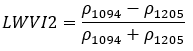
Reference: Galvao, L. S., et al. "Discrimination of sugarcane varieties in Southeastern Brazil with EO-1 Hyperion data." Remote Sensing of Environment 94 (2005): 523-534.
Moisture Stress Index (MSI)
This index is a reflectance measurement that is sensitive to increasing leaf water content. As the water content of leaves in vegetation canopies increases, the strength of the absorption around 1599 nm increases. Absorption at 819 nm is nearly unaffected by changing water content, so it is used as the reference. Applications include canopy stress analysis, productivity prediction and modeling, fire hazard condition analysis, and studies of ecosystem physiology. The MSI is inverted relative to the other water VIs; higher values indicate greater water stress and less water content.
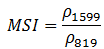
The value of this index ranges from 0 to more than 3. The common range for green vegetation is 0.4 to 2. See Narrowband Definitions for the allowable range of wavelengths.
References:
Hunt Jr., E., and B. Rock. "Detection of Changes in Leaf Water Content Using Near- And Middle-Infrared Reflectances." Remote Sensing of Environment 30 (1989): 43-54.
Ceccato, P., et al. "Detecting Vegetation Leaf Water Content Using Reflectance in the Optical Domain." Remote Sensing of Environment 77 (2001): 22-33.
Normalized Difference Infrared Index (NDII)
This index is a reflectance measurement that is sensitive to changes in water content of plant canopies. The NDII uses a normalized difference formulation instead of a simple ratio, and the index values increase with increasing water content. Applications include crop agricultural management, forest canopy monitoring, and vegetation stress detection.
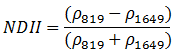
The value of this index ranges from -1 to 1. The common range for green vegetation is 0.02 to 0.6. See Narrowband Definitions for the allowable range of wavelengths.
References:
Hardisky, M., V. Klemas, and R. Smart. "The Influences of Soil Salinity, Growth Form, and Leaf Moisture on the Spectral Reflectance of Spartina Alterniflora Canopies." Photogrammetric Engineering and Remote Sensing 49 (1983): 77-83.
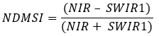
Normalized Difference Moisture Index (NDMSI)
This index is used to determine vegetation water content. It is calculated as a ratio between the NIR and SWIR values in traditional fashion.
Landsat Spectral Indices products courtesy of the U.S. Geological Survey Earth Resources Observation and Science Center.
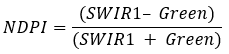
Normalized Difference Pond Index (NDPI)
This index helps differentiate between vegetation and ponds, and is targeted to add contrast when there is vegetation in ponds.
Reference: Lacaux, J.P., Tourre, Y.M., Vignolles, C., Ndione, J.A. and Lafaye, M. (2007) "Classification of Ponds from High-Spatial Resolution Remote Sensing: Application to Rift Valley Fever Epidemics in Senegal." Remote Sensing of Environment, 106, 66-74.
Normalized Difference Water Index (NDWI)
This index is sensitive to changes in vegetation canopy water content because reflectance at 857 nm and 1241 nm has similar but slightly different liquid water absorption properties. The scattering of light by vegetation canopies enhances the weak liquid water absorption at 1241 nm. Applications include forest canopy stress analysis, leaf area index studies in densely foliated vegetation, plant productivity modeling, and fire susceptibility studies.
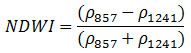
The value of this index ranges from -1 to 1. The common range for green vegetation is -0.1 to 0.4. See Narrowband Definitions for the allowable range of wavelengths.
Reference: Gao, B. "Normalized Difference Water Index for Remote Sensing of Vegetation Liquid Water from Space." Proceedings of SPIE 2480 (1995): 225-236.
Jackson, T., et al. "Vegetation Water Content Mapping Using Landsat Data Derived Normalized Difference Water Index for Corn and Soybeans." Remote Sensing of Environment 92 (2004): 475-482.
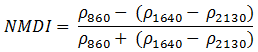
Normalized Multi-band Drought Index (NMDI)
This index takes into account a soil moisture background to monitor potential drought conditions. Three specific bands were chosen because of their unique response to variations in soil and vegetation moisture. The index uses the difference between two liquid-water absorption bands in the shortwave-infrared region (1640 and 2130 nm) as a measure of water sensitivity in vegetation and soil. This index is also commonly used in forest-fire detection.
As soil moisture increases, the index values decrease. Index values range from 0.7 to 1 for dry soil, 0.6 to 0.7 for soil with intermediate moisture, and less than 0.6 for wet soil.
References:
Wang, L., and J. Qu. "NMDI: A Normalized Multi-Band Drought Index for Monitoring Soil and Vegetation Moisture with Satellite Remote Sensing." Geophysical Research Letters 34 (2007): L20405.
Wang, L., and J. Qu. "Forest Fire Detection using the Normalized Multi-band Drought Index (NMDI) with Satellite Measurements." Agricultural and Forest Meteorology 148, No. 11 (2008): 1767-1776.
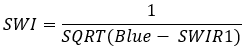
Simple Water Index (SWI)
This index as developed using statistical analysis to delineate water from shadows and built-up areas. The actual water pixel values are found below the pixel value of 5. Any pixel values greater than or equal to 5 represent water-like pixels such as built-up areas and shadows.
Reference: Malahlela, Oupa. (2016). "Inland waterbody mapping: towards improving discrimination and extraction of inland surface water features." International Journal of Remote Sensing. 37. 4574-4589. 10.1080/01431161.2016.1217441.
Water Band Index (WBI)
This index is a reflectance measurement that is sensitive to changes in canopy water status. As the water content of vegetation canopies increases, the strength of the absorption around 970 nm increases relative to that of 900 nm. Applications include canopy stress analysis, productivity prediction and modeling, fire hazard condition analysis, cropland management, and studies of ecosystem physiology.

There are two published Water Band Index equations that are reciprocals of each other. ENVI uses the equation documented in Penuelas, et al. (1995).
The common range for green vegetation is 0.8 to 1.2. See Narrowband Definitions for the allowable range of wavelengths.
References:
Penuelas, J., et al. "The Reflectance at the 950-970 Region as an Indicator of Plant Water Status." International Journal of Remote Sensing 14 (1993): 1887-1905.
Champagne, C., et al. "Mapping Crop Water Status: Issues of Scale in the Detection of Crop Water Stress Using Hyperspectral Indices." Proceedings of the 8th International Symposium on Physical Measurements and Signatures in Remote Sensing, Aussois, France (2001): 79-84.
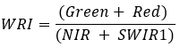
Water Ratio Index (WRI)
This index can be used to determine the amount of moisture in vegetation. The calculation technique of this index is based on the ratio between the full spectral index of two visible light ranges (green and red) and shortwave and mid-wave infrared ranges.
Reference:
Shen, Li and Changchun Li. “Water body extraction from Landsat ETM+ imagery using adaboost algorithm.” 2010 18th International Conference on Geoinformatics (2010): 1-4.
See Also
Spectral Indices, Vegetation Indices, Vegetation Analysis Tools, Agricultural Stress Tool, Fire Fuel Tool, Forest Health Tool, Vegetation and Its Reflectance Properties