ENVI provides the following indices for geologic features:
Clay Minerals Ratio
This band ratio highlights hydrothermally altered rocks containing clay and alunite.
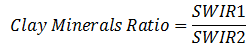
Where:
- Shortwave-infrared (SWIR) 1: 1.55-1.75 µm
- SWIR2: 2.08-2.35 µm
For Landsat TM and ETM+, this corresponds to bands 5 (SWIR1) and 7 (SWIR2). This index works with any multispectral sensor with bands that fall within the listed ranges.
Reference: Drury, S. Image Interpretation in Geology. London: Allen and Unwin (1987), 243 pp.
Ferrous Minerals Ratio
This band ratio highlights iron-bearing minerals.
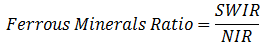
Where:
- SWIR: 1.55-1.75 µm
- NIR: 0.76-0.9 µm
For Landsat TM and ETM+, this corresponds to bands 5 (SWIR) and 4 (NIR). This index works with any multispectral sensor with bands that fall within the listed ranges.
References:
Segal, D. "Theoretical Basis for Differentiation of Ferric-Iron Bearing Minerals, Using Landsat MSS Data." Proceedings of Symposium for Remote Sensing of Environment, 2nd Thematic Conference on Remote Sensing for Exploratory Geology, Fort Worth, TX (1982): 949-951.
Drury, S. Image Interpretation in Geology. London: Allen and Unwin (1987), 243 pp.
Iron Oxide Ratio
This band ratio highlights hydrothermally altered rocks that have been subjected to oxidation of iron-bearing sulphides.
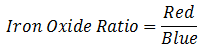
Where:
- Red: 0.63-0.69 µm
- Blue: 0.45-0.52 µm
For Landsat TM and ETM+, this corresponds to bands 3 (Red) and 1 (Blue). This index works with any multispectral sensor with bands that fall within the listed ranges.
References:
Segal, D. "Theoretical Basis for Differentiation of Ferric-Iron Bearing Minerals, Using Landsat MSS Data." Proceedings of Symposium for Remote Sensing of Environment, 2nd Thematic Conference on Remote Sensing for Exploratory Geology, Fort Worth, TX (1982): pp. 949-951.
Drury, S. Image Interpretation in Geology. London: Allen and Unwin (1987), 243 pp.
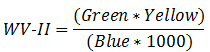
WorldView New Iron Index (WV-II)
This index uses WorldView-2 bands to identify pixels rich in iron oxide.
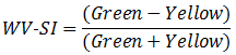
WorldView Soil Index (WV-SI)
This index uses WorldView-2 bands to identify pixels that primarily consist of soil.
Reference: Wolf, A. Using WorldView 2 Vis-NIR MSI Imagery to Support Land Mapping and Feature Extraction Using Normalized Difference Index Ratios. Unpublished report, Longmont, CO: DigitalGlobe (2010).
See Also
Spectral Indices