Tutorial: Burn Indices Tutorial
ENVI provides the following burn indices:
Burn Area Index (BAI)
This index highlights burned land in the red to near-infrared spectrum, by emphasizing the charcoal signal in post-fire images. The index is computed from the spectral distance from each pixel to a reference spectral point, where recently burned areas converge. Brighter pixels indicate burned areas.
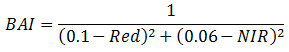
The data must be calibrated to reflectance before applying the index.
References:
Chuvieco, E., M. Pilar Martin, and A. Palacios. “Assessment of Different Spectral Indices in the Red-Near-Infrared Spectral Domain for Burned Land Discrimination.” Remote Sensing of Environment 112 (2002): 2381-2396.
Martín, M. Cartografía e inventario de incendios forestales en la Península Iberica a partir de imágenes NOAA AVHRR. Doctoral thesis, Universidad de Alcalá, Alcalá de Henares (1998).
Normalized Burn Ratio (NBR)
This index highlights burned areas in large fire zones greater than 500 acres. The formula is similar to NDVI, except that it uses near-infrared (NIR) and shortwave-infrared (SWIR) wavelengths.
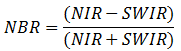
NBR was originally developed for use with Landsat TM and ETM+ bands 4 and 7, but it will work with any multispectral sensor with a NIR band between 0.76-0.9 µm and a SWIR band between 2.08-2.35 µm.
You can create pre-fire and post-fire NBR images, then subtract the post-fire image from the pre-fire image to create a differenced (or delta) NBR image that indicates burn severity.
Darker pixels indicate burned areas.
References:
Lopez Garcia, M., and V. Caselles. "Mapping Burns and Natural Reforestation using Thematic Mapper Data. Geocarto International 6 (1991): 31-37.
Key, C. and N. Benson, N. "Landscape Assessment: Remote Sensing of Severity, the Normalized Burn Ratio; and Ground Measure of Severity, the Composite Burn Index." In FIREMON: Fire Effects Monitoring and Inventory System, RMRS-GTR, Ogden, UT: USDA Forest Service, Rocky Mountain Research Station (2005).
Normalized Burn Ratio Thermal 1 (NBRT1)
This index uses a thermal band to enhance the NBR. It results in a better separability between burned and unburned land.
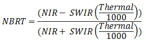
The Thermal band in this equation must be calibrated to brightness temperatures (in Kelvins). The NIR and SWIR bands should be calibrated to top-of-atmosphere reflectance. See the Burn Indices Tutorial for instructions.
NBRT1 was originally developed for use with Landsat TM and ETM+ bands 4, 7, and 6. However, it will work with any multispectral sensor with bands in the following ranges:
- NIR: 0.76 to 0.9 µm
- SWIR: 2.08 to 2.35 µm
- Thermal: 10.4 to 12.5 µm
Reference: Holden, Z., et al. "Evaluation of Novel Thermally Enhanced Spectral Indices for Mapping Fire Perimeters and Comparisons with Fire Atlas Data." International Journal of Remote Sensing 26 (2005): 4801-4808.
For Landsat 7 ETM+ and Landsat-8 imagery, you must follow some additional steps because the multispectral and thermal bands are in separate band groups. See the Burn Indices Tutorial for details.
See Also
Spectral Indices