Based on the format of the input file, point cloud and DSM layers can be colored or shaded by the following:
- Height
- Classification
- Intensity
- RGB
Use the Color by Height  , Color by Classification
  , Shade by Intensity
  , and Color by RGB
  toolbar buttons to toggle point coloring on and off. You can show or hide the layers of a Color by mode by enabling or disabling the check boxes in the ENVI LiDAR Layer Manager. If you hide the all Points layers in the ENVI LiDAR Layer Manager, the DSM displays only intensity or RGB.
ENVI LiDAR may apply point coloring or shading differently if QA Mode is enabled. The differences between the standard view (when QA Mode is not enabled) and the QA Mode view are described below.
Standard View Point Coloring
When you create a new project or open an existing one, ENVI LiDAR determines how the points and DSM are initially colored or shaded in the standard view as follows:
- If distinct values for RGB are present in the input file (that is, the RGB values are not all the same), then coloring is applied by RGB.
-
If distinct values for intensity are present in the input file (that is, the intensity values are not all the same), then coloring (or shading) is applied by intensity and height.
Note: Intensity is also affected by the Intensity Range Min/Max settings in the Production Parameters tab.
- If the input file does not have distinct values for intensity or RGB, then coloring is applied by height.
If distinct values for both RGB and intensity are present in the input file, use the Color by RGB and Shade by Intensity toolbar buttons to toggle between the two modes. The two modes cannot be applied at the same time, but you can toggle between them.
If more than one standard ASPRS classification value (defined in the LAS Specification Version 1.4 - R11) is present in the input file, click the Color by Classification toolbar button to color points by their classification values. Any points that have any of the user-definable classifications value will be colored in a single color. Any points that have any of the reserved classification values will also be colored in a single color. You can change the default classified data colors in the ENVI LiDAR preferences.
The classes appear in the ENVI LiDAR Layer Manager. You can toggle them on or off in the view.
You can toggle the Color by RGB or Shade by Intensity buttons on and off to further modulate the classification point coloring in the view.
Color by Classification and Color by Height are mutually exclusive and cannot be displayed at the same time. You can toggle between the two modes.
QA Mode Point Coloring
When you process the project and go to QA Mode, the points and DSM coloring is similar to standard view described above, with these exceptions:
- Color by Classification shows only the point classifications created during processing. It does not show the point classifications from the input file.
-
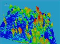
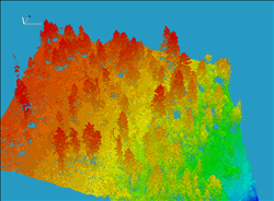
For Color by Height, the point classification colors created during processing are merged with the height color values from the input file. The result is that the height of the points is colored relative to the terrain (shown in image on the left), versus the standard view where the points are colored by the absolute height value stored for the point (shown in the image on the right):
You can manually control the applied color palette through the Height Palette Editor, and you can display a Height Legend to view the color key.