ENVI uses two modeling scenarios for the image-ground relationship when computing RPCs: a frame central projection and a line-central projection.
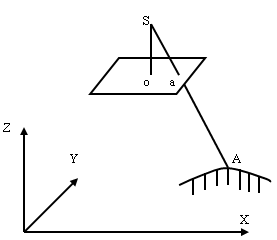
Frame camera and digital (frame central) aerial photography use the frame central projection. This projection has one perspective center (S) defined as the optical center of a camera lens through which all light rays pass and create imaging signatures in the image focal plane. Any object point (A), its image point (a), and its perspective center (S) are collinear in space. The principal point (o) is defined as the foot of the perpendicular from the perspective center to the plane of an aerial photograph.
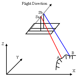
Imagery from pushbroom sensors and aerial photography from line central digital cameras use the line central projection. Each scan line has its own projection center, as the following figure shows.
To compute RPCs, the angles of each axis in the object space system, along with the location of the projection center, must also be determined. These are referred to as exterior orientation parameters. ENVI can automatically calculate these parameters based on GCPs that you select, but you can also edit them or manually enter them as needed.
References
Wang, Zhizhuo, 1990, Principles of Photogrammetry (with Remote Sensing), Beijing: Publishing House of Surveying and Mapping.
McGlone, J. C., editor, 2004, Manual of Photogrammetry, Fifth Edition, American Society for Photogrammetry and Remote Sensing.