The broadband greenness VIs are among the simplest measures of the general quantity and vigor of green vegetation. They are combinations of reflectance measurements that are sensitive to the combined effects of foliage chlorophyll concentration, canopy leaf area, foliage clumping, and canopy architecture. These VIs are designed to provide a measure of the overall amount and quality of photosynthetic material in vegetation, which is essential for understanding the state of vegetation for any purpose. These VIs are an integrative measurement of these factors and are well correlated with the fractional absorption of photosynthetically active radiation (fAPAR) in plant canopies and vegetated pixels. They do not provide quantitative information on any one biological or environmental factor contributing to the fAPAR, but broad correlations have been found between the broadband greenness VIs and canopy LAI.
Broadband greenness VIs compare reflectance measurements from the reflectance peak of vegetation in the near-infrared range to another measurement taken in the red range, where chlorophyll absorbs photons to store into energy through photosynthesis. Use of near-infrared measurements, with much greater penetration depth through the canopy than red, allows sounding of the total amount of green vegetation in the column until the signal saturates at very high levels. Because these features are spectrally quite broad, many of the broadband greenness indices can work effectively, even with image data collected from broadband multispectral sensors, such as AVHRR, Landsat TM, and QuickBird. Applications include vegetation phenology (growth) studies, land-use and climatological impact assessments, and vegetation productivity modeling.
Increases in leaf chlorophyll concentration or leaf area, decreases in foliage clumping, and changes in canopy architecture each can contribute to decreases in the NIR wavelengths and increases in the red wavelengths, thereby causing an increase in the broadband greenness values.
Difference Vegetation Index (DVI)
This index distinguishes between soil and vegetation, but it does not account for the difference between reflectance and radiance caused by atmospheric effects or shadows.
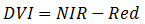
Reference: Tucker, C. "Red and Photographic Infrared Linear Combinations for Monitoring Vegetation. Remote Sensing of Environment 8 (1979): 127–150.
Enhanced Vegetation Index (EVI)
This index was originally developed for use with MODIS data as an improvement over NDVI by optimizing the vegetation signal in areas of high leaf area index (LAI). It is most useful in high LAI regions where NDVI may saturate. It uses the blue reflectance region to correct for soil background signals and to reduce atmospheric influences, including aerosol scattering.
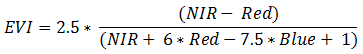
EVI values should range from 0 to 1 for vegetation pixels. Bright features such as clouds and white buildings, along with dark features such as water, can result in anomalous pixel values in an EVI image. Before creating an EVI image, you should mask out clouds and bright features from the reflectance image, and optionally threshold the pixel values from 0 to 1. See the Preprocessing section of the Spectral Indices topic.
Reference: Huete, A., et al. "Overview of the Radiometric and Biophysical Performance of the MODIS Vegetation Indices." Remote Sensing of Environment 83 (2002):195–213.
Forest Cover Index 1 (FCI1)
This index distinguishes forest canopies from other types of vegetation using multispectral reflectance imagery that includes a red edge band.
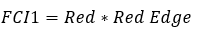
Forested areas will have lower FCI1 values due to the lower reflectance of trees and the presence of shadows within the canopy.
Reference: Becker, Sarah J., Craig S.T. Daughtry, and Andrew L. Russ. "Robust forest cover indices for multispectral images." Photogrammetric Engineering & Remote Sensing 84.8 (2018): 505-512.
Forest Cover Index 2 (FCI2)
This index distinguishes forest canopies from other types of vegetation using multispectral reflectance imagery that does not include a red edge band.
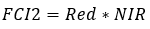
Forested areas will have lower FCI2 values due to the lower reflectance of trees and the presence of shadows within the canopy.
Reference: Becker, Sarah J., Craig S.T. Daughtry, and Andrew L. Russ. "Robust forest cover indices for multispectral images." Photogrammetric Engineering & Remote Sensing 84.8 (2018): 505-512.
Global Environmental Monitoring Index (GEMI)
This non-linear vegetation index is used for global environmental monitoring from satellite imagery and attempts to correct for atmospheric effects. It is similar to NDVI but is less sensitive to atmospheric effects. It is affected by bare soil; therefore, it is not recommended for use in areas of sparse or moderately dense vegetation.
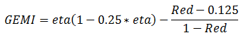
Where:
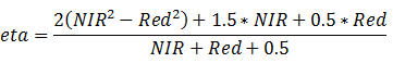
Reference: Pinty, B., and M. Verstraete. GEMI: a Non-Linear Index to Monitor Global Vegetation From Satellites. Vegetation 101 (1992): 15-20.
Green Atmospherically Resistant Index (GARI)
This index is more sensitive to a wide range of chlorophyll concentrations and less sensitive to atmospheric effects than NDVI.
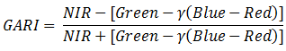
The gamma constant is a weighting function that depends on aerosol conditions in the atmosphere. ENVI uses a value of 1.7, which is the recommended value from Gitelson, Kaufman, and Merzylak (1996, page 296).
Reference: Gitelson, A., Y. Kaufman, and M. Merzylak. "Use of a Green Channel in Remote Sensing of Global Vegetation from EOS-MODIS." Remote Sensing of Environment 58 (1996): 289-298.
Green Chlorophyll Index (GCI)
This index is used to estimate leaf chlorophyll content across a wide range of plant species.
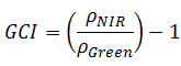
Having broad NIR and green wavelengths provides a better prediction of chlorophyll content while allowing for more sensitivity and a higher signal-to-noise ratio.
Reference: Gitelson, A., Y. Gritz, and M. Merzlyak. "Relationships Between Leaf Chlorophyll Content and Spectral Reflectance and Algorithms for Non-Destructive Chlorophyll Assessment in Higher Plant Leaves." Journal of Plant Physiology 160 (2003): 271-282.
Green Difference Vegetation Index (GDVI)
This index was originally designed with color-infrared photography to predict nitrogren requirements for corn.
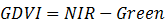
Reference: Sripada, R., et al. "Determining In-Season Nitrogen Requirements for Corn Using Aerial Color-Infrared Photography." Ph.D. dissertation, North Carolina State University, 2005.
Green Leaf Index (GLI)
This index was originally designed for use with a digital RGB camera to measure wheat cover, where the red, green, and blue digital numbers (DNs) range from 0 to 255.
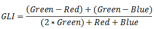
GLI values range from -1 to +1. Negative values represent soil and non-living features, while positive values represent green leaves and stems.
Reference: Louhaichi, M., M. Borman, and D. Johnson. "Spatially Located Platform and Aerial Photography for Documentation of Grazing Impacts on Wheat." Geocarto International 16, No. 1 (2001): 65-70.
Green Normalized Difference Vegetation Index (GNDVI)
This index is similar to NDVI except that it measures the green spectrum from 540 to 570 nm instead of the red spectrum. This index is more sensitive to chlorophyll concentration than NDVI.
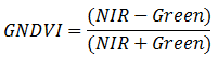
Reference: Gitelson, A., and M. Merzlyak. "Remote Sensing of Chlorophyll Concentration in Higher Plant Leaves." Advances in Space Research 22 (1998): 689-692.
Green Optimized Soil Adjusted Vegetation Index (GOSAVI)
This index was originally designed with color-infrared photography to predict nitrogren requirements for corn. It is similar to OSAVI, but it substitutes the green band for red.
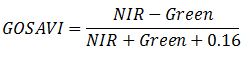
Reference: Sripada, R., et al. "Determining In-Season Nitrogen Requirements for Corn Using Aerial Color-Infrared Photography." Ph.D. dissertation, North Carolina State University, 2005.
Green Ratio Vegetation Index (GRVI)
This index is sensitive to photosynthetic rates in forest canopies, as green and red reflectances are strongly influenced by changes in leaf pigments.
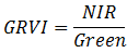
Reference: Sripada, R., et al. "Aerial Color Infrared Photography for Determining Early In-season Nitrogen Requirements in Corn." Agronomy Journal 98 (2006): 968-977.
Green Soil Adjusted Vegetation Index (GSAVI)
This index was originally designed with color-infrared photography to predict nitrogren requirements for corn. It is similar to SAVI, but it substitutes the green band for red.
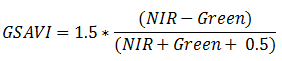
Reference: Sripada, R., et al. "Determining In-Season Nitrogen Requirements for Corn Using Aerial Color-Infrared Photography." Ph.D. dissertation, North Carolina State University, 2005.
Green Vegetation Index (GVI)
This index minimizes the effects of background soil while emphasizing green vegetation. It uses global coefficients that weigh the pixel values to generate new transformed bands. It is also known as the Landsat TM Tasseled Cap green vegetation index. Values range from -1 to 1.
GVI was originally designed for use with Landsat TM, but it will also work with the corresponding bands of Landsat ETM+ and Landsat 8.
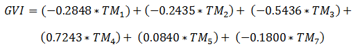
Reference: Kauth, R., and G. Thomas. "The Tasselled Cap-A Graphic Description of the Spectral-Temporal Development of Agricultural Crops as Seen By Landsat" In Proceedings of the LARS 1976 Symposium of Machine Processing of Remotely-Sensed Data, West Lafayette, IN: Purdue University, pp. 4B41-4B51.
Infrared Percentage Vegetation Index (IPVI)
This index is functionally the same as NDVI, but it is computationally faster. Values range from 0 to 1.
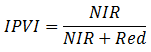
Reference: Crippen, R. "Calculating the Vegetation Index Faster." Remote Sensing of Environment 34 (1990): 71-73.
Leaf Area Index (LAI)
This index is used to estimate foliage cover and to forecast crop growth and yield. ENVI computes green LAI using the following empirical formula from Boegh et al (2002):
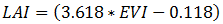
Where EVI is the Enhanced Vegetation Index value.
High LAI values typically range from approximately 0 to 3.5. However, when the scene contains clouds and other bright features that produce saturated pixels, the LAI values can exceed 3.5. You should ideally mask out clouds and bright features from your scene before creating an LAI image.
Reference: Boegh, E., H. Soegaard, N. Broge, C. Hasager, N. Jensen, K. Schelde, and A. Thomsen. "Airborne Multi-spectral Data for Quantifying Leaf Area Index, Nitrogen Concentration and Photosynthetic Efficiency in Agriculture." Remote Sensing of Environment 81, no. 2-3 (2002): 179-193.
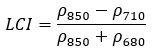
Leaf Chlorophyll Index (LCI)
This index is used to estimate chlorophyll content in higher plants, sensitive to variation in reflectance caused by chlorophyll absorption.
Reference: Datt, B. "Remote Sensing of Water Content in Eucalyptus Leaves." Journal of Plant Physiology 154, no. 1 (1999): 30-36.
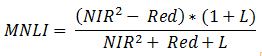
Modified Non-Linear Index (MNLI)
This index is an enhancement to the Non-Linear Index (NLI) that incorporates the Soil Adjusted Vegetation Index (SAVI) to account for the soil background. ENVI uses a canopy background adjustment factor (L) value of 0.5.
Reference: Yang, Z., P. Willis, and R. Mueller. "Impact of Band-Ratio Enhanced AWIFS Image to Crop Classification Accuracy." Proceedings of the Pecora 17 Remote Sensing Symposium (2008), Denver, CO.
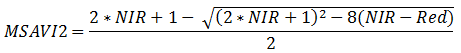
Modified Soil Adjusted Vegetation Index 2 (MSAVI2)
This index is a simpler version of the MSAVI index proposed by Qi, et al (1994), which improves upon the Soil Adjusted Vegetation Index (SAVI). It reduces soil noise and increases the dynamic range of the vegetation signal. MSAVI2 is based on an inductive method that does not use a constant L value (as with SAVI) to highlight healthy vegetation.
Reference: Qi, J., A. Chehbouni, A. Huete, Y. Kerr, and S. Sorooshian. "A Modified Soil Adjusted Vegetation Index." Remote Sensing of Environment 48 (1994): 119-126.
Modified Simple Ratio (MSR)
This index was developed an an improvement over RDVI by combining the Simple Ratio into the formula. The result is increased sensitivity to vegetation biophysical parameters.
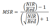
Reference: Chen, J. "Evaluation of Vegetation Indices and Modified Simple Ratio for Boreal Applications." Canadian Journal of Remote Sensing 22 (1996): 229-242.
Non-Linear Index (NLI)
This index assumes that the relationship between many vegetation indices and surface biophysical parameters is non-linear. It linearizes relationships with surface parameters that tend to be non-linear.
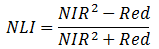
Reference: Goel, N., and W. Qin. "Influences of Canopy Architecture on Relationships Between Various Vegetation Indices and LAI and Fpar: A Computer Simulation." Remote Sensing Reviews 10 (1994): 309-347.
Normalized Difference Vegetation Index (NDVI)
This index is a measure of healthy, green vegetation. The combination of its normalized difference formulation and use of the highest absorption and reflectance regions of chlorophyll make it robust over a wide range of conditions. It can, however, saturate in dense vegetation conditions when LAI becomes high.
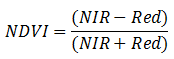
The value of this index ranges from -1 to 1. The common range for green vegetation is 0.2 to 0.8.
Reference: Rouse, J., R. Haas, J. Schell, and D. Deering. Monitoring Vegetation Systems in the Great Plains with ERTS. Third ERTS Symposium, NASA (1973): 309-317.
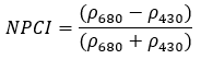
Normalized Pigment Chlorophyll Index (NPCI)
This index assess the cars to chlorophyll ratio at the leaf level.
Reference: Penuelas, J., et al. "Reflectance indices associated with physiological changes in nitrogen- and water-limited sunflower leaves." Remote Sensing of Environment 48, no. 2 (1994): 135-146.
Optimized Soil Adjusted Vegetation Index (OSAVI)
This index is based on the Soil Adjusted Vegetation Index (SAVI). It uses a standard value of 0.16 for the canopy background adjustment factor. Rondeaux (1996) determined that this value provides greater soil variation than SAVI for low vegetation cover, while demonstrating increased sensitivity to vegetation cover greater than 50%. This index is best used in areas with relatively sparse vegetation where soil is visible through the canopy.
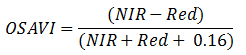
Reference: Rondeaux, G., M. Steven, and F. Baret. "Optimization of Soil-Adjusted Vegetation Indices." Remote Sensing of Environment 55 (1996): 95-107.
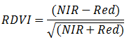
Renormalized Difference Vegetation Index (RDVI)
This index uses the difference between near-infrared and red wavelengths, along with the NDVI, to highlight healthy vegetation. It is insensitive to the effects of soil and sun viewing geometry.
Reference: Roujean, J., and F. Breon. "Estimating PAR Absorbed by Vegetation from Bidirectional Reflectance Measurements." Remote Sensing of Environment 51 (1995): 375-384.
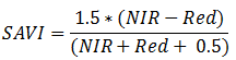
Soil Adjusted Vegetation Index (SAVI)
This index is similar to NDVI, but it suppresses the effects of soil pixels. It uses a canopy background adjustment factor, L, which is a function of vegetation density and often requires prior knowledge of vegetation amounts. Huete (1988) suggests an optimal value of L=0.5 to account for first-order soil background variations. This index is best used in areas with relatively sparse vegetation where soil is visible through the canopy.
Reference: Huete, A. "A Soil-Adjusted Vegetation Index (SAVI)." Remote Sensing of Environment 25 (1988): 295-309.
Simple Ratio (SR)
This index is a ratio of (1) the wavelength with highest reflectance for vegetation and (2) the wavelength of the deepest chlorophyll absorption. The simple equation is easy to understand and is effective over a wide range of conditions. As with the NDVI, it can saturate in dense vegetation when LAI becomes very high.

Reference: Birth, G., and G. McVey. "Measuring the Color of Growing Turf with a Reflectance Spectrophotometer." Agronomy Journal 60 (1968): 640-643.
Sum Green Index (SGI)
This index is one of the simplest vegetation indices used for detecting changes in vegetation greenness. Because light is strongly absorbed by green vegetation in this spectral region, the SG index is highly sensitive to small changes in vegetation canopy opening, such as what might occur with forest disturbance.
SGI is the mean of reflectance across the 500 nm to 600 nm portion of the spectrum. The sum is then normalized by the number of bands to convert it back to units of reflectance.
The value of this index ranges from 0 to more than 50 (in units of % reflectance). The common range for green vegetation is 10 to 25 percent reflectance.
Reference: Lobell, D., and G. Asner. "Hyperion Studies of Crop Stress in Mexico." Proceedings of the 12th Annual JPL Airborne Earth Science Workshop, Pasadena, CA (2003).
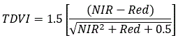
Transformed Difference Vegetation Index (TDVI)
This index is useful for monitoring vegetation cover in urban environments. It does not saturate like NDVI and SAVI.
Reference: Bannari, A., H. Asalhi, and P. Teillet. "Transformed Difference Vegetation Index (TDVI) for Vegetation Cover Mapping" In Proceedings of the Geoscience and Remote Sensing Symposium, IGARSS '02, IEEE International, Volume 5 (2002).
Triangular Greenness Index (TGI)
This index approximates the area of a triangle bounding a leaf reflectance spectrum, where the vertices are in the red, green, and blue wavelengths.
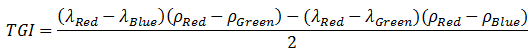
The Lambda (λ) terms represent the center wavelengths of the respective bands. The Rho (ρ) terms represent the pixel values of those bands. The original TGI equation (Hunt et al, 2011) used 670 nm, 550 nm, and 480 nm for the red, green, and blue wavelength centers, with a 10 nm band width. The following figure shows an ENVI spectral profile of a pixel that represents healthy, green vegetation. It shows the triangle bounding the vegetation spectrum.
The authors suggest that you can substitute broad bands and digital camera bands for the narrow bands. ENVI uses broadband definitions for the red, green, and blue wavelengths. In this case, TGI values can be lower than narrowband wavelength definitions. This is because averaging the signal over a larger wavelength region tends to reduce the green reflectance and increase the red reflectance.
The TGI is highly correlated with leaf chlorophyll content. TGI values are positive when the green reflectance is greater than a line between the red and blue vertices. This corresponds to green vegetation. TGI is negative when the green reflectance is less than the line between the red and blue vertices. This corresponds to features such as red soils.
Because this index measures red, green, and blue wavelengths, it is suitable for use with unmanned aerial vehicle (UAV) sensors with RGB cameras.
Reference: Hunt, E., C. Daughtry, J. Eitel, and D. Long. "Remote Sensing Leaf Chlorophyll Content Using a Visible Band Index." Agronomy Journal 103, No. 4 (2011): 1090-1099.
Visible Atmospherically Resistant Index (VARI)
This index is based on the ARVI and is used to estimate the fraction of vegetation in a scene with low sensitivity to atmospheric effects.
Reference: Gitelson, A., Kaufman, Y. J., Stark, R., and Rundquist, D., 2002, Novel algorithms for remote estimation of vegetation fraction. Remote Sensing of Environment, 80, 76–87.
Wide Dynamic Range Vegetation Index (WDRVI)
This index is similar to NDVI, but it uses a weighting coefficient (a) to reduce the disparity between the contributions of the near-infrared and red signals to the NDVI. The WDRVI is particularly effective in scenes that have moderate-to-high vegetation density when NDVI exceeds 0.6. NDVI tends to level off when vegetation fraction and leaf area index (LAI) increase, whereas the WDRVI is more sensitive to a wider range of vegetation fractions and to changes in LAI.
The weighting coefficient (a) can range from 0.1 to 0.2. ENVI uses a value of 0.2, as recommended by Henebry, Viña, and Gitelson (2004). To apply a different weighting coefficient value, use the Band Math tool.
References:
Gitelson, A. "Wide Dynamic Range Vegetation Index for Remote Quantification of Biophysical Characteristics of Vegetation." Journal of Plant Physiology 161, No. 2 (2004): 165-173.
Henebry, G., A. Viña, and A. Gitelson. "The Wide Dynamic Range Vegetation Index and its Potential Utility for Gap Analysis." Gap Analysis Bulletin 12: 50-56.
WorldView Improved Vegetative Index (WV-VI)
This index uses WorldView-2 bands to compute NDVI.
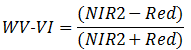
The value of this index ranges from -1 to 1. The common range for green vegetation is 0.2 to 0.8.
Reference: Wolf, A. Using WorldView 2 Vis-NIR MSI Imagery to Support Land Mapping and Feature Extraction Using Normalized Difference Index Ratios. Unpublished report, Longmont, CO: DigitalGlobe (2010).
See Also
Spectral Indices, Vegetation Indices, Vegetation Analysis Tools, Vegetation and Its Reflectance Properties, EO-1 Hyperion Vegetation Indices Tutorial